The first written records in the history of Dominica began in November 1493, when Christopher Columbus spotted the island. Prior to European contact, Dominica was inhabited by the Arawak. Dominica was a French colony from 1715 until the end of the Seven Years' War in 1763, and then became a British colony from 1763 to 1978. It became an independent nation in 1978.

Saint Lucia was inhabited by the Arawak and Kalinago Caribs before European contact in the early 16th century. It was colonized by the British and French in the 17th century and was the subject of several possession changes until 1814, when it was ceded to the British by France for the final time. In 1958, St. Lucia joined the short-lived semi-autonomous West Indies Federation. Saint Lucia was an associated state of the United Kingdom from 1967 to 1979 and then gained full independence on February 22, 1979.

The Kalinago, formerly known as Island Caribs or simply Caribs, are an Indigenous people of the Lesser Antilles in the Caribbean. They may have been related to the Mainland Caribs (Kalina) of South America, but they spoke an unrelated language known as Island Carib. They also spoke a pidgin language associated with the Mainland Caribs.
The Carib Expulsion from Martinique was the French-led ethnic cleansing that removed most of the Kalinago population in 1660 from the island of Martinique. This followed the French invasion in 1635 and its conquest of the Caribbean island that made it part of the French West Indies.

The Dominica Story: A History of the Island is a history book from 1975, written by Dominican historian Lennox Honychurch. It was the first published history of the island. Originally presented as a miniseries for Radio Dominica in 1974, the inaugural edition covered every aspect of local history from prehistory up to the then-present.
Lennox Honychurch is a Dominican historian and politician. He wrote 1975's The Dominica Story: A History of the Island, the 1980s textbook series The Caribbean People, and the 1991 travel book Dominica: Isle of Adventure. Also an artist and a curator, he was largely responsible for compiling the exhibit information for The Dominica Museum in Roseau. Honychurch is the grandson of writer and politician Elma Napier.

Cabrits National Park is on a peninsula at the north end of the Caribbean island of Dominica, north of Portsmouth. The park protects tropical forest, coral reefs and wetlands. There are hiking trails and an English garrison called Fort Shirley.

Scotts Head is a village on the southwest coast of Dominica, in Saint Mark Parish. In 2001, its population was 721. Predominantly a fishing village, Scotts Head overlooks Soufrière Bay, which is protected as the Soufrière Scotts Head Marine Reserve. It is also a popular snorkeling and diving site for tourists.

Massacre is a town in Saint Paul Parish, Dominica, with about 1,200 inhabitants. It is located on the central west coast of the island, to the north of the capital, Roseau, on the Massacre River.

Dominica Botanic Gardens is located on the Caribbean island-nation of Dominica, in the capital of Roseau. Once known as one of the finest botanical gardens in the region, it was severely damaged by Hurricane David in 1979. Following restoration efforts, it remains a focus of cultural life in Roseau, and a center of conservation research on Dominica.

The Kalinago Territory, previously known as the Carib Reserve or Carib Territory (outdated/derogatory), is a 3,700-acre (15 km2) district in the Caribbean island country of Dominica. It was established for the Indigenous Kalinago people who inhabited the region prior to European colonization and settlement.

The Invasion of Dominica was a successful French invasion of the island of Dominica in the British West Indies, during the American Revolutionary War. The action took place before British authorities in the Caribbean were aware that France had entered the war as an ally of the United States of America. The French governor in the West Indies, François Claude Amour, marquis de Bouillé, was notified on 17 August that France was at war, and organized the invasion, infiltrating spies to rally sympathetic French-speaking Dominican support.
The Capture of Saint Vincent was a French invasion that took place between 16 and 18 June 1779 during the American Revolutionary War. A French force commander named Charles-Marie de Trolong du Rumain landed on the island of Saint Vincent in the West Indies and quickly took over much of the British-controlled part of the island, assisted by local Black Caribs who held the northern part of the island.

The Capture of St Lucia was the result of a campaign from 18–28 December 1778 by British land and naval forces to take over the island, which was a French colony. Britain's actions followed the capture of the British-controlled island of Dominica by French forces in a surprise invasion in September 1778. During the Battle of St. Lucia, the British fleet defeated a French fleet sent to reinforce the island. A few days later French troops were soundly defeated by British troops during the Battle of Morne de la Vigie. Realising that another British fleet would soon arrive with reinforcements, the French garrison surrendered. The remaining French troops were evacuated, and the French fleet returned to Martinique, another French colony. St. Lucia stayed in the hands of the British.

The Chief of the Kalinago Territory presides over the Kalinago Council, the local government of the Kalinago Territory. The position is the equivalent of a village council chairperson elsewhere in Dominica. Beginning in the late 20th century, Kalinago Chiefs have also acted as a representative of the Kalinago Territory to other indigenous populations in the Caribbean region, and have worked with organizations including the Caribbean Organization of Indigenous Peoples and the United Nations Working Group on Indigenous Populations.
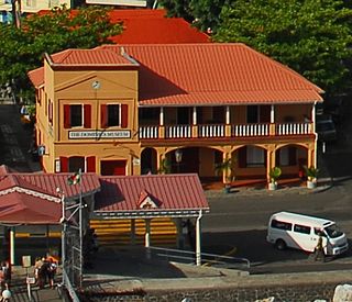
The Dominica Museum is the national museum of Dominica, an island nation in the Caribbean Lesser Antilles. It is located in the capital, Roseau, on a quay in front of the Old Market of Roseau, which was the centre for slave trading during colonial times. Its building was formerly an old market building and a post office dating to 1810.
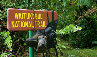
The Waitukubuli National Trail is a hiking trail spanning the island of Dominica. It is the longest hiking trail in the Caribbean, at 115 miles (185 km) long. Its name comes from the original Kalinago name of the island, Waitukubuli, meaning "tall is her body". The trails’s management falls under Dominica's Forestry Division.
Jean Le Comte was the first governor of Grenada, holding office from 1649 to 1654. He led systematic efforts to kill the indigenous Caribs or drive them off the island.
Fort Young was a major military installation on the Caribbean island of Dominica. It was built by the British in 1770. The fort was named for William Young, the island's first British governor. Today, only ruins remain of the fort, and the site is the location of the Fort Young Hotel.
Scotts Head Lighthouse is a small lighted navigational aid in Scott's Head, Dominica. It is a cylindrical metal post approximately 5 meters (16.4 ft) tall, with the lamp at the top of the post. It emits a quick-flashing white (Q.W.) light.


