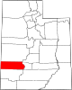
Brigham City is a city in Box Elder County, Utah, United States. The population was 19,650 at the 2020 census, up from the 2010 figure of 17,899. It is the county seat of Box Elder County. It lies on the western slope of the Wellsville Mountains, a branch of the Wasatch Range at the western terminus of Box Elder Canyon. Brigham City saw most of its growth during the 1950s and 1960s but has seen a struggling economy and stagnating growth. It is near the former headquarters of ATK Thiokol, now Northrop Grumman, the company that created the solid rocket boosters for the Space Shuttle.

Camp Floyd State Park Museum is a state park in the Cedar Valley in Fairfield, Utah, United States. The park includes a small part of the former Camp Floyd site, the Stagecoach Inn, and the Fairfield District School.
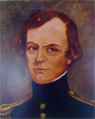
John Williams Gunnison was an American military officer and explorer.

Maeser Elementary was an elementary school in Provo, Utah. It was named after Karl G. Maeser. Built in 1898, it is the oldest school building in Provo, Utah. The school was designed by architect Richard C. Watkins, who also designed the Provo Third Ward Chapel and Amusement Hall, The Knight Block Building, and the Thomas N. Taylor Mansion.

Fort Laramie was a significant 19th-century trading post, diplomatic site, and military installation located at the confluence of the Laramie and the North Platte Rivers. They joined in the upper Platte River Valley in the eastern part of the present-day U.S. state of Wyoming. The fort was founded as a private trading-post in the 1830s to service the overland fur trade; in 1849, it was purchased by the United States Army. The site was located east of the long climb leading to the best and lowest crossing-point over the Rocky Mountains at South Pass and became a popular stopping-point for migrants on the Oregon Trail. Along with Bent's Fort on the Arkansas River, the trading post and its supporting industries and businesses were the most significant economic hub of commerce in the region.

The Beehive House was one of the official residences of Brigham Young, the second president of the Church of Jesus Christ of Latter-day Saints, in Salt Lake City, Utah, United States. The Beehive House gets its name from the beehive sculpture atop the house.

The Utah Territorial Statehouse, officially Territorial Statehouse State Park Museum, is a state park in Fillmore, Utah, preserving the original seat of government for the Utah Territory. Built from 1852 to 1855, the statehouse was initially intended as a larger structure, but only the south wing was completed before the project was abandoned due to lack of federal funding, and the Utah Territorial Legislature met in the building only once before the capital was moved to Salt Lake City in 1856.
Cove Fort is a fort, unincorporated community, and historical site located in Millard County, Utah. It was founded in 1867 by Ira Hinckley at the request of Brigham Young. One of its distinctive features is the use of volcanic rock in the construction of the walls, rather than the wood used in many mid-19th-century western forts. This difference in construction is the reason it is one of very few forts of this period still surviving.

Fort Douglas was established in October 1862, during the American Civil War, as a small military garrison about three miles east of Salt Lake City, Utah. Its purpose was to protect the overland mail route and telegraph lines along the Central Overland Route. It was officially closed in 1991 pursuant to BRAC action. A small portion of the fort remains in active military use as the Stephen A. Douglas Armed Forces Reserve Center, although it is expected the reserve center will be removed in the coming years, after the State of Utah provided, in 2023, funds for its relocation.

John Riggs Murdock was the leader of the most Mormon pioneer down-and-back companies in Latter-day Saint history, leading ox-drawn wagon trains that carried both merchandise and passengers "down and back" from Missouri to Utah.

Joseph Stacy Murdock was an American colonizer, leader, and Latter-day Saint hymn writer. He wrote the words to "Come Listen to a Prophet's Voice."

Washakie is a ghost town in far northern Box Elder County, Utah, United States. Lying some 3 miles (4.8 km) southeast of Portage, it was established in 1880 by the Church of Jesus Christ of Latter-day Saints for the settlement of the Northwestern Shoshone. The Washakie Indian Farm was home to the main body of this Native American band through most of the 20th century. By the mid-1970s, Washakie's residents were gone and the property sold to a private ranching operation. Today the tribal reservation consists of a small tract containing the Washakie cemetery, and the tribe is seeking to acquire more of the surrounding land. The old LDS chapel in Washakie is now on the National Register of Historic Places.

Lehi is a community within Mesa, Arizona. Lehi existed prior to the founding of Mesa, and was annexed by its much larger former neighbor in 1970. It is now the northern limit of central Mesa.

The Provo City Library is a public library serving residents of Provo and Orem in the U.S. state of Utah. It occupies the building of the former Brigham Young Academy, which was built in 1892. In 1976, the building was added to the National Register of Historic Places. After a remodeling process, it was rededicated as the Provo City Library on September 8, 2001.

The Harvey H. Cluff house is a house in central Provo, Utah, United States, built in 1877 that is on the National Register of Historic Places. It was originally owned by Harvey H. Cluff.
The Clark–Taylor House is a historic building located in Provo, Utah, United States. It is listed on the National Register of Historic Places. It has also been known as the T. N. Taylor Home. One of the oldest pioneer buildings in the state, the Clark–Taylor House was built around 1854. Thomas N. Taylor, a Provo Mayor, LDS bishop, and stake president, along with being a chairman of the board of trustees of BYU, lived in this home. The Clark–Taylor House was designated to the Provo City Historic Landmarks Registry on March 7, 1996.
Alexander Thomas "Scotty" Boyter was an American stonemason and builder who was active in Beaver, Utah. He is known for his use of local "pink tuff" rock, and several of his works are listed on the National Register of Historic Places. His brother James Boyter also was a mason and they sometimes worked together.
The Brigham City Co-op was one of the most successful cooperative enterprises of the Mormons in Utah.