
Nevis is a small island in the Caribbean Sea that forms part of the inner arc of the Leeward Islands chain of the West Indies. Nevis and the neighbouring island of Saint Kitts constitute one country: the Federation of Saint Kitts and Nevis. Nevis is located near the northern end of the Lesser Antilles archipelago, about 350 km east-southeast of Puerto Rico and 80 km west of Antigua. Its area is 93 square kilometres (36 sq mi) and the capital is Charlestown.

Saint Kitts and Nevis, officially known as the Federation of Saint Christopher and Nevis, is an island country in the West Indies. Located in the Leeward Islands chain of the Lesser Antilles, it is the smallest sovereign state in the Western Hemisphere, in both area and population. The country is a Commonwealth realm, with Elizabeth II as queen and head of state.
Saint Kitts and Nevis have one of the longest written histories in the Caribbean, both islands being among Spain's and England's first colonies in the archipelago. Despite being only two miles apart and quite diminutive in size, Saint Kitts and Nevis were widely recognized as being separate entities with distinct identities until they were forcibly united in the late 19th century.
Transport within the Caribbean islands of Saint Kitts and Nevis includes normal road traffic, public buses, taxis, ferries, airports, and one unusual railway.
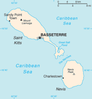
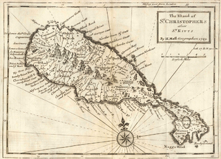
Saint Kitts, also known more formally as Saint Christopher Island, is an island in the West Indies. The west side of the island borders the Caribbean Sea, and the eastern coast faces the Atlantic Ocean. Saint Kitts and the neighbouring island of Nevis constitute one country: the Federation of Saint Kitts and Nevis. Saint Kitts and Nevis are separated by a shallow 3-kilometre (2 mi) channel known as "The Narrows".
The history of Anguilla runs from the beginning of human habitation, probably via settlement from South America, through its colonization by the English in the early modern period, to the present day. Following a series of rebellions and a short-lived period as an independent republic during the 1960s, Anguilla has been a separate British overseas territory since 1980.

Basseterre is the capital and largest city of Saint Kitts and Nevis with an estimated population of 14,000 in 2018. Geographically, the Basseterre port is located at 17°18′N62°44′W, on the south western coast of Saint Kitts Island, and it is one of the chief commercial depots of the Leeward Islands. The city lies within Saint George Basseterre Parish.
The economy of Saint Kitts and Nevis has traditionally depended on the growing and processing of sugar cane; decreasing world prices have hurt the industry in recent years. Tourism, export-oriented manufacturing, and offshore banking activity have assumed larger roles in Saint Kitts and Nevis. Most food is imported. The government has undertaken a program designed to revitalize the faltering sugar sector. It is also working to improve revenue collection in order to better fund social programs. In 1997, some leaders in Nevis were urging separation from Saint Kitts on the basis that Nevis was paying far more in taxes than it was receiving in government services, but the vote on cessation failed in August 1998. In late September 1998, Hurricane Georges caused approximately $445 million in damages and limited GDP growth for the year.
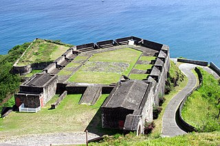
Brimstone Hill Fortress National Park is a UNESCO World Heritage Site, a well-preserved fortress on a hill on the island of St. Kitts in the Federation of St. Christopher and Nevis in the Eastern Caribbean. It was designed by British military engineers, and was built and maintained by African slaves. It is one of the best preserved historical fortifications in the Americas.

Saint Christopher-Nevis-Anguilla was a British colony in the West Indies from 1882 to 1983, consisting of the islands of Anguilla, Nevis, and Saint Christopher. From 1882 to 1951, and again from 1980, the colony was known simply as Saint Christopher and Nevis. Saint Christopher and Nevis gained independence in 1983 as the Federation of Saint Kitts and Nevis, while Anguilla would remain a British overseas territory.

Saint Anne Sandy Point is one of 14 administrative parishes that make up Saint Kitts and Nevis. It is the smallest parish on St. Kitts in terms of area, at just 5 square miles (13 km2). It is located on the main island of Saint Kitts and the parish capital is Sandy Point Town.
Saint George Basseterre is one of 14 administrative parishes that make up Saint Kitts and Nevis. It is the largest parish on Saint Kitts and the second largest parish in Saint Kitts and Nevis. It is by far the most populous parish in the federation, holding nearly a third of the country's population. It is home to the city of Basseterre, capital of Saint Kitts and Nevis, and also has a longer coastline than any other parish in Saint Kitts and Nevis.

Saint Thomas Middle Island is one of 14 administrative parishes that make up Saint Kitts and Nevis. It is the third largest parish on the island of Saint Kitts, and fourth largest in the federation. The parish capital is Middle Island.

Saint Thomas Lowland is one of 5 Nevis parishes which are in turn part of the 14 administrative parishes that make up the Federation of Saint Kitts and Nevis. Leeward Islands, Lesser Antilles, West Indies.

Fort Charles is an abandoned British fort on the island of Nevis. It is now mostly in ruins.
Sandy Point is the second largest town in the island of Saint Kitts, Saint Kitts and Nevis. This town is situated on the north-west coast of St.Kitts and is the capital of Saint Anne Sandy Point Parish.
Sir Thomas Warner was a captain in the guards of James I of England who became an explorer in the Caribbean. In 1620 he served at the brief-lived English settlement of Oyapoc in present-day Guyana of South America, which was abandoned the same year. The Dutch controlled most of the territory. Warner is noted for settling on Saint Kitts and establishing it in 1624 as the first English colony in the Caribbean.
The following outline is provided as an overview of and topical guide to Saint Kitts and Nevis:
Afro-Kittitians and Afro-Nevisians are Saint Kitts and Nevis people whose ancestry lies within the continent of Africa, most notably West Africa.
The Indian community in Saint Kitts and Nevis is made up of Indo-Kittitians, Indo-Nevisians, non-resident Indians and persons of Indian origin. Indo-Kittitians and Indo-Nevisians are nationals of Saint Kitts and Nevis whose ancestry lies within the country of India. The community originated from the Indian indentured workers brought to Saint Kitts and Nevis by the British in 1861 and 1874 respectively. By 1884, most of the community had emigrated to Caribbean nations with larger Indian populations such as Trinidad and Tobago, Guyana and Suriname.

