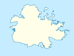
Antigua and Barbuda is a sovereign island country in the Caribbean. It lies at the conjuncture of the Caribbean Sea and the Atlantic Ocean in the Leeward Islands part of the Lesser Antilles.
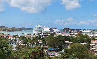
St. John's is the capital and largest city of Antigua and Barbuda, part of the West Indies in the Caribbean Sea. With a population of 22,219, St. John's is the commercial centre of the nation and the chief port of the island of Antigua.

Fort Henry National Historic Site is located in Kingston, Ontario, Canada on Point Henry, a strategic, elevated point near the mouth of the Cataraqui River where it flows into the St. Lawrence River at the east end of Lake Ontario. The fort and the point on which the fort was built were named after Henry Hamilton, former Lieutenant-Governor of the Province of Quebec.

Portland Harbour is located beside the Isle of Portland, Dorset, on the south coast of England. Construction of the harbour began in 1849; when completed in 1872, its 520-hectare (1,300-acre) surface area made it the largest human-made harbour in the world, and it remains one of the largest in the world today. It is naturally sheltered by Portland to the south, Chesil Beach to the west and mainland Dorset to the north. It consists of four breakwaters: two southern and two northern. These have a total length of 4.57 km (2.84 mi) and enclose approximately 1,000 ha of water.

Cockatoo Island Wareamah is a UNESCO World Heritage Site at the confluence of the Parramatta River and Lane Cove River in Sydney Harbour, New South Wales, Australia.

Fort Cumberland is a pentagonal artillery fortification erected to guard the entrance to Langstone Harbour, east of the Dockyard of Portsmouth on the south coast of England. It was sited to protect the Royal Navy Dockyard, by preventing enemy forces from landing in Langstone Harbour and attacking from the landward side. Fort Cumberland is widely recognised as the finest example of a bastion trace fort in England. It is a scheduled monument and a Grade II* listed building

Saint Paul, officially the Parish of Saint Paul, is a parish of Antigua and Barbuda on the island of Antigua. Saint Paul borders Saint Peter and Saint John to the north, Saint Mary to the west, and Saint Philip to the east. Saint Paul is dominated by farmland in the north, with various creeks and Potworks Dam marking its northern border, and low-lying hills to the south, defining its western border with Saint Mary. The largest city fully within the parish is Liberta, the fourth largest city in the country. The parish capital, and the location of the parish church, is Falmouth. The main economic and tourism hub of the parish is English Harbour. Saint Paul was created with the other five original parishes on 11 January 1692. It had a population of 9,004 in 2018.

Antigua, also known as Waladli or Wadadli by the native population, is an island in the Lesser Antilles. It is one of the Leeward Islands in the Caribbean region and the most populous island of the country of Antigua and Barbuda. Antigua and Barbuda became an independent state within the Commonwealth of Nations on 1 November 1981.

Fort St. Angelo is a bastioned fort in Birgu, Malta, located at the centre of the Grand Harbour. It was originally built in the medieval period as a castle called the Castrum Maris. It was rebuilt by the Order of Saint John as a bastioned fort called Fort Saint Angelo between the 1530s and the 1560s, and it is best known for its role as the Order's headquarters during the Great Siege of Malta of 1565. A major reconstruction to designs of Carlos de Grunenbergh took place in the 1690s, giving the fort its current appearance.

English Harbour is a natural harbour and settlement on the island of Antigua in the Caribbean, in the extreme south of the island. The settlement takes its name from the nearby harbour in which the Royal Navy established its base of operations for the area during the eighteenth century. Its population is 759.

Nelson's Dockyard is a cultural heritage site and marina in English Harbour, located in Saint Paul Parish on the Caribbean island of Antigua, in Antigua and Barbuda. It was built in the early 18th century and abandoned by the British Navy in 1889.

The Dawes Point Battery remains is a heritage-listed former artillery fortification and now visitor attraction located adjacent to the southern pylon of the Sydney Harbour Bridge at Hickson Road in inner city Sydney, on the boundary between Dawes Point and The Rocks in the City of Sydney local government area of New South Wales, Australia. It was built and modified from 1791 to 1925 by Lieutenant William Dawes, Robert Ross, Francis Greenway, and George Barney. The property is owned by Property NSW, an agency of the Government of New South Wales. It was added to the New South Wales State Heritage Register on 10 May 2002.

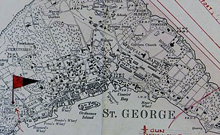
The Historic Town of St George and Related Fortifications is the name used by the United Nations Educational, Scientific and Cultural Organization's (UNESCO) World Heritage Committee to identify collectively as a World Heritage Site St. George's Town, founded in 1612, and a range of fortifications, batteries, and magazines built between 1612 and 1939, the last of which was removed from use in 1953.

Fort Davis, is a coastal defence fortification close to Whitegate, County Cork, Ireland. Together with similar structures at Fort Mitchel, Fort Camden (Crosshaven), and Templebreedy Battery, the fort was built to defend the mouth of Cork Harbour. Though used as a fortification from the early 17th century, the current structures of the 74-acre site date primarily from the 1860s. Originally named Fort Carlisle and operated by the British Armed Forces, the fort was handed-over to the Irish Defence Forces in 1938, and renamed Fort Davis. The facility is owned by the Department of Defence, and is used as a military training site with no public access.
Fort George is a square fort built on the crest of Mount Hill to the west of St. George's Town, near to, but outside of the boundaries of the original main British Army camp in the Imperial fortress colony of Bermuda, St. George's Garrison.

Shirley Heights is an historic military compound in Antigua. It was built in the 1780s to protect the Naval Dockyard in English Harbour. It is part of Nelson's Dockyard National Park and part of a UNESCO World Heritage Site.

Fort Berkeley is a historic military fort on the island of Antigua. It is located at the entrance to English Harbour in Saint Paul parish. The fort was built in 1704 and expanded in the mid 18th century. It is part of Nelson's Dockyard National Park and the Antigua Naval Dockyard and Related Archaeological Sites UNESCO World Heritage Site.
The Antigua Naval Dockyard and Related Archaeological Sites is a 255 ha UNESCO World Heritage Site in Saint Paul Parish, Antigua, Antigua and Barbuda. It constitutes a collection of Georgian era naval structures, namely a naval dockyard and related supporting compounds. This maritime complex was established during a period marked by intense competition among European nations vying for dominance at sea to secure authority over the profitable sugar-producing islands in the Eastern Caribbean.