Gallery
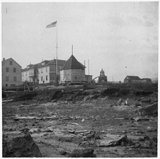
 Barracks at Fort Davis, 1900
 Blueprint of Nome and Fort Davis 1908
 Map of fort itself 1909
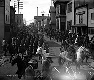 Parade in Nome 1908 showing soldiers
Fort Davis was a United States Army post established in the Nome Census Area of Alaska in 1900. It was named for General Jefferson C. Davis, the military commander of Alaska from 1868 to 1870.
The Nome Gold Rush led to unrest from claim jumping, claim filing errors, and a general lack of authority. The Army was sent to the Nome area to maintain order. [1] Before Fort Davis was established, soldiers from the port of St. Michael were sent to maintain order in Nome. [2] St. Michael was a transit harbor for the Klondike gold rush and due to its growth during the rush, a military fort was built there in 1897. [3]
Fort Davis was abandoned around 1917 [4] or possibly later based on other sources. [5]
| Historical population | |||
|---|---|---|---|
| Census | Pop. | %± | |
| 1910 | 180 | — | |
Fort Davis appeared once on the 1910 U.S. Census as an unincorporated military installation. Owing to its deactivation around 1917, it was not reported again.


Golovin is a city in Nome Census Area, Alaska, United States. At the 2010 census the population was 156, up from 144 in 2000.

Nome is a city in the Nome Census Area in the Unorganized Borough of Alaska, United States. The city is located on the southern Seward Peninsula coast on Norton Sound of the Bering Sea. It had a population of 3,699 recorded in the 2020 census, up from 3,598 in 2010. Nome was incorporated on April 9, 1901, and was once the most-populous city in Alaska. Nome lies within the region of the Bering Straits Native Corporation, which is headquartered in Nome.
St. Michael, historically referred to as Saint Michael, is a city in Nome Census Area, Alaska. The population was 401 at the 2010 census, up from 368 in 2000.

Eagle is a city on the south bank of the Yukon River near the Canada–US border in the Southeast Fairbanks Census Area, Alaska, United States. It includes the Eagle Historic District, a U.S. National Historic Landmark. The population was 86 at the 2010 census. Every February, Eagle hosts a checkpoint for the long-distance Yukon Quest sled dog race.

Circle is a census-designated place (CDP) in Yukon-Koyukuk Census Area, Alaska, United States. At the 2010 census the population was 104, up from 100 in 2000.

The District of Alaska was the federal government’s designation for Alaska from May 17, 1884 to August 24, 1912, when it became Alaska Territory. Previously (1867–1884) it had been known as the Department of Alaska, a military designation.
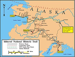
The Iditarod Trail, also known historically as the Seward-to-Nome Trail, is a thousand-plus mile (1,600 km) historic and contemporary trail system in the US state of Alaska. The trail began as a composite of trails established by Alaskan native peoples. Its route crossed several mountain ranges and valleys and passed through numerous historical settlements en route from Seward to Nome. The discovery of gold around Nome brought thousands of people over this route beginning in 1908. Roadhouses for people and dog barns sprang up every 20 or so miles. By 1918 World War I and the lack of 'gold fever' resulted in far less travel. The trail might have been forgotten except for the 1925 diphtheria outbreak in Nome. In one of the final great feats of dog sleds, twenty drivers and teams carried the life-saving serum 674 miles (1,085 km) in 127 hours. Today, the Iditarod Trail Sled Dog Race serves to commemorate the part the trail and its dog sleds played in the development of Alaska, and the route and a series of connecting trails have been designated Iditarod National Historic Trail.
Tasker Howard Bliss was a United States Army officer who served as Chief of Staff of the United States Army from September 22, 1917 until May 18, 1918. He was also a diplomat involved in the peace negotiations of World War I, and was one of the co-signatories of the Treaty of Versailles for the United States.
The Nome mining district, also known as the Cape Nome mining district, is a gold mining district in the U.S. state of Alaska. It was discovered in 1898 when Erik Lindblom, Jafet Lindeberg and John Brynteson, the "Three Lucky Swedes", found placer gold deposits on Anvil Creek and on the Snake River few miles from the future site of Nome. Word of the strike caused a major gold rush to Nome in the spring of 1899.
Fort Egbert was a U.S. Army base in Eagle, Alaska. It operated from 1899 to 1911.
The Alaska Communications System (ACS), also known as the Washington-Alaska Military Cable and Telegraph System (WAMCATS), was a system of cables and telegraph lines authorized by the U.S. Congress in 1900 and constructed by the U.S. Army Signal Corps. The communications lines were to serve both military and civilian needs in the territory of Alaska. By 1904, ACS comprised some 2,100 miles (3,400 km) of undersea cable, over 1,400 miles (2,300 km) of land lines, and a wireless segment across at least 107 miles (172 km). On May 15, 1936 WAMCATS was renamed the U.S. Army Alaska Communications System. The Alaska Communications System remained under the control of the Army Signal Corps until 1962 when it was taken over by the U.S. Air Force. The ACS handled the radioteletype, radio telephone, 500 kHz ship-to-shore frequencies, collected communications intelligence, and other services for more than half a century in Alaska.

The history of Fairbanks, the second-largest city in Alaska, can be traced to the founding of a trading post by E.T. Barnette on the south bank of the Chena River on August 26, 1901. The area had seen human occupation since at least the last ice age, but a permanent settlement was not established at the site of Fairbanks until the start of the 20th century.

Cape Nome is a headland on the Seward Peninsula in the U.S. state of Alaska. It is situated on the northern shore of Norton Sound, 15 miles (24 km) to the east of Nome also on Norton Sound. It is delimited by the Norton Sound to the south, Hastings Creek on the west, a lagoon on the east and an estuary formed by the Flambeau River and the Eldorado River. From the sea shore, Cape Nome extends inland by about 4 miles (6.4 km), connected by road with Nome.

The Nome Gold Rush was a gold rush in Nome, Alaska, approximately 1899–1909. It is separated from other gold rushes by the ease with which gold could be obtained. Much of the gold was lying in the beach sand of the landing place and could be recovered without any need for a claim. Nome was a sea port without a harbor, and the biggest town in Alaska.
Fort Gibbon was a U.S. Army base near Tanana, Alaska. It was active from 1899 to 1923.

Mount Billy Mitchell is a prominent 6,919-foot (2,109 m) peak located in the Chugach Mountains, 35 miles (56 km) east of Valdez and 12 miles (19 km) west of the Copper River in the U.S. state of Alaska. This mountain forms a prominent and easily visible landmark between mile markers 43 and 51 of the Richardson Highway, as the highway passes just to its west between Tonsina and the Thompson Pass.
The Nome–Council Highway is a highway that runs for 71.970 miles (115.824 km) between the communities of Council and Nome in the Nome Census Area of the Unorganized Borough in the U.S. state of Alaska. The road travels east from Nome, following the shore of the Bering Sea until it reaches the ghost town of Solomon. From there, the route travels northeast through the interior of the Seward Peninsula before it terminates on the south bank of the Niukluk River, south of Council. One of three highways traveling from Nome to surrounding communities, the highway is disconnected from the rest of the Alaska Highway System. The route is unpaved for its entire length and becomes impassable for automobiles in the winter outside of a short portion immediately outside of Nome. The portion of the road between Nome and Solomon is part of the Iditarod Trail and the highway passes several historic sites associated with the trail and the area's gold mining history.
Fort St. Michael was an installation of the United States Army at St. Michael, Alaska, on St. Michael Island in Norton Bay on the central west coast of Alaska. The fort was in active service between 1897 and 1925, and was originally established to maintain order during the Klondike Gold Rush for which St. Michael was a major transshipment point for people and goods moving up the Yukon River, whose mouth is nearby but is inaccessible to ocean-going ships. The installation later became the endpoint of the WAMCATS cable, a military communications cable extending across Alaska. Its importance declined substantially after the Alaska Railroad was completed in 1923, providing year-round service to the interior which was superior to the seasonal transport service of the river. The post was closed in 1925, and the military burials of its graveyard relocated to Sitka National Cemetery in 1929. When surveyed in 1976, only three buildings remained of the once extensive installation.
The history of the Jews in Alaska began before the Alaska Purchase in 1867. Jews from Imperial Russia lived there periodically as fur traders, and a Jewish community has existed since the 1880s. The Klondike and Nome gold rushes attracted Jews to Alaska to seek their fortunes as miners and businessmen and resulted in the first organized Jewish communities. In the Nazi period, Jewish refugee resettlement in Alaska was seriously considered by the government, but after facing backlash, never came to be. Alaskan Jews played a significant role in business and politics before and after statehood, and have included mayors, judges, senators and governors. Today, there are Jews living in every urban area of the state.

Senator was a steel-hulled steamship launched in 1898. She served as a troopship during the Spanish-American War and was an important part of the Nome gold rush. She spent thirty years in the coastwise shipping trade between Alaska and San Diego, until she was scrapped in Osaka, Japan in 1935.
{{cite web}}: Missing or empty |title= (help)| General | |
|---|---|
| National libraries | |
Coordinates: 64°29′00″N165°19′00″W / 64.48333°N 165.31667°W
| | This article about a location in the Nome Census Area, Alaska is a stub. You can help Wikipedia by expanding it. |