Jefferson Columbus Davis was a regular officer of the United States Army during the American Civil War, known for the similarity of his name to that of Confederate President Jefferson Davis and for his killing of a superior officer in 1862.

The geology of the Ohio River, with but a single series of rapids halfway in its length from the confluence of the Monongahela and Allegheny rivers to its union with the Mississippi, made it inevitable that a town would grow on the site. Louisville, Kentucky was chartered in the late 18th century. From its early days on the frontier, it quickly grew to be a major trading and distribution center in the mid 19th century, important industrial city in the early 20th, declined in the mid 20th century, before revitalizing in the late 20th century as a culturally-focused mid-sized American city.

TheGalt House Hotel is a 25-story, 1,300-room hotel in Louisville, Kentucky, established in 1972. It is named for a nearby historic hotel erected in 1835 and demolished in 1921. The Galt House is the city's only hotel on the Ohio River.
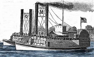
USS Monarch was a United States Army sidewheel ram that saw service in the American Civil War as part of the United States Ram Fleet and the Mississippi Marine Brigade. She operated on the Mississippi River and Yazoo River during 1862 and 1863.

The Salt River is a 150-mile-long (240 km) river in the U.S. state of Kentucky that drains 2,920 square miles (7,600 km2). It begins near Parksville, Kentucky, rising from the north slope of Persimmon Knob south of KY 300 between Alum Springs and Wilsonville, and ends at the Ohio River near West Point. Taylorsville Lake is formed from the Salt River, and Guist Creek Lake is also in its drainage basin.

Fort Hill is a promontory overlooking downtown Frankfort, Kentucky. It is the site of two earthwork forts from the American Civil War. Fort Hill is on the National Register of Historic Places and is now a public park. [[File:Fort Hill-CW Heritage Tour 05 002.jpg|alt=People walking down a concrete path between two sloping hills with extensive plant growth surrounding them.

Louisville in the American Civil War was a major stronghold of Union forces, which kept Kentucky firmly in the Union. It was the center of planning, supplies, recruiting and transportation for numerous campaigns, especially in the Western Theater. By the end of the war, Louisville had not been attacked once, although skirmishes and battles, including the battles of Perryville and Corydon, took place nearby.

Old Fort Harrod State Park is a park located in Harrodsburg, Kentucky in the United States. The park encompasses 15 acres (6.1 ha) and features a reconstruction of Fort Harrod, the first permanent American settlement in the state of Kentucky. The park was founded in November 1934 as Pioneer Memorial State Park, and dedicated by President Franklin D. Roosevelt and Governor Ruby Laffoon.
The 32nd Indiana Monument, also known as the August Bloedner Monument, honors the Union soldiers of the 32nd Indiana Volunteer Infantry Regiment, also known as Indiana's "1st German" regiment, who died in the Battle of Rowlett's Station on December 17, 1861, near Munfordville, Kentucky. Originally placed at Fort Willich, near Munfordville, in January 1862, the monument was moved to Cave Hill National Cemetery at Louisville, Kentucky, in June 1867. Due to its fragile condition, the monument was removed from the national cemetery in 2008. After undergoing conservation treatment at the University of Louisville, it was placed on display at the Frazier History Museum lobby in August 2010. Although it is no longer in its original location, the 32nd Indiana Monument is generally considered to be the oldest surviving memorial to the American Civil War. A replacement monument at Cave Hill National Cemetery was dedicated in December 2011.

Hadley Mountain is a mountain located in the southern Adirondacks in the U.S. state of New York and is the second-highest peak in Saratoga County after neighboring Tenant Mountain. The Hadley Mountain Fire Observation Station was listed on the National Register of Historic Places on September 23, 2001 for its role as a Fire lookout tower with the New York State Forest Preserve. Hadley Mountain is the highest of the three peaks that form the West Mountain ridge.

Louisville's fortifications for the American Civil War were designed to protect Louisville, Kentucky, as it was an important supply station for the Union's fight in the western theater of the war. They were typically named for fallen Union officers; usually those that served in the Army of the Ohio. The inspiration for building the forts came in October 1862, when Confederate forces engaged in their largest attack in Kentucky, only to be halted at the Battle of Perryville. Construction began in 1863, going at a slow pace until Confederate forces marched on Nashville, Tennessee, in the autumn of 1864. This caused General Hugh Ewing to demand from the city to force both military convicts and local "loafers" to help build the fortifications. Due to military engineers being needed on the front lines, the fortifications in Louisville were designed by civilian assistant engineers, as were the ones in Cincinnati, Ohio. Louisville was never endangered, so the guns never fired, save for salutes.
The 7th Kentucky Infantry Regiment was an infantry regiment that served in the Union Army during the American Civil War.
Patterson's Independent Company Kentucky Volunteer Engineers was an engineer company that served in the Union Army during the American Civil War.
The 4th Kentucky Cavalry Regiment was a cavalry regiment that served in the Union Army during the American Civil War.

Located in the southeastern section of Manchester, Connecticut, the Case Mountain Recreational Area encompasses 640 acres (2.6 km2) of combined open space and watershed land stretching from the Glastonbury border north to Case Pond. Some trails lead south across the Glastonbury border to a larger area of land owned by the Town of Manchester to maintain the Buckingham Reservoir and provide drinking water to Manchester. The land around the reservoir is open to recreation. While there is a hill named Case Mountain in this area, locals refer to this entire trail system and forest in Manchester and Glastonbury simply as “Case Mountain.”
17th Ohio Battery was an artillery battery that served in the Union Army during the American Civil War.
The 49th Regiment Indiana Infantry was an infantry regiment that served in the Union Army during the American Civil War.
The 108th Illinois Volunteer Infantry was an infantry regiment in the Union Army during the American Civil War.
The Civil War Trust's Civil War Discovery Trail is a heritage tourism program that links more than 600 U.S. Civil War sites in more than 30 states. The program is one of the White House Millennium Council's sixteen flagship National Millennium Trails. Sites on the trail include battlefields, museums, historic sites, forts and cemeteries.