Fort Fareham

Last updated

Fort Fareham
Fort Fareham west caponier.jpg
The north face of the derelict west caponier at Fort Fareham
Type Palmerston Fort
Location Fareham
AreaHampshire
Built18611868
Owner Fareham Urban District Council
Hampshire UK location map.svg
Red pog.svg
Location of Fort Fareham in Hampshire
Fort Fareham north casemates with steps to ramparts and officers' mess beyond Fort Fareham north casemates.jpg
Fort Fareham north casemates with steps to ramparts and officers' mess beyond

Fort Fareham is one of the Palmerston Forts, in Fareham, England. After the Gosport Advanced Line of Fort Brockhurst, Fort Elson, Fort Rowner, Fort Grange and Fort Gomer had been approved by the Royal Commission on the Defence of the United Kingdom a decision was made to build an outer line of three more forts two miles in advance of the Gosport Advanced Line. [1] Of these three projected forts only Fort Fareham was built due to the need to cut costs. It acted as a hinge between the forts on Portsdown Hill and those of the Gosport Advanced Line, filling the gap at Fareham. It has been a Grade II Listed Building since 1976. [2]

Contents

Design

Fort Fareham top plan FortFarehamPlan.jpg
Fort Fareham top plan

Fort Fareham is located on land immediately to the west of Salterns Creek, adjacent to the railway line (which it also protected) from Fareham to Gosport which passed its northeast corner. It is 3,500 yards in advance of Fort Elson, the most northerly fort of the Gosport Advanced Lines. Fort Fareham acted as the link between the Portsdown Hill line of forts and was visible from Fort Wallington which is 2,500 yards to the North and East. The strategically important town of Fareham along with Fareham creek lie in between the two. Fort Fareham was also to provide protection for the road linking Gosport to the Portsdown Forts. Due to the need to protect the ground in front of the Gosport Advanced Line and because of its isolated position Fort Fareham was constructed as a polygonal work with a strong ability to defend itself from being overrun. Its position made an attack on the Gosport Lines very hazardous without it first being captured or disabled.

In trace Fort Fareham is a pentagon with a west facing rampart for the main armament and a north flanking rampart with armament to command the Fareham gap towards Fort Wallington. The ramparts to the south were subject to enfilade fire and were therefore given a greater measure of protection by hiding the guns in a complex range of Haxo casemates. This fort is the only one of the Palmerston Forts to receive such a concentration of Haxo casemates. The fort is surrounded by a ditch that was intended to be wet but problems with obtaining and holding water in this meant that for much of its life the northern portion remained dry. The ditch is ably protected by a grand caponier to the west with smaller demi-caponiers at the north, southwest and south salient angles. [3] A decision was made in the later stages of construction that resulted in the choice of a redan at the rear, closing the gorge of the fort, rather than a self-contained keep, like those of the inner three forts of the Gosport Advanced Line. [4]

History

Construction (1861-1868)

The construction lasted from 1861 to 1868, with a total cost of £104,557. The report of the 1869 Defence Committee concluded that Fort Fareham was '...skilfully constructed as regards stability and permanency and when completed according to the approved plans will be suited to the requirements of modern armaments, and when its ditch was filled with water would afford a fair amount of resistance to any attack to which it may be exposed.' [5]

Active fort (1868-1902)

The original design of the fort called for forty-nine 7-inch R.B.L. guns with five 64pr R.M.L. guns (changed to 7-inch R.B.L. guns) on Moncrieff counterweight carriages for the main west rampart, with three rifled howitzers and fifteen smooth bore guns for flank defence of the ditches [6] By the time that the fort was complete the armament had been changed to sixty-four 7-inch R.B.L., five 40 pdr. R.B.L., five 64 pdr. R.M.L. guns with fifteen 32 pdr. S.B.B.L. guns in the caponiers and three Rifled Howitzers. In 1886 the mounted armament was one 7-inch R.B.L. gun and two 6.3-inch Rifled Muzzle Loading howitzers. [7] In 1891 most of the intended armament was in place: fifteen 7-inch RBL consisting of ten guns in the emplacements on the main and south rampart with five guns in the Moncrieff Gun Pit, ten movable guns to cover the Fareham Gap consisting of four 4-inch B.L. on siege carriages and six 40 pdr. R.B.L on traveling carriages.

Later use (1902-1965)

By 1902 most of the land front forts were stood down as defensive structures and their armament, including that at Fort Fareham, was withdrawn. [8] Fort Fareham then continued to serve as a barrack until the conclusion of the second world war. In 1905 the Portsmouth Fortress Defence Scheme [9] called for the occupation of Fort Fareham, during the precautionary period, by forty four men of No. 23 Company Royal Garrison Artillery, and members of the 3rd. Battalion Oxfordshire Light Infantry Militia. They were to use the fort as a base to meet an attack from the west assuming that the enemy had captured or marched around Southampton. They were to be supplemented after mobilisation by three officers and sixty-six men from the 2nd Hampshire Royal Garrison Artillery (Volunteers). The 1st. Volunteer Brigade Hampshire Regiment were to provide men for administrative purposes only. Movable armament for use in the Fareham gap was stored at Fort Fareham. This consisted of four 15 pdr. B.L.s, and four 4-inch B.L.s and 40pdr. Rifled Muzzle Loading guns. In April 1907 the 108th (Heavy) Battery Royal Garrison Artillery was stationed at Fort Fareham. The 1st. Heavy Brigade was stationed at Fort Fareham by 1908. [10] Sometime after 1900 stables, a harness room and vehicle shed were added to the parade adjacent to the west gun ramp. [11]

In 1914 35th (Heavy) Battery of the 1st Heavy Brigade Royal Garrison Artillery was stationed at the fort. It deployed as part of the British Expeditionary Force, attached to the 2nd Division. VI and VII Siege Brigades Royal Garrison Artillery were raised there in December 1914. [12]

During the Second World War, in 1941 Fort Fareham was used as Brigade headquarters for 124 Heavy Anti Aircraft Regiment, Royal Artillery and as headquarters for 410 battery, 45 Anti-Aircraft Brigade, 412 battery 65 Anti-Aircraft Brigade and 415 Battery 27th Anti-Aircraft Brigade, Royal Artillery. From 1928 to 1945 the Officers’ Mess served as the HQ for 35th Anti-Aircraft Brigade, Royal Artillery and Gun Operation Room.

From 1947/48 to 1957 it was reallocated for use as part of an Anti Aircraft Operations Room. [13]

Disuse (1965-present)

The fort became surplus to requirements in 1965 when it was sold by the Ministry of Defence to Fareham Urban District Council. Shortly afterwards, in 1974, a contractor acting for a Property Company, who had leased the fort from Fareham Council, cleared the ramparts of vegetation by bulldozing it flat. All of the earth was stripped from the Haxo casemates, together with the earth forming the parapets and merlons, leaving the gun emplacements and expense magazines devoid of cover. One Haxo casemate was completely removed. The guard room and gateway were demolished together with the stables, sling wagon shed, movable armament shed, vehicle shed and portions of the parados before an injunction prevented further damage. The parade of the fort is entirely covered with Fort Fareham Business Park. The casemates are intact but have been converted to modern industrial units.

During the Cold War the main magazine and the adjacent south west caponier served for a brief period as Fareham Borough Emergency Centre to be used by the Council’s chosen few in the event of a nuclear attack. It was also to serve as part of 2 Group 10 Brigade Anti Aircraft Operations Room for the Portsmouth and Southampton Gun Defended Area. Today (in 2012) the ramparts are overgrown and inaccessible, the parapets and gun positions have been removed. The five Moncrieff pits are still extant. The range of Haxo casemates on the southwest and south ramparts are intact but bricked-up. The mortar battery and the caponiers are mostly derelict and overgrown with extensive damage to the brickwork. The main west caponier has suffered years of neglect resulting in extensive damage to its outer brickwork. A serious fire in 1989 caused considerable spalling to the interior roof arches. The gun embrasures, loopholes and sally ports have been blocked up to prevent access by vandals. The iron railings of the access bridge to the fort are still in place although the access road has been widened to two lanes by filling in the ditch parallel to the bridge. The ditch was partially cleared in the late 1980s by Fareham Council with volunteer help from people of the adjoining housing estate (Fort Fareham Conservationists, now disbanded). The surrounding wooded scarp, covered way and glacis now forms an area of wildground which seems to be managed by Fareham Council. A series of paths with seats at intervals provides a continuous walkway around the outer perimeter of the ditch. [14]

Related Research Articles

<span class="mw-page-title-main">Newhaven Fort</span>

Newhaven Fort is a Palmerston fort built in the 19th century to defend the harbour at Newhaven, on the south coast of England. It was the largest defence work ever built in Sussex and is now open as a museum.

Grain Fort is a former artillery fort located just east of the village of Grain, Kent. It was constructed in the 1860s to defend the confluence of the Rivers Medway and Thames during a period of tension with France. The fort's location enabled its guns to support the nearby Grain Tower and Garrison Point Fort at Sheerness on the other side of the Medway. It was repeatedly altered and its guns upgraded at various points in its history, before being decommissioned in 1956 when the UK abolished its coastal defence programme. It was subsequently demolished. The remnants of the fort are still visible and have been incorporated into a coastal park.

<span class="mw-page-title-main">Shornemead Fort</span>

Shornemead Fort is a now-disused artillery fort that was built in the 1860s to guard the entrance to the Thames from seaborne attack. Constructed during a period of tension with France, it stands on the south bank of the river at a point where the Thames curves sharply north and west, giving the fort long views up and downriver in both directions. It was the third fort constructed on the site since the 18th century, but its location on marshy ground led to major problems with subsidence. The fort was equipped for a time with a variety of large-calibre artillery guns which were intended to support two other nearby Thamesside forts. However, the extent of the subsidence meant that it became unsafe for the guns to be fired and the fort was disarmed by the early 20th century.

<span class="mw-page-title-main">Coalhouse Fort</span> Artillery fort at Coalhouse Point in Essex, England

Coalhouse Fort is an artillery fort in the eastern English county of Essex. It was built in the 1860s to guard the lower Thames from seaborne attack. It stands at Coalhouse Point on the north bank of the river, at a location near East Tilbury which was vulnerable to raiders and invaders. It was the last in a series of fortifications dating back to the 15th century and was the direct successor to a smaller mid-19th century fort built on the same site. Constructed during a period of tension with France, its location on marshy ground caused problems from the start and led to a lengthy construction process. The fort was equipped with a variety of large-calibre artillery guns and the most modern defensive facilities of the time, including shell-proof casemates protected by granite facing and cast-iron shields. Its lengthy construction and the rapid pace of artillery development at the time meant that it was practically obsolete for its original purpose within a few years of its completion.

<span class="mw-page-title-main">Crownhill Fort</span> Royal Commission Fort built in the 1860s in England

Crownhill Fort is a Royal Commission Fort built in the 1860s in Crownhill as part of Lord Palmerston's ring of land defences for Plymouth. Restored by the Landmark Trust, it is now home to several small businesses, museums, exhibitions and a holiday apartment sleeping up to eight people. The Fort is open to the public on the last Friday of each month and hosts tours for local schools and societies at other times.

<span class="mw-page-title-main">Fort Gilkicker</span>

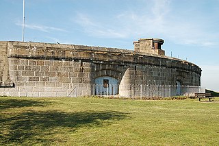
Fort Gilkicker is a historic Palmerston fort built at the eastern end of Stokes Bay, Gosport, Hampshire England to dominate the key anchorage of Spithead. It was erected between 1863 and 1871 as a semi-circular arc with 22 casemates, to be armed with five twelve-inch guns, seventeen ten-inch guns and five nine-inch guns. The actual installed armament rather differed from this. In 1902 the RML guns were replaced by two 9.2-inch and two six-inch BL guns, and before the First World War the walls were further strengthened with substantial earthwork embankments. The fort was disarmed in 1956 and used for storage until 1999, and is currently in a state of disrepair.

<span class="mw-page-title-main">Fort Southwick</span>

Fort Southwick is one of the forts found on Portsdown Hill, which overlooks the naval base of Portsmouth in the county of Hampshire, England.

<span class="mw-page-title-main">Fort Nelson, Hampshire</span> Palmerston fort in Boarhunt

Fort Nelson, in the civil parish of Boarhunt in the English county of Hampshire, is one of five defensive forts built on the summit of Portsdown Hill in the 1860s, overlooking the important naval base of Portsmouth. It is now part of the Royal Armouries, housing their collection of artillery, and a Grade I Listed Building.

<span class="mw-page-title-main">Fort Brockhurst</span> Historic fort in Gosport, England

Fort Brockhurst is one of the Palmerston Forts, in Gosport, England, and a Scheduled Ancient Monument. It is now an English Heritage property.

<span class="mw-page-title-main">Whitsand Bay</span>

Whitsand Bay, situated in south east Cornwall, England, runs from Rame Head in the east to Portwrinkle in the west. It is characterised by sheer, high cliffs, dramatic scenery and long stretches of sandy beaches. The South West Coast Path runs the length of the bay.

<span class="mw-page-title-main">Cliffe Fort</span> Disused military installation in Kent, England

Cliffe Fort is a disused artillery fort built in the 1860s to guard the entrance to the Thames from seaborne attack. Constructed during a period of tension with France, it stands on the south bank of the river at the entrance to Cliffe Creek in the Cliffe marshes on the Hoo Peninsula in North Kent, England. Its location on marshy ground caused problems from the start and necessitated changes to its design after the structure begin to crack and subside during construction. The fort was equipped with a variety of large-calibre artillery guns which were intended to support two other nearby Thamesside forts. A launcher for the Brennan torpedo—which has been described as the world's first practical guided missile—was installed there at the end of the 19th century but was only in active use for a few years.

<span class="mw-page-title-main">Fort Gomer</span>

Fort Gomer was one of the Palmerston Forts, in Gosport, England, the southernmost and first-built Polygonal fort in the defence line to the west of Gosport. It was located on land immediately to the west of the present Gomer Lane. Fort Gomer was the most southerly fort in the line of five which formed part of the ‘Sea Front and Spithead Defences’, Inner Line, Land Front, Left Flank. This line of forts was later known as the Gomer-Elson Line or 'Gosport Advanced Line' This consisted of, from south to north, Fort Gomer, Fort Grange, Fort Rowner, Fort Brockhurst and Fort Elson. An inscription above the main entrance through the barrack block read `Erected AD 1853’. The fort was almost complete before work began on Fort Elson in 1855. The estimated cost of Fort Gomer was £92,000 in 1869.

<span class="mw-page-title-main">Séré de Rivières system</span> Fortifications in France

The Séré de Rivières system was named after Raymond Adolphe Séré de Rivières, its originator. The system was an ensemble of fortifications built from 1874 along the frontiers and coasts of France. The fortresses were obsolescent by 1914 but were used during the First World War.

<span class="mw-page-title-main">Fort Glanville Conservation Park</span> Protected area in South Australia

Fort Glanville Conservation Park is a protected area located in the Australian state of South Australia located in Semaphore Park, a seaside suburb of Adelaide consisting of a functional 19th century fort listed on the South Australian Heritage Register and some adjoining land used as a caravan park. The fort was built after more than 40 years of indecision over the defence of South Australia. It was the first colonial fortification in the state and is the best preserved and most functional in Australia. Fort Glanville was designed by Governor Major General Sir William Jervois and Lieutenant Colonel Peter Scratchley, both important figures in early Australian colonial defence. When built it was designed to defend both Semaphore's anchorage and shipping entering the Port River from naval attack.

<span class="mw-page-title-main">Fort Rowner</span> Palmerston Fort in Gosport

Fort Rowner is one of the Palmerston Forts, in Gosport, England.

<span class="mw-page-title-main">Stokes Bay Lines</span>

The Stokes Bay Lines were part of the great Victorian fortification of Portsmouth Harbour under Lord Palmerston. In 1857 Major Jervois had proposed a complex system of moats (ditches), ramparts and batteries to close off the gap between the new fort at Fort Gomer, and the earlier fort at Fort Gilkicker, and Fort Monckton. This defensive moat was to become the ‘Stokes Bay Lines’.

<span class="mw-page-title-main">Fort Monckton</span>

Fort Monckton is a historic military fort on the south-east shoreline of the Gosport peninsula, Hampshire. Built on the ruins of Haselworth Castle to protect Portsmouth Harbour at the start of the American War of Independence, it was rebuilt in the 1880s as a Palmerston fort.

Fort Elson was one of the early Palmerston Forts, in Gosport, England, the northernmost polygonal land fort in the defence line to the west of Gosport. It was located on land immediately to the south of Elson Creek, to which it was connected by a sluice. Fort Elson was the most northerly fort in the line of five which formed part of the ‘Sea Front and Spithead Defences’, Inner Line, Land Front, Left Flank. This line of forts was later known as the Gomer-Elson Line or 'Gosport Advanced Line' This consisted of, from south to north, Fort Gomer, Fort Grange, Fort Rowner, Fort Brockhurst and Fort Elson. Work began on Fort Elson in 1855. The estimated cost of Fort Elson was £63,740 with the actual cost £61,180.

<span class="mw-page-title-main">1st Wessex Artillery</span> Military unit

The 1st Wessex Artillery was a volunteer unit of the British Army that existed under various titles from 1860 to 1971, including active service in Mesopotamia in World War I and North Africa and Italy in World War II.

<span class="mw-page-title-main">Fort Davis, County Cork</span>

Fort Davis, is a coastal defence fortification close to Whitegate, County Cork, Ireland. Together with similar structures at Fort Mitchel, Fort Camden (Crosshaven), and Templebreedy Battery, the fort was built to defend the mouth of Cork Harbour. Though used as a fortification from the early 17th century, the current structures of the 74-acre site date primarily from the 1860s. Originally named Fort Carlisle and operated by the British Armed Forces, the fort was handed-over to the Irish Defence Forces in 1938, and renamed Fort Davis. The facility is owned by the Department of Defence, and is used as a military training site with no public access.

References

  1. The Report of the Commissioners appointed to consider the defences of the United Kingdom together with the minutes of evidence, appendices and correspondence relating to the site of an internal arsenal.22.08.59 & various appendixes.
  2. Historic England. "Details from listed building database (1094240)". National Heritage List for England . Retrieved 1 October 2015.
  3. National Archive Plans of Fort Fareham held in WO78/ 3670 and WORK 43/240 to 244
  4. National Archive: Defence Committee Report dated 16/02/1867
  5. Report of the Committee appointed to enquire into the construction, condition and cost of fortifications erected in 30/31 Victoria statutes, together with minutes of evidence, 1868.
  6. National Archive:1876 1876 Proposed Armaments of Rifled guns for Land Front (not yet armed)
  7. National Archive: Proposal for Revised Armaments submitted by the Director of Artillery and Inspector General of Fortifications to the Defence Committee Table A 1886
  8. National Archive Armament return Dated 1902 held in WO33
  9. National Archive: Portsmouth Fortress Defence Scheme Revised November 1905 held in WO33/383
  10. http://www.victorianforts.co.uk/rga.htm Manning the Portsmouth Forts retrieved 05/02/2012
  11. National Archive: Plans of Fort Fareham op cit
  12. Rinaldi, Richard A, 2008. Order of Battle of the British Army 1914, Ravi Rikhye, p271
  13. National Archive: Fort Fareham Fort Record Book with 35AA Brigade Fort Fareham defence Scheme held in WO166/7392
  14. Solent papers No.7: Fort Fareham by David Moore page 24 ISBN   0-9513234-8-2
50°50′25″N1°11′18″W / 50.840352°N 1.188293°W / 50.840352; -1.188293