Fort Henry National Historic Site

Last updated

Fort Henry National Historic Site
Fort Henry Logo.png
Fort Henry National Historic Site
LocationPoint Henry, Kingston, Ontario, Canada
EstablishedFirst fort: 1812–1814
Second fort: 1832–1836
Owned byGovernment of Canada (Parks Canada), Operated by Ontario Ministry of Heritage, Sport, Tourism and Culture Industries (St Lawrence Parks Commission)
Managed byKathryn Lowe
DesignationNational Historic Site of Canada
Website http://www.forthenry.com
Designated1936

Fort Henry National Historic Site is located in Kingston, Ontario, Canada on Point Henry, a strategic, elevated point near the mouth of the Cataraqui River where it flows into the St. Lawrence River at the east end of Lake Ontario. The fort and the point on which the fort was built were named after Henry Hamilton, former Lieutenant-Governor of the Province of Quebec. [1]

Contents

A fortification was constructed during the War of 1812 to protect the Kingston Royal Naval Dockyard (the site of the present-day Royal Military College of Canada) on Point Frederick from a possible American attack during the war and to monitor maritime traffic on the St. Lawrence River and Lake Ontario. [2] [ page needed ] A much larger fort replaced this construction in the 1830s to maintain protection of the naval dockyard and protect the southern entrance to the Rideau Canal. The fort was restored in the 1930s and is a significant tourist attraction.

History

Background

In the years immediately following the American Revolution, British-American hostilities still concerned the British, and the high promontory of Point Henry was considered to be a good location for a defensive fortification. However, a fortification was not built on the hill until the beginning of the War of 1812.

In 1783, the British military established a post in what is now Kingston by partly refurbishing and garrisoning the ruined French fort (Fort Frontenac). The garrison and the developing townsite near the fort were deemed difficult to defend and so Captain John Ross, the British officer in charge of settling Loyalist refugees in the area, proposed moving the stronghold along with the townsite to the more defensible Point Henry. [3]

In 1794, Lord Dorchester ordered the survey of Point Henry, Point Frederick, and "the adjacent Country and Coves taking in whatever may lye near enough to affect the Security or convenience of the Port" to investigate the location of a navy base. Lt. Alexander Bryce of the Royal Engineers preferred Haldimand Cove (now Navy Bay) as a navy base and recommended a fortification on Point Henry to defend it. [4]

Early fortification

In November 1812, batteries from the Point Henry helped repel American warships pursuing HMS Royal George. Royal George Kingston Harbour.jpg
In November 1812, batteries from the Point Henry helped repel American warships pursuing HMS Royal George.

At the beginning of the War of 1812, local militia erected a blockhouse and battery on Point Henry to defend the important naval base on Point Frederick, located across Haldimand Cove to the west, and to monitor maritime traffic on the St. Lawrence River and Lake Ontario. [2] [ page needed ] On November 10, 1812, this battery was involved in repelling several American warships that were attacking the Provincial Marine sloop Royal George as the ship was taking refuge in Kingston Harbour. [2] [ page needed ] [5] This naval action strengthened the view that a stronger fortification was needed and so the militia and regular army began building batteries and barracks in 1813. [2] [ page needed ] The fort was one of several defensive structures built in and around Kingston during the war.

By 1820 the fort consisted of earth and stone ramparts, demi-bastions, redans, ditches, magazines, barracks, signal towers and support batteries. [2] [ page needed ] [6] [7]

Second fort

Completed in 1836, the second Fort was used by the British Army until 1871, and the Canadian Militia until 1891. Fort Henry, Kingston.jpg
Completed in 1836, the second Fort was used by the British Army until 1871, and the Canadian Militia until 1891.

Distrust between the Americans and British continued after the War of 1812. This led to the original fort being demolished to make way for a more extensive fort, which was constructed between 1832 and 1836 [8] [9] to defend the Lake Ontario end of the strategic Rideau Canal, the harbour, and the naval dockyard. In 1843, the advanced battery overlooking the lake to the south was completed when the casemated commissariat stores and magazines were built. These stone buildings connected the advanced battery to the main redoubt. A system of more elaborate defensive works was planned but cost overruns in the construction of the canal limited the fortifications to four Martello towers and the fort itself. At the time, these fortifications were the strongest defences in Canada west of Quebec City. Neither the original nor the second Fort Henry was ever attacked. The fort was once referred to as the "Citadel of Upper Canada".

Imperial (British) troops were deployed at the site of Fort Henry from 1813 to 1870. The Canadian Militia then garrisoned the fort until 1891. British garrisons included the Royal Regiment of Artillery, 24th Regiment of Foot, Black Watch, the Argyll and Sutherland Highlanders, the Royal Welch Fusiliers and the Royal Canadian Rifle Regiment. Canadian units who used the fort include "A" and "B' Batteries of Garrison Artillery, and the 14th Battalion, Princess of Wales' Own Rifles. As relations with the United States continued to improve, the need for defences along the border ceased. Abandoned by the military, the fort fell into disrepair.

Fort Henry temporarily held prisoners of the 1837–38 Rebellions. German, Austrian and Turkish prisoners of war and some civilians, including Ukrainian immigrants described as "enemy aliens" during Canada's first national internment operations of 1914–1920 were also held at the fort. During the Second World War, the fort served as a prisoner of war camp for German Luftwaffe and Kriegsmarine personnel.

Present use

A Martello tower at the water's edge below the fort. A removable roof to protect against snow is characteristic of Canadian Martello towers. Fort Henry Kingston Ontario 3.jpg
A Martello tower at the water's edge below the fort. A removable roof to protect against snow is characteristic of Canadian Martello towers.

In the 1930s, under the leadership of Ronald L. Way, restorations took place as part of a government work program during the Great Depression. "Old Fort Henry" became a living museum with the introduction of the Fort Henry Guard, and was opened on August 1, 1938.

Guards at Fort Henry, Kingston, 1951 Guards at Fort Henry, Kingston (I0005501).tif
Guards at Fort Henry, Kingston, 1951
Fort Henry Guard, the Goat Boy, and women in period costume at Fort Henry, 1957 Fort Henry Guard, the Goat Boy, and women in period costume at Fort Henry (I0005568).tif
Fort Henry Guard, the Goat Boy, and women in period costume at Fort Henry, 1957

Fort Henry is administered by Parks Canada and operated by the St. Lawrence Parks Commission. Uniformed military interpreters known as the Fort Henry Guard conduct demonstrations of British military life and tours for visitors. The Fort Henry Guard has a long history in itself. The Guard, founded in 1938 has been integral to the Fort's ability to maintain the spirit of 1867 life and the preservation of the fort. The Guard is not exclusive to military interpreters but includes domestic interpreters as well. Self-guided tours are also available. Other activities and demonstrations include historical reenactments of drills and battle tactics, the Garrison Parade, the Victorian School Room, and the Muster Parade, where young visitors are dressed in period uniforms and taught to march by a qualified member of the Guard. A Sunset Ceremony is held every Wednesday in July and August, where a full program of historic drill, music and artillery is presented. During evenings year-round a tour company conducts tours of the fort that highlight the fort's supposedly haunted past.

Fort Henry has been designated as a National Historic Site of Canada, and in 2007 was included in the designation of the Rideau Canal as a UNESCO World Heritage Site.

Legacy

On 30 June 1983 Canada Post issued 'Fort Henry, Ont.' in the "Forts Across Canada Series" (1983 and 1985). The stamps are based on the designs by Rolf P. Harder. [10]

See also

Related Research Articles

<span class="mw-page-title-main">Kingston, Ontario</span> City in Ontario, Canada

Kingston is a city in Ontario, Canada, on the northeastern end of Lake Ontario. It is at the beginning of the St. Lawrence River and at the mouth of the Cataraqui River, the south end of the Rideau Canal. Kingston is midway between Toronto, Ontario, and Montreal, Quebec, and is also near the Thousand Islands, a tourist region to the east, and the Prince Edward County tourist region to the west. Kingston is nicknamed the "Limestone City" because it has many heritage buildings constructed using local limestone.

<span class="mw-page-title-main">Fort York</span> Historic British garrison in Toronto, Canada

Fort York is an early 19th-century military fortification in the Fort York neighbourhood of Toronto, Ontario, Canada. The fort was used to house members of the British and Canadian militaries, and to defend the entrance of the Toronto Harbour. The fort features stone-lined earthwork walls and eight historical buildings within them, including two blockhouses. The fort forms a part of Fort York National Historic Site, a 16.6 ha (41-acre) site that includes the fort, Garrison Common, military cemeteries, and a visitor centre.

<span class="mw-page-title-main">Fort Frontenac</span> French fort in Kingston, Ontario, Canada

Fort Frontenac was a French trading post and military fort built in July 1673 at the mouth of the Cataraqui River where the St. Lawrence River leaves Lake Ontario, in a location traditionally known as Cataraqui. It is the present-day location of Kingston, Ontario, Canada. The original fort, a crude, wooden palisade structure, was called Fort Cataraqui but was later named for Louis de Buade de Frontenac, Governor of New France who was responsible for building the fort. It was abandoned and razed in 1689, then rebuilt in 1695.

<span class="mw-page-title-main">Murney Tower</span> Defensive tower built to protect Kingston, Ontario from American threats

Murney Tower is a Martello tower in Kingston, Ontario, Canada, whose construction dates to January 1846. The Tower was built in response to the Oregon Crisis, which was a tense dispute over the border between British North America and the United States in the 1840s.

HMS <i>Royal George</i> (1809) 1809 sloop-of-war

HMS Royal George was a British 20-gun wooden sloop of the Provincial Marine, and subsequently, the Royal Navy, operating on Lake Ontario during the War of 1812. The vessel took part in several Engagements on Lake Ontario and was the flagship of the Provincial Marine at the First Battle of Sackett's Harbor. In 1814, the vessel was renamed Niagara. Following the war, the sloop was converted to a transport and sold in 1837.

The Hon. Richard Cartwright was a businessman, judge and political figure in Upper Canada.

<span class="mw-page-title-main">Kingston Royal Naval Dockyard</span>

The Kingston Royal Naval Dockyard was a Royal Navy Dockyard from 1788 to 1853 in Kingston, Ontario, Canada, at the site of the current Royal Military College of Canada.

<span class="mw-page-title-main">Fort Wellington</span> Historic site in Ontario, Canada

Fort Wellington National Historic Site is a historic military fortification located on the north shore of the St. Lawrence River at Prescott, Ontario. The military fortification was used by the British Army, and the Canadian militia for most of the 19th century, and by the militia in the 20th century, until 1923, when the property was handed over to the Dominion Parks Commission, the predecessor to Parks Canada. The fort was earlier named a National Historic Site of Canada in January 1920.

<span class="mw-page-title-main">Fort Henry Guard</span> Historical demonstration military unit in Kingston, Ontario

The Fort Henry Guard (FHG) is a historical interpretation and exhibition drill organization based at Fort Henry, a national historic site in Kingston, Ontario, Canada. It has recreated the British military tradition of a bygone era since its founding in 1938. The Guard seeks to interpret in an entertaining and animated manner, a snapshot of life in the British Army of Queen Victoria, when Canada was part of the British Empire. The Guard also practices and performs historic military drill, demonstrated during daily inspections, cannon firings and garrison parades in addition to the weekly Sunset Ceremonies. Guard members dress in the standard line infantry uniforms of a British regiment and the standard gunner's uniforms of the Royal Artillery in the year 1867, but the Guard does not represent any specific infantry regiment that garrisoned the fort.

<span class="mw-page-title-main">Fort Frederick (Kingston, Ontario)</span> UNESCO World Heritage Site

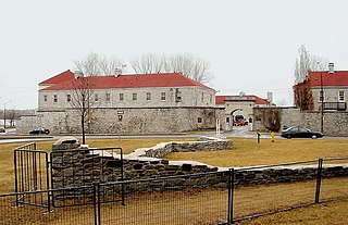
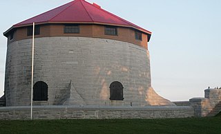
Fort Frederick is a historic military building located on Point Frederick on the grounds of the Royal Military College of Canada (RMC) in Kingston, Ontario, Canada. Its construction dates to 1846 and the Oregon boundary dispute. The fort consists of earthworks surrounding a Martello tower. Fort Frederick is included in two separate National Historic Sites of Canada: Kingston Fortifications National Historic Site and the Point Frederick Buildings National Historic Site.

<span class="mw-page-title-main">Provincial Marine</span> North American inland coastal protection service 1796–1910

Provincial Marine was a coastal protection service in charge of the waters in the Great Lakes, the St. Lawrence River and parts of Lake Champlain under British control. While ships of the Provincial Marine were designated HMS, they were operated in more of a coast guard manner than as a full-fledged navy. Operations were maintained and staffed by the Royal Navy. Most ships of the Provincial Marine were built on the Great Lakes.

Carleton Island is located in the St Lawrence River in upstate New York. It is part of the Town of Cape Vincent, in Jefferson County.

<span class="mw-page-title-main">Cathcart Tower</span> UNESCO World Heritage Site

Cathcart Tower is a Martello tower located on Cedar Island in the St. Lawrence River, off the eastern shore of Fort Henry in Kingston, Ontario, Canada. It is one of four such towers built in the 1840s to protect Kingston's harbour and the entrance to the Rideau Canal. The other towers are: Fort Frederick, Shoal Tower, and Murney Tower. Alexander Mackenzie was a foreman on the construction of the Carthcart Tower and later went on to become Canada's second prime minister 1873–1878. It was his work crew whose boat capsized while returning from Cedar Island, drowning 17 men. Hamilton Cove was subsequently renamed Deadman's Bay.

Kingston Mills, located approximately 7 kilometres (4.3 mi) north of downtown Kingston, Ontario, is the southernmost lockstation and one of 24 lockstations of the Rideau Canal system. Kingston Mills is a component of the Rideau Canal National Historic Site, and along with the rest of the Rideau Canal, is a World Heritage Site. The site is managed and operated by Parks Canada.

<span class="mw-page-title-main">Royal Military College of Canada Museum</span>

The Royal Military College of Canada Museum, established in 1962, is located in a Martello tower known as Fort Frederick on the campus of the Royal Military College of Canada in Kingston, Ontario, and is operated by the college. Until 2016 the museum had regular hours from the last weekend in June until Labour Day. Although admission was free, donations were accepted. Guided tours were offered in English and French. Genealogical research and archival records services were offered relating to college history or with inquires relating to ex-cadets when permitted by privacy regulations.

<span class="mw-page-title-main">HMCS Stone Frigate</span>

HMCS Stone Frigate is a dormitory of the Royal Military College of Canada in Kingston, Ontario. Built to be a naval storehouse, it was converted to its present use in 1876 on the establishment of the college.

<span class="mw-page-title-main">Bermuda Garrison</span> British military post

The Bermuda Garrison was the military establishment maintained on the British Overseas Territory and Imperial fortress of Bermuda by the regular British Army and its local militia and voluntary reserves from 1701 to 1957. The garrison evolved from an independent company, to a company of Royal Garrison Battalion during the American War of Independence, and a steadily growing and diversifying force of artillery and infantry with various supporting corps from the French Revolution onwards. During the American War of Independence, the garrison in Bermuda fell under the military Commander-in-Chief of America. Subsequently, it was part of the Nova Scotia Command until 1868, and was an independent Bermuda Command from then until its closure in 1957.

Point Frederick is a 41-hectare (101-acre) peninsula in Kingston, Ontario, Canada. The peninsula is located at the south end of the Rideau Canal where Lake Ontario empties into the St. Lawrence River. Point Frederick is bounded by the Cataraqui River to the west, the St. Lawrence River to the south, and Navy Bay to the east. The peninsula is occupied by the Royal Military College of Canada (RMC). Several of the buildings located on Point Frederick and the site of the old naval dockyard are national historic sites. Fort Frederick, at the south end of the peninsula, is a feature of the Kingston Fortifications National Historic Site of Canada.

<span class="mw-page-title-main">Prospect Camp, Bermuda</span> Military installation manned by the Royal Garrison Artillery

Prospect Camp, also referred to as Prospect Garrison, was the main infantry camp of the Bermuda Garrison, the military force stationed in the Imperial fortress of Bermuda. It also contained Fort Prospect, Fort Langton, and Fort Hamilton, as well as being the base for mobile artillery batteries, manned by the Royal Artillery. Outlying parts of the camp were disposed of in the early decades of the Twentieth Century as the garrison in Bermuda was reduced. The core area, including the barracks, passed to the local government when the garrison was withdrawn in 1957.

<span class="mw-page-title-main">Imperial fortress</span> One of four key British colonial military outposts

Imperial fortress was the designation given in the British Empire to four colonies that were located in strategic positions from each of which Royal Navy squadrons could control the surrounding regions and, between them, much of the planet.

References

Citations

  1. Mecredy 2000, p. 88.
  2. 1 2 3 4 5 Cary 2003.
  3. Mika & Mika 1987, p. 180.
  4. Osborne & Swainson 2011, p. 48.
  5. The Discriminating General - The War of 1812 Retrieved March 19, 2015
  6. Osborne & Swainson 2011, p. 50.
  7. Tanya Grodzinski, The Vigilant Superintedance of the Entire District: The War of 1812 on the Upper St Lawrence River. Master of Arts Thesis, Royal Military College of Canada, July 2002, p. 82.
  8. Mika & Mika 1987, p. 68.
  9. Ontario Heritage Plaque - Fort Henry Archived 2015-09-24 at the Wayback Machine Retrieved September 02, 2015
  10. Canadian Postage Stamps - Fort Henry Retrieved December 19, 2017

Sources

  • Cary, Henry (2003). "Early Works: Preliminary Glimpses of the First Military Complex at Point Henry, Kingston, Ontario, 1812–1827" (PDF). Ontario Archaeology . Ontario Archaeological Society. 76: 4–22. Archived from the original (PDF) on 27 August 2022.
  • Mecredy, Stephen D. (2000). Fort Henry: An Illustrated History. James Lorimer and Company. ISBN   978-1550286311.
  • Mika, Nick; Mika, Helma (1987). Kingston: Historic City. Belleville, Ontario: Mika Publishing Company. ISBN   0-921341-06-7.
  • Osborne, Brian S.; Swainson, Donald (2011). Kingston: Building on the Past for the Future. Quarry Heritage Books. ISBN   1-55082-351-5.

Further reading

44°13′48.95″N76°27′34.85″W / 44.2302639°N 76.4596806°W / 44.2302639; -76.4596806