
Antigua and Barbuda is a sovereign island country in the West Indies. It lies at the conjuncture of the Caribbean Sea and the Atlantic Ocean in the Leeward Islands part of the Lesser Antilles.
The history of Antigua and Barbuda covers the period from the arrival of the Archaic peoples thousands of years ago to the present day. Prior to European colonization, the lands encompassing present-day Antigua and Barbuda were inhabited by three successive Amerindian societies. The island was claimed by England, who settled the islands in 1632. Under English/British control, the islands witnessed an influx of both Britons and African slaves migrate to the island. In 1981, the islands were granted independence as the modern state of Antigua and Barbuda.
Antigua and Barbuda's transport systems include both public and privately run services. Roads in the country are paved and follow a winding and gently sloping course connecting parishes to villages and communities. Driving is on the left-hand side. The speed limit is set at 40 mph, Traffic signs posted throughout main roads in Antigua and Barbuda allow for ease of commute, and with GPS coordinates posted throughout the country, the process of navigation has become even easier.
Sir James Beethoven Carlisle, GCMG is a dentist and the former Governor-General of Antigua and Barbuda. Selected by Vere Cornwall Bird, his term ended in June 2007, after 16 years in office.
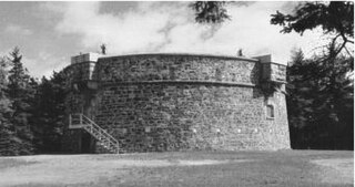
Martello towers, sometimes known simply as Martellos, are small defensive forts that were built across the British Empire during the 19th century, from the time of the French Revolutionary Wars onwards. Most were coastal forts.

Saint Paul is a civil parish of Antigua and Barbuda, located in the central−southern area of Antigua island. It had a population of 9,004 in 2018.
Saint John's or St. John's may refer to:

Antigua, also known as Waladli or Wadadli by the native population, is an island in the Lesser Antilles. It is one of the Leeward Islands in the Caribbean region and the most populous island of the country of Antigua and Barbuda. Antigua and Barbuda became an independent state within the Commonwealth of Nations on 1 November 1981.

Fort Saint Elmo is a star fort in Valletta, Malta. It stands on the seaward shore of the Sciberras Peninsula that divides Marsamxett Harbour from Grand Harbour, and commands the entrances to both harbours along with Fort Tigné and Fort Ricasoli. It is best known for its role in the Great Siege of Malta in 1565.

English Harbour is a natural harbour and settlement on the island of Antigua in the Caribbean, in the extreme south of the island. The settlement takes its name from the nearby harbour in which the Royal Navy established its base of operations for the area during the eighteenth century. Its population is 759.

Nelson's Dockyard is a cultural heritage site and marina in English Harbour, located in Saint Paul Parish on the island of Antigua, in Antigua and Barbuda.
The Attack on Saint Martin was a failed attempt by the Dutch Republic to recapture the island and former base of the Dutch West India Company (WIC) from the Spanish. In 1633 the Spanish had invaded Saint-Martin and Anguilla, driving off the French and Dutch inhabitants. The French and Dutch banded together to repel the Spanish and it was during a 1644 sea battle that the Dutch commander Peter Stuyvesant, later the governor of New Amsterdam, unsuccessfully besieged Fort Amsterdam and was forced to retreat with the loss of hundreds of men. A stray Spanish cannonball shattered his leg, which had to be amputated. But luck was on the Dutch side, and when the Eighty Years' War between Spain and the Netherlands ended, the Spanish no longer needed a Caribbean base and just sailed away in 1648.

Five Islands Village is a village located on the northwest coast of Antigua, within Saint John Parish in Antigua and Barbuda.

The fortifications of Valletta are a series of defensive walls and other fortifications which surround Valletta, the capital city of Malta. The first fortification to be built was Fort Saint Elmo in 1552, but the fortifications of the city proper began to be built in 1566 when it was founded by Grand Master Jean de Valette. Modifications were made throughout the following centuries, with the last major addition being Fort Lascaris which was completed in 1856. Most of the fortifications remain largely intact today.

Squatting in the island country of Antigua and Barbuda in the West Indies is the occupation of unused land or derelict buildings without the permission of the owner. Historically, native Barbudans were seen as squatters and after Hurricane Irma in 2017, Prime Minister Gaston Browne offered people he termed squatters the chance to buy their land.

Antigua and Barbuda and the United Kingdom of Great Britain and Northern Ireland (UK) are related through a long common history spanning from 1632 for Antigua, and 1678 for the smaller sister-isle of Barbuda through until 1981 for the joint-state. Antigua was one of the oldest English settlements in the West Indies, and served as a British hub of regional administration for the surrounding Leeward Islands.
Major divisions are the second level administrative divisions of Antigua and Barbuda.
Bridgetown, also known as Willoughby Bay, is a ghost town in Saint Philip, Antigua and Barbuda.

Fort Barrington is a historic military fort in Antigua and Barbuda. It is located on Goat Hill in St. John's, Antigua, at the western entrance to St. John's Harbor. The fort was built in 1779, and was named for Admiral Samuel Barrington. Remains of the fort include a circular battery, small magazine, and barracks.


