
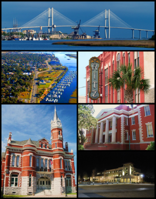
Savannah is the oldest city in the U.S. state of Georgia and the county seat of Chatham County. Established in 1733 on the Savannah River, the city of Savannah became the British colonial capital of the Province of Georgia and later the first state capital of Georgia. A strategic port city in the American Revolution and during the American Civil War, Savannah is today an industrial center and an important Atlantic seaport. It is Georgia's fifth most populous city, with a 2020 U.S. census population of 147,780. The Savannah metropolitan area, Georgia's third-largest, had a 2020 population of 404,798.

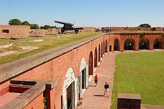
Fort McAllister was a Confederate earthen-work fort used to defend Savannah, Georgia during the American Civil War. It was the southernmost of the forts defending Savannah and was involved in the most battles. It was located on the Ogeechee River in Bryan County. It is listed on the National Register of Historic Places (#70000197). Fort McAllister was one of three forts protecting Savannah, the others being Fort Pulaski and Fort James Jackson standing in Confederate defiance of the Union naval blockade. The southeast coast of the United States was the place where both combatants tested the latest in naval artillery and coastal defenses. Fort McAllister was the key to unlocking the defenses around Savannah, one of the most important Confederate ports on the Atlantic Ocean.

Fort Frederica National Monument, on St. Simons Island, Georgia, preserves the archaeological remnants of a fort and town built by James Oglethorpe between 1736 and 1748 to protect the southern boundary of the British colony of Georgia from Spanish raids. About 630 British troops were stationed at the fort.
Fort Pulaski National Monument is located on Cockspur Island between Savannah and Tybee Island, Georgia. It preserves Fort Pulaski, the place where the Union Army successfully tested rifled cannon in combat during the American Civil War in 1862, the success of which rendered brick fortifications obsolete. The fort was also used as a prisoner-of-war camp.
The Golden Isles of Georgia consist of barrier islands, and the mainland port cities of Brunswick and Darien, on the 100-mile-long coast of the U.S. state of Georgia on the Atlantic Ocean. They include St. Simons Island, Sea Island, Jekyll Island, Little St. Simons Island, Sapelo Island, Blackbeard Island, Historic Darien and Historic Brunswick. The islands are part of a long chain of barrier islands known as the "Sea Islands", located along the coasts of South Carolina, Georgia and northern Florida.

The siege of Fort Pulaski concluded with the Battle of Fort Pulaski fought April 10–11, 1862, during the American Civil War. Union forces on Tybee Island and naval operations conducted a 112-day siege, then captured the Confederate-held Fort Pulaski after a 30-hour bombardment. The siege and battle are important for innovative use of rifled guns which made existing coastal defenses obsolete. The Union initiated large-scale amphibious operations under fire.
The city of Savannah, Province of Georgia, was laid out in 1733, in what was colonial America, around four open squares, each surrounded by four residential ("tything") blocks and four civic ("trust") blocks. The layout of a square and eight surrounding blocks was known as a "ward." The original plan was part of a larger regional plan that included gardens, farms, and "out-lying villages." Once the four wards were developed in the mid-1730s, two additional wards were laid. Oglethorpe's agrarian balance was abandoned after the Georgia Trustee period. Additional squares were added during the late 18th and 19th centuries, and by 1851 there were 24 squares in the city. In the 20th century, three of the squares were demolished or altered beyond recognition, leaving 21. In 2010, one of the three "lost" squares, Ellis, was reclaimed, bringing the total to today's 22.

The Savannah Historic District is a large urban U.S. historic district that roughly corresponds to the pre–Civil War city limits of Savannah, Georgia. The area was declared a National Historic Landmark District in 1966, and is one of the largest urban, community-wide historic preservation districts in the United States. The district was made in recognition of the Oglethorpe Plan, a unique sort of urban planning begun by James Oglethorpe at the city's founding and propagated for the first century of its growth.

The Owens–Thomas House & Slave Quarters is a historic home in Savannah, Georgia, that is operated as a historic house museum by Telfair Museums. It is located at 124 Abercorn Street, on the northeast corner of Oglethorpe Square. The Owens–Thomas House was designated a National Historic Landmark in 1976, as one of the nation's finest examples of English Regency architecture.
The city of Savannah, Georgia, the largest city and the county seat of Chatham County, Georgia, was established in 1733 and was the first colonial and state capital of Georgia. It is known as Georgia's first planned city and attracts millions of visitors, who enjoy the city's architecture and historic structures such as the birthplace of Juliette Gordon Low, the Telfair Academy of Arts and Sciences, the First African Baptist Church, Congregation Mickve Israel, and the Central of Georgia Railway roundhouse complex. Today, Savannah's downtown area is one of the largest National Historic Landmark Districts in the United States.

The protected areas of Georgia cover almost one million acres (4,000 km2) of the state. These areas are managed by different federal and state level authorities and receive varying levels of protection. Some areas are managed as wilderness while others are operated with acceptable commercial exploitation. On the Federal level, Georgia contains 1 Biosphere Reserve, 15 National Park Service Managed Sites, 1 National Forest and 8 Wildlife Refuges. Georgia is home to 63 state parks, 48 of which are state parks and 15 that are National Historic Sites, and many state wildlife preserves, under the supervision of the Georgia Department of Parks and Recreation, a division of the Georgia Department of Natural Resources.

The Georgia State Railroad Museum is a museum in Savannah, Georgia located at a historic Central of Georgia Railway site. It includes parts of the Central of Georgia Railway: Savannah Shops and Terminal Facilities National Historic Landmark District. The complex is considered the most complete antebellum railroad complex in the United States. The museum, located at 655 Louisville Road, is part of a historic district included in the National Register of Historic Places.

Central of Georgia Depot and Trainshed is a former passenger depot and trainshed constructed in 1860 by the Central of Georgia Railway (CofG) before the outbreak of the American Civil War. This pair of buildings was declared a National Historic Landmark in 1976, a listing that was expanded in 1978 to the old Central of Georgia Railway Savannah Shops and Terminal Facilities.

William Scarbrough House is a historic house in Savannah, Georgia. Built in 1819, and subjected to a number later alterations, it is nationally significant as an early example of Greek Revival architecture, and is one of the few surviving American works of architect William Jay. The house was declared a National Historic Landmark in 1973. It is now home to the Ships of the Sea Maritime Museum, and it has largely been restored to an early 19th-century appearance.

The Wormsloe Historic Site, originally known as Wormsloe Plantation, is a state historic site near Savannah, Georgia, in the southeastern United States. The site consists of 822 acres (3.33 km2) protecting part of what was once the Wormsloe Plantation, a large estate established by one of Georgia's colonial founders, Noble Jones. The site includes a picturesque 1.5 miles (2.4 km) oak avenue, the ruins of Jones' fortified house built of tabby, a museum, and a demonstration area interpreting colonial daily life.
The following is a timeline of the history of Savannah, Georgia, United States.

William Morrill Wadley was a railroad engineer, and the superintendent of several railroad projects in the Southern United States in the mid-19th century.

Jefferson Street is a prominent street in Savannah, Georgia, United States. Located between Montgomery Street to the west and Barnard Street to the east, it runs for about 2 miles (3.2 km) from West Bay Street in the north to West 42nd Street in the south. Its course was interrupted by around 0.14 miles (0.23 km) by the construction of the Savannah Civic Center in 1974. The street is named for Thomas Jefferson, third president of the United States. Its northern section passes through the Savannah Historic District, a National Historic Landmark District.
Oglethorpe Avenue is a prominent street in Savannah, Georgia, United States. Located, in its downtown section, between York Street to the north and Hull Street to the south, it runs for about 1.26 miles (2.03 km) from the Atlantic Coastal Highway in the west to Randolph Street in the east. It was originally known as South Broad Street, then Market Street. After being named South Broad Street again for a period, it became known as Oglethorpe Avenue in 1897. It was formerly Oglethorpe Avenue singular, but its addresses are now split between "West Oglethorpe Avenue" and "East Oglethorpe Avenue", the transition occurring at Bull Street in the center of the downtown area. The street is named for the founder of the Savannah colony, James Edward Oglethorpe.


