
Fort Niagara, also known as Old Fort Niagara, is a fortification originally built by New France to protect its interests in North America, specifically control of access between the Niagara River and Lake Ontario, the easternmost of the Great Lakes. The fort is on the river's eastern bank at its mouth on Lake Ontario. Youngstown, New York, later developed nearby.

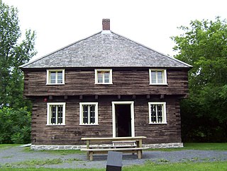
Port-Royal National Historic Site is a National Historic Site located on the north bank of the Annapolis Basin in Granville Ferry, Nova Scotia, Canada. The site is the location of the Habitation at Port-Royal, which was the centre of activity for the French colony of Port Royal in Acadia from 1605 to 1613 when it was destroyed by English forces from the Colony of Virginia.
Beaubassin was an important Acadian village and trading centre on the Isthmus of Chignecto in what is now Nova Scotia, Canada. The area was a significant place in the geopolitical struggle between the British and French empires. It was established in the 1670s on an upland close to an extensive area of saltwater marsh. Settlers reclaimed the land to engage in cattle ranching and trade.
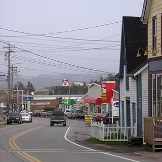
St. Peter's is a small incorporated village located on Cape Breton Island in Richmond County, Nova Scotia, Canada.

Fort La Reine was built in 1738 and is one of the forts of the western expansion directed by Pierre Gaultier de Varennes et de La Vérendrye, first military commander in the west of what is now known as Canada. Located on the Assiniboine River where present day Portage la Prairie, Manitoba, stands, the fort served as a fur trading post. It was also the base of operations for much exploration north and west. From Fort La Reine, explorers made their way to Lake Manitoba and Lake Winnipegosis, Lake Winnipeg and the Saskatchewan River.

Crown Point State Historic Site is the site of a former military stronghold at the south end of the wider part of Lake Champlain. The location is in Essex County, New York, United States. The site is on a peninsula in the town of Crown Point, New York.

Île aux Noix is an island on the Richelieu River in Quebec, close to Lake Champlain. The island is the site of Fort Lennox National Historic Site of Canada. Politically, it is part of Saint-Paul-de-l'Île-aux-Noix.

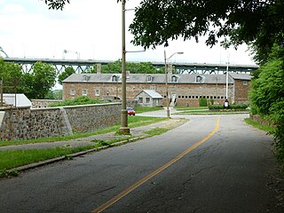
Fort Lennox is a National Historic Sites of Canada occupying most of Île aux Noix, an island in the middle of the Richelieu River in the parish of Saint-Paul-de-l'Île-aux-Noix, Quebec, near the Canada-U.S. border. The fort features restored defence works and stonework buildings, and is surrounded by a star-shaped moat. It is owned by the Government of Canada and managed by Parks Canada
Fort Rouge was a fort located on the Assiniboine River in Manitoba, Canada, on the site of what is now the city of Winnipeg. Its exact location is unknown. Its name in English means "red fort".

During the 18th and early 19th centuries, the French, British and U.S. forces built and occupied a number of forts at Vincennes, Indiana. These outposts commanded a strategic position on the Wabash River. The names of the installations were changed by the various ruling parties, and the forts were considered strategic in the French and Indian War, the American Revolutionary War, the Northwest Indian War and the War of 1812. The last fort was abandoned in 1816.
The Saint Helen Island Fort, a historic site on Saint Helen's Island in the city of Montreal, Quebec, was constructed in the early 1820s as an arsenal in the defensive chain of forts built to protect Canada from a threat of American invasion. Although not heavily fortified, it served an important purpose as the central artillery depot for all forts west, and in the Richelieu River Valley, known as the Valley of the Forts. These included Fort Henry and Fort Lennox. The red stone used to build the Fort is a breccia quarried on the island, which is situated in the St. Lawrence River between the island of Montreal and the south shore.

Fort Richelieu is a historic fort in La Vallée-du-Richelieu Regional County Municipality, Quebec, Canada. The fort is designated as a National Historic Site of Canada. Fort Richelieu was part of a series of five forts built along the Richelieu River and is at the mouth of the Richelieu River. Fort Chambly formerly known as Fort St. Louis at Chambly, Fort Sainte-Thérèse, and Fort Saint-Jean at Saint-Jean-sur-Richelieu, are on the way. Fort Sainte Anne (Vermont) on Isle La Motte, Vermont in Lake Champlain is near its source. The forts were built in order to protect travellers on the river from the Iroquois. The region is informally known as la Vallée-des-Forts.

The Battle of La Prairie was an attack made on the French colonial settlement of La Prairie, New France on August 11, 1691 by an English, Mohawk and Mohican force coming north from Albany, New York. The force, led by Major Pieter Schuyler, initially intended to attack Montreal, but was repulsed with significant casualties by the French and their Indian allies.
Lacolle Mills Blockhouse is a blockhouse and museum located alongside the Lacolle River near the village of Lacolle, Quebec.

Skmaqn–Port-la-Joye–Fort Amherst is a National Historic Site located in Rocky Point, Prince Edward Island.
Castle Hill is an area containing the remains of both French and British fortifications, overlooking the town of Placentia in Newfoundland and Labrador, Canada. The site was originally established in order to protect the French fishing interests in Terre-Neuve (Newfoundland) and the approaches to the French colony of Canada.

The Pays d'en Haut was a territory of New France covering the regions of North America located west of Montreal. The vast territory included most of the Great Lakes region, expanding west and south over time into the North American continent as the French had explored. The Pays d'en Haut was established in 1610 and depended on the colony of Canada until 1763, when the Treaty of Paris ended New France, and both were ceded to the British as the Province of Quebec.
Fort Boishébert is a National Historic Site at Woodmans Point outside the Town of Grand Bay–Westfield, Kings County, New Brunswick, Canada. Located at the confluence of the Saint John River and Nerepis rivers, the fort may have had its origins as a fortified aboriginal village. Joseph Robineau de Villebon noted this in a letter dated October 22, 1696, "Sr. de Neuvillette reported that he was continuing on his way down river and would, as he passed the fort of the Nerepis Indians..." Earlier in October 1696, French soldiers upon being rescued by Nerepis, retreated to Fort Nerepis after being attacked by a small English fleet that had entered Saint John Harbour.

Fort Sainte Thérèse is the name given to three different forts built successively on one site, among a series of fortifications constructed during the 17th century by France along the Richelieu River, in the province of Quebec, in Montérégie.

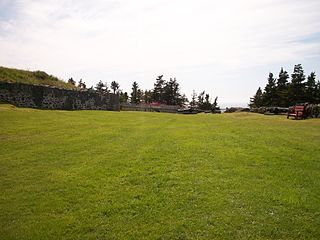
Fort Ste. Anne is a former French military fort located at present-day Englishtown, Nova Scotia, on the Island of Cape Breton, Nova Scotia, Canada.
