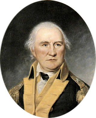
Daniel Morgan was an American pioneer, soldier, and politician from Virginia. One of the most respected battlefield tacticians of the American Revolutionary War of 1775–1783, he later commanded troops during the suppression of the Whiskey Rebellion of 1791–1794.
Fort Ontario is an American historic bastion fort situated by the City of Oswego in Oswego County, New York. It is owned by the state of New York and operated as a museum known as Fort Ontario State Historic Site.

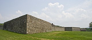
Fort de Chartres was a French fortification first built in 1720 on the east bank of the Mississippi River in present-day Illinois. It was used as the administrative center for the province, which was part of New France. Due generally to river floods, the fort was rebuilt twice, the last time in limestone in the 1750s in the era of French colonial control over Louisiana and the Illinois Country.

Fort Monroe is a former military installation in Hampton, Virginia, at Old Point Comfort, the southern tip of the Virginia Peninsula, United States. It is currently managed by partnership between the Fort Monroe Authority for the Commonwealth of Virginia, the National Park Service, and the city of Hampton as the Fort Monroe National Monument. Along with Fort Wool, Fort Monroe originally guarded the navigation channel between the Chesapeake Bay and Hampton Roads—the natural roadstead at the confluence of the Elizabeth, the Nansemond and the James rivers.
David Morgan, sometimes known as "The Great Indian Fighter", was a notable soldier, mountaineer, pioneer, and frontiersman in what is now the state of West Virginia.

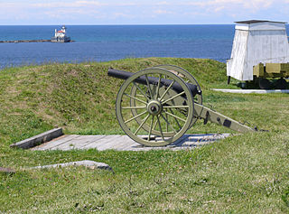
Fort Loudoun was a British fort located in what is now Monroe County, Tennessee. Constructed from 1756 until 1757 to help garner Cherokee support for the British at the outset of the French and Indian War, the fort was one of the first significant British outposts west of the Appalachian Mountains. The fort was designed by John William Gerard de Brahm, while its construction was supervised by Captain Raymond Demeré; the fort's garrison was commanded by Demeré's brother, Paul Demeré. It was named for the Earl of Loudoun, the commander of British forces in North America at the time.
Fort Frederick State Park is a public recreation and historic preservation area on the Potomac River surrounding the restored Fort Frederick, a fortification active in the French and Indian War (1754–1763) and the American Revolutionary War (1775-1783). The state park lies south of the town of Big Pool, Maryland. The Chesapeake and Ohio Canal runs through the park grounds. The site was designated a National Historic Landmark in 1973.

Fort McIntosh was an early American log frontier fort situated near the confluence of the Ohio River and the Beaver River in what is now Beaver, Pennsylvania.
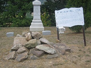
Fort Pearsall was an early frontier fort constructed in 1756 in Romney, West Virginia to protect local settlers in the South Branch Potomac River valley against Native American raids. The area around present-day Romney had been settled as early as 1725 by hunters and traders in the valley.

Waterford is an unincorporated village and census-designated place (CDP) in the Catoctin Valley of Loudoun County, Virginia, located along Catoctin Creek. Waterford is 47 miles (76 km) northwest of Washington, D.C., and 7 miles (11 km) northwest of Leesburg. The entire village and surrounding countryside is a National Historic Landmark District, noted for its well-preserved 18th and 19th-century character.
Arcola is a census-designated place in Loudoun County, Virginia, United States. The population as of the 2010 United States Census was 233.
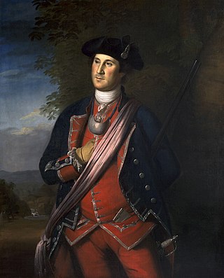
George Washington's military experience began in the French and Indian War with a commission as a major in the militia of the British Province of Virginia. In 1753 Washington was sent as an ambassador from the British crown to the French officials and Indians as far north as present-day Erie, Pennsylvania. The following year he led another expedition to the area to assist in the construction of a fort at present-day Pittsburgh, Pennsylvania. Before reaching that point, he and some of his men, along with Mingo allies led by Tanacharison, ambushed a French scouting party. Its leader was killed, although the exact circumstances of his death were disputed. This peacetime act of aggression is seen as one of the first military steps leading to the global Seven Years' War. The French responded by attacking fortifications Washington erected following the ambush, forcing his surrender. Released on parole, Washington and his troops returned to Virginia.
The city of Winchester, Virginia, and the surrounding area, were the site of numerous battles during the American Civil War, as contending armies strove to control the lower Shenandoah Valley. Winchester changed hands more often than any other Confederate city.

Adam Stephen was a Scottish-born American doctor and military officer who helped found what became Martinsburg, West Virginia. He emigrated to North America, where he served in the Province of Virginia's militia under George Washington during the French and Indian War. He served under Washington again in the American Revolutionary War, rising to lead a division of the Continental Army. After a friendly fire incident during the Battle of Germantown, Stephen was cashiered out of the army but continued as a prominent citizen of western Virginia, including terms in the Virginia General Assembly representing Berkeley County.

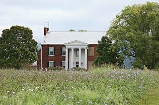
Ridgedale is a 19th-century Greek Revival plantation house and farm on a plateau overlooking the South Branch Potomac River north of Romney, West Virginia, United States. The populated area adjacent to Washington Bottom Farm is known as Ridgedale. The farm is connected to West Virginia Route 28 via Washington Bottom Road.
This is a list of the National Register of Historic Places listings in Winchester, Virginia.

Arlington Ridge is a neighborhood in Arlington County, Virginia, United States. It is bordered on the north by The Pentagon, on the west by the Army Navy Country Club, and on the south the City of Alexandria. The main thoroughfare is the eponymous Arlington Ridge Road, a mansion-lined boulevard that, due to its high elevation, offers picturesque views of Washington, D.C., and the surrounding areas.
Fort Pleasant — formerly known as Fort Van Meter and Town Fort and still also known as the Isaac Van Meter House — is a historic site located near the unincorporated community of Old Fields about 5 miles north of Moorefield in Hardy County, West Virginia, U.S. Situated on the South Branch Potomac River, a young Colonel George Washington directed a fortification to be built here in 1756 during the escalating hostilities with Native Americans and French known as the French and Indian War. The fierce skirmish known as the Battle of the Trough occurred about a mile and a half away the same year. The existing Federal style house, built just after the American Revolution, was listed on the National Register of Historic Places in 1973.

Ketoctin Baptist Church, also known as Short Hill Church, is a historic Baptist church located at Round Hill, Loudoun County, Virginia. It is listed on both the U.S. National Register of Historic Places and the Virginia Landmarks Register.

Adam Kurtz House, also known as Washington's Headquarters, is a historic home located at Winchester, Virginia. It was built about 1755, and is of hewn-log construction. It consists of three rooms, with the westernmost room having two of its three exterior walls of stone construction. It sits on a rubble limestone foundation.


