
Mackinac Island is an island and resort area, covering 4.35 square miles (11.3 km2) in land area, in the U.S. state of Michigan. The name of the island in Odawa is Michilimackinac and "Mitchimakinak" in Ojibwemowin meaning "Great Turtle". It is located in Lake Huron, at the eastern end of the Straits of Mackinac, between the state's Upper and Lower Peninsulas. The island was long home to an Odawa settlement and previous indigenous cultures before European colonization began in the 17th century. It was a strategic center of the fur trade around the Great Lakes. Based on a former trading post, Fort Mackinac was constructed on the island by the British during the American Revolutionary War. It was the site of two battles during the War of 1812 before the northern border was settled and the US gained this island in its territory.

Mackinac County is a county in the Upper Peninsula of the U.S. state of Michigan. As of the 2020 Census, the population was 10,834. The county seat is St. Ignace. Formerly known as Michilimackinac County, in 1818 it was one of the first counties of the Michigan Territory, as it had long been a center of French and British colonial fur trading, a Catholic church and Protestant mission, and associated settlement.

Emmet County is a county located in the U.S. state of Michigan. It is the northernmost county in the Lower Peninsula. As of the 2020 Census, the population was 34,112, making it the second-most populous county in Northern Michigan. The county seat is Petoskey, which is also the county's largest city.

St. Ignace is a city in the U.S. state of Michigan and the county seat of Mackinac County. The city had a population of 2,306 at the 2020 census. St. Ignace Township is located just to the north of the city, but the two are administered autonomously.

Mackinaw City is a village at the northernmost point of the Lower Peninsula of Michigan. Divided between Cheboygan and Emmet counties, Mackinaw City is the located at the southern end of the Mackinac Bridge, which carries Interstate 75 over the Straits of Mackinac to the Upper Peninsula. Mackinaw City, along with St. Ignace, serves as an access point to Mackinac Island. For these reasons, Mackinaw City is considered one of Michigan's most popular tourist attractions.
Mackinac or Mackinaw may refer to:

Wawatam was an 18th-century Odawa chief who lived in the northern region of present-day Michigan's Lower Peninsula in an area along the Lake Michigan shoreline known by the Odawa as Waganawkezee.

The Straits of Mackinac are the short waterways between the U.S. state of Michigan's Upper and Lower Peninsulas, traversed by the Mackinac Bridge. The main strait is 3+1⁄2 miles wide with a maximum depth of 295 feet, and connects the Great Lakes of Lake Michigan and Lake Huron. Given the large size and configuration of the straits, hydrologically, the two connected lakes are one body of water, studied as Lake Michigan–Huron. Historically, the native Odawa people called the region around the Straits Michilimackinac.

Fort Mackinac is a former British and American military outpost garrisoned from the late 18th century to the late 19th century in the city of Mackinac Island, Michigan, on Mackinac Island. The British built the fort during the American Revolutionary War to control the strategic Straits of Mackinac between Lake Michigan and Lake Huron, and by extension the fur trade on the Great Lakes. The British did not relinquish the fort until thirteen years after the end of the American Revolutionary War. Fort Mackinac later became the scene of two strategic battles for control of the Great Lakes during the War of 1812. During most of the 19th century, it served as an outpost of the United States Army. Closed in 1895, the fort has been adapted as a museum on the grounds of Mackinac Island State Park.
Mackinac Island State Park is a state park located on Mackinac Island in the U.S. state of Michigan. A Lake Huron island, it is near the Straits of Mackinac. The island park encompasses 1,800 acres (7.3 km2), which is approximately 80% of the island's total area. The park is also within the boundaries of the city of Mackinac Island and has permanent residents within its boundaries. M-185 circles the perimeter of the park as the only motorless highway in the state due to the island's ban of automobiles. The park is governed by the Michigan Department of Natural Resources and the Mackinac Island State Park Commission. On July 15, 2009, the park celebrated its 20 millionth visitor.
Michilimackinac is derived from an Ottawa Ojibwe name for present-day Mackinac Island and the region around the Straits of Mackinac between Lake Huron and Lake Michigan. Early settlers of North America applied the term to the entire region along Lakes Huron, Michigan, and Superior. Today it is considered to be mostly within the boundaries of Michigan, in the United States. Michilimackinac was the original name for present day Mackinac Island and Mackinac County.

Northern Michigan, also known as Northern Lower Michigan, is a region of the U.S. state of Michigan. A popular tourist destination, it is home to several small- to medium-sized cities, extensive state and national forests, lakes and rivers, and a large portion of Great Lakes shoreline. The region has a significant seasonal population much like other regions that depend on tourism as their main industry. Northern Lower Michigan is distinct from the more northerly Upper Peninsula and Isle Royale, which are also located in "northern" Michigan. In the northernmost 21 counties in the Lower Peninsula of Michigan, the total population of the region is 506,658 people.

Fort Michilimackinac State Park is a state park in the U.S. state of Michigan. It is located in Mackinaw City along the Straits of Mackinac. The park contains Fort Michilimackinac, which itself is dedicated a National Historic Landmark and Old Mackinac Point Lighthouse as well as the Old Mackinac Point Lighthouse Signal Tower which contains a foghorn.
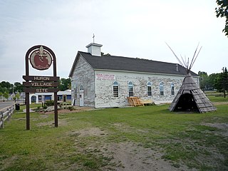
Fort de Buade was a French fort in the present U.S. state of Michigan's Upper Peninsula across the Straits of Mackinac from the northern tip of lower Michigan's "mitten". It was garrisoned between 1683 and 1701. The city of St. Ignace developed at the site, which also had the historic St. Ignace Mission founded by Jesuits. The fort was named after New France's governor at the time, Louis de Buade de Frontenac.

Chief Wawatam was a coal-fired steel ship that was based, for most of its 1911–1984 working life, in St. Ignace, Michigan. The vessel was named after a distinguished Ojibwa chief of the 1760s. In initial revenue service, the Chief Wawatam served as a train ferry, passenger ferry and icebreaker that operated year-round at the Straits of Mackinac between St. Ignace and Mackinaw City, Michigan. During the winter months, it sometimes took many hours to cross the five-mile-wide Straits, and Chief Wawatam was fitted with complete passenger hospitality spaces.

Old Mackinac Point Light is a deactivated lighthouse located at the northern tip of the Lower Peninsula in the U.S. state of Michigan. The lighthouse is part of Fort Michilimackinac State Park in the village of Mackinaw City just east of the Mackinac Bridge.

McGulpin Point Light was constructed as a navigational aid through the Straits of Mackinac. The light began operation in 1869, making it one of the oldest surviving lighthouses in the Straits. Only in operation until 1906, the light is located on McGulpin Point,, approximately 3 miles (4.8 km) west of Fort Michilimackinac.

Waugoshance Point is a 2.5-mile-long (4.0 km) cape or peninsula that juts into Lake Michigan from the northwest coast of the Lower Peninsula of the U.S. state of Michigan in Emmet County. It separates the Straits of Mackinac to its north from Sturgeon Bay to the south and is part of Wilderness State Park. The nearest town is Mackinaw City. Waugoshance is a hybrid word, that combines the Anishinaabemowin word wah'goosh and the French word anse.

Sainte Anne Church, commonly called 'Ste. Anne Church' or 'Ste. Anne's Church', is a Roman Catholic church that serves the parish of Sainte Anne de Michilimackinac in Mackinac Island, Michigan. The Jesuit missionary Claude Dablon inaugurated the rites of the Catholic faith on Mackinac Island in 1670, but the earliest surviving parish records list sacraments performed starting in April 1695. After moving from Fort de Buade to Fort Michilimackinac about 1708 and from Fort Michilimackinac to Mackinac Island in 1781, the parish used a historic log church for decades. It constructed the current church complex starting in 1874 on a site donated by the former fur trader, Magdelaine Laframboise.


