
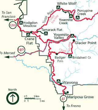
Yosemite National Park is a national park in California. It is bordered on the southeast by Sierra National Forest and on the northwest by Stanislaus National Forest. The park is managed by the National Park Service and covers 759,620 acres in four counties – centered in Tuolumne and Mariposa, extending north and east to Mono and south to Madera. Designated a World Heritage Site in 1984, Yosemite is internationally recognized for its granite cliffs, waterfalls, clear streams, giant sequoia groves, lakes, mountains, meadows, glaciers, and biological diversity. Almost 95 percent of the park is designated wilderness. Yosemite is one of the largest and least fragmented habitat blocks in the Sierra Nevada.
Yosemite Valley is a glacial valley in Yosemite National Park in the western Sierra Nevada mountains of Central California, United States. The valley is about 7.5 mi (12.1 km) long and 3,000–3,500 ft (910–1,070 m) deep, surrounded by high granite summits such as Half Dome and El Capitan, and densely forested with pines. The valley is drained by the Merced River, and a multitude of streams and waterfalls flow into it, including Tenaya, Illilouette, Yosemite and Bridalveil Creeks. Yosemite Falls is the highest waterfall in North America and is a big attraction, especially in the spring, when the water flow is at its peak. The valley is renowned for its natural environment and is regarded as the centerpiece of Yosemite National Park.

Wawona is a census-designated place in Mariposa County, California, United States. The population was 111 at the 2020 census.
Mariposa Grove is a sequoia grove located near Wawona, California, United States, in the southernmost part of Yosemite National Park. It is the largest grove of giant sequoias in the park, with several hundred mature examples of the tree. Two of its trees are among the 30 largest giant sequoias in the world. The grove closed on July 6, 2015, for a restoration project and reopened on June 15, 2018.

Human habitation in the Sierra Nevada region of California reaches back 8,000 to 10,000 years ago. Historically attested Native American populations, such as the Sierra Miwok, Mono and Paiute, belong to the Uto-Aztecan and Utian phyla. In the mid-19th century, a band of Native Americans called the Ahwahnechee lived in Yosemite Valley. The California Gold Rush greatly increased the number of non-indigenous people in the region. Tensions between Native Americans and white settlers escalated into the Mariposa War. As part of this conflict, settler James Savage led the Mariposa Battalion into Yosemite Valley in 1851, in pursuit of Ahwaneechees led by Chief Tenaya. The California state military forces burned the tribe's villages, destroyed their food stores, killed the chief's sons, and forced the tribe out of Yosemite. Accounts from the Mariposa Battalion, especially from Dr. Lafayette Bunnell, popularized Yosemite Valley as a scenic wonder.

The Wawona Hotel is a historic hotel located within southern Yosemite National Park, in California. It was declared a National Historic Landmark in 1987, and is on the National Register of Historic Places.

Badger Pass Ski Area is a small ski area located within Yosemite National Park. Badger Pass is one of only three lift serviced ski areas operating in a US National Park. It is situated five miles (8 km) south-southeast of the Chinquapin intersection of Wawona Road with Glacier Point Road in the southern area of Yosemite National Park. Glacier Point Road provides the access to this ski area. During high snow level and/or ski season, Glacier Point road terminates at Badger Pass Ski Resort. Under these conditions, the remainder of Glacier Point Road is used for cross-country skiing access to Glacier Point and other destinations in the high country.
Tunnel View is a scenic viewpoint on California State Route 41 in Yosemite National Park, United States. Visitors have seen and documented the iconic and expansive views of Yosemite Valley from the overlook since its opening in 1933.

The Chandelier Tree in Drive-Thru Tree Park is a 276-foot (84 m) tall coast redwood tree in Leggett, California with a 6-foot-wide (1.8 m) by 6-foot-9-inch-high (2.06 m) hole cut through its base to allow a car to drive through. Its base measures 16 ft (4.9 m) diameter at breast height (chest-high). A historic sign put up in or before the 1930s claims a height of 315 feet high and 21 feet wide, but a contemporary measurement by a Certified Arborist experienced with tall redwoods and using a laser rangefinder found the tree to be 276 feet high and 16 feet in diameter. It is unknown if the tree was topped by Nature in between the measurements.

Yosemite West is an unincorporated community of resort homes located just outside the southern area of Yosemite National Park, just off Wawona Road, a continuation of State Route 41 from Fresno. It is a census-designated place (CDP), with a population of 47 as of the 2020 census. It is situated one mile (1.6 km) south of the Chinquapin intersection of Wawona Road with Glacier Point Road, at an altitude of 5,100 to 6,300 feet. The elevation reported by the USGS is 5,866 feet (1,788 m). The community is part of Henness Ridge, nearly 3,000 feet (910 m) above the southern banks of the Merced River and State Route 140 from Mariposa. Addresses in this area are shown as "Yosemite National Park, CA 95389".

The Wawona Tree, also known as the Wawona Tunnel Tree, was a famous giant sequoia that stood in Mariposa Grove, Yosemite National Park, California, United States, until February 1969. It had a height of 227 feet (69 m) and was 26 feet (7.9 m) in diameter at the base.
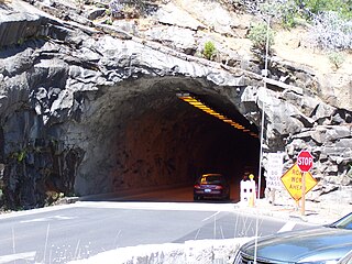
The Wawona Tunnel is a highway tunnel in Yosemite National Park. It, and Tunnel View just beyond its east portal, were completed in 1933.
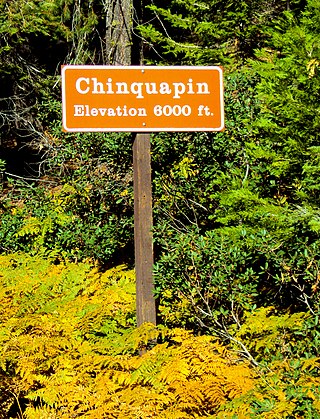
Chinquapin is a former settlement in Mariposa County, California. It was located 8.5 miles (14 km) north-northwest of Wawona. It is located within Yosemite National Park, adjacent to the community of Yosemite West. Chinquapin is the midway point between Yosemite Valley and Wawona, a community inside the park.

The Yosemite Valley Railroad (YVRR) was a short-line railroad that operated in California from 1907 to 1945, providing a new mode of travel and tourism for the region. It ran from Merced to the Yosemite National Park, but it did not extend to Yosemite Valley itself, as railroad construction was prohibited in the National Parks. Tourists would disembark at the park boundary in El Portal, California and stay overnight at the Hotel Del Portal before taking a stagecoach to Yosemite Valley.

George Frazier Monroe (c.1844-1886) was a stagecoach driver for the Pony Express. His passengers included presidents and a socialite.

The January 1997 flood of the Merced River occurred from December 31, 1996, to January 5, 1997, throughout the Yosemite Valley in Yosemite National Park, Mariposa County, California, US. The flood stands as arguably the park's worst natural disaster to date, and inarguably the worst flood in park history. The Merced River at Happy Isles peaked at 10,100 cubic feet per second during the flood. A book was written on the flood later in 1997 by Mark Goodin titled Yosemite: The 100-Year Flood.

The Wawona Covered Bridge is a covered bridge spanning the South Fork Merced River near Wawona, California, in Yosemite National Park. The open bridge was built by Galen Clark, the steward of what was then called the Yosemite Grant, in 1868, without its cladding. The open bridge was a component of Clark's proposed new road from Wawona to the Yosemite Valley. Clark was unable to complete the road, which he sold to the Washburn Group of investors along with his stopover lodging in 1874. In mid-1875 the Washburn Group completed the road to Yosemite Valley. It is one of twelve remaining covered bridges in California.

The Yosemite Transportation Company Office, also known as the Wells Fargo Office, was built in the Yosemite Valley in 1910 to house facilities of motor stage and horse stage services between the nearest rail terminal at El Portal and Yosemite National Park. The rustic log structure also provided telegraph and express services.
Vallecito, in San Diego County, California, is an oasis of cienegas and salt grass along Vallecito Creek and a former Kumeyaay settlement on the edge of the Colorado Desert in the Vallecito Valley. Its Spanish name is translated as "little valley". Vallecito was located at the apex of the gap in the Carrizo Badlands created by Carrizo Creek and its wash in its lower reach, to which Vallecito Creek is a tributary. The springs of Vallecito, like many in the vicinity, are a product of the faults that run along the base of the Peninsular Ranges to the west.

The Ferguson Fire was a major wildfire in the Sierra National Forest, Stanislaus National Forest and Yosemite National Park in California in the United States. The fire was reported on July 13, 2018, burning 96,901 acres (392 km2), before it was 100% contained on August 19, 2018. Interior areas of the fire continued to smolder and burn until September 19, 2018, when InciWeb declared the fire to be inactive. The Ferguson Fire was caused by the superheated fragments of a faulty vehicle catalytic converter igniting vegetation. The fire, which burned mostly in inaccessible wildland areas of the national forest, impacted recreational activities in the area, including in Yosemite National Park, where Yosemite Valley and Wawona were closed. The Ferguson Fire caused at least $171.2 million in damages, with a suppression cost of $118.5 million and economic losses measuring $52.7 million. Two firefighters were killed and nineteen others were injured in the fire.

