Fort Mountain (Murray County, Georgia)

Last updated

Fort Mountain GA
Fort Mountain, Murray County, Georgia December 2015.JPG
Fort Mountain, viewed from Chatsworth
Highest point
Elevation 2,850 ft (870 m)
Prominence 321 ft (98 m)
Coordinates 34°46′59″N84°42′33″W / 34.78306°N 84.70917°W / 34.78306; -84.70917
Geography
USA Georgia relief location map.svg
Red triangle with thick white border.svg
Fort Mountain GA
Usa edcp relief location map.png
Red triangle with thick white border.svg
Fort Mountain GA
Fort Mountain GA (the United States)
Nearest city Chatsworth, Georgia
Area211.2 acres (85.5 ha)
NRHP reference No. 77001587 [1]
Added to NRHPNovember 23, 1977

Fort Mountain is a mountain in northern Georgia, just east of Chatsworth. It is part of the Cohutta Mountains, a small mountain range at the southern end of the Appalachian Mountains. It also lies within the Chattahoochee National Forest.

Contents

A main feature of Fort Mountain is an ancient rock formation or ruin of unknown origin, from which the mountain takes its name. The site lies within Fort Mountain State Park and consists of a series of stone piles lying in a long uneven line that follows the contour of the mountainside. [2] Estimates of its length vary. In a previously published archaeological report, Philip E. Smith (University Of Georgia) gives 928 feet (283 m) as its length, [3] while the Georgia Department of Natural Resources (State Parks Division) estimates the length as 855 feet (261 m). [4]

A stone fire tower, built by the Civilian Conservation Corps and located in the park, marks the summit of the mountain. A hiking path around the park leads up to a scenic overlook of Cool Springs Valley. [5] The park also has a mountain lake, cabins, camping, and public facilities.

Two main highways cross Fort Mountain connecting the counties of Murray and Gilmer, Georgia. A steep, curving scenic route, Georgia SR 52, runs east-west between Chatsworth and Ellijay, affording views of the Cohutta Mountains; there is at least one overlook with parking. [6] Organizations located on that route include Fort Mountain State Park and Global Youth Ministry. [7] [8] Southeast of Chatsworth, SR 282 crosses the mountain, running concurrently with SR 2/US 76 from Ramhurst to East Ellijay.

History

The most well-known feature of Fort Mountain is the rock formation around the crest, usually mentioned as the ruins of an ancient fort or other manmade structure, consisting of stone piles without mortar. Local stories sometimes attribute its construction to the Cherokee, but published sources date its construction to a more ancient culture of indigenous people.

Georgia's Department of Natural Resources site (State Parks and Historic Sites Division) states that "The mysterious 855-foot-long wall is thought to have been built by early Indians as fortification against more hostile Indians or for ancient ceremonies." [9] Rome News Tribune published an article by Stacy McCain in 1994, saying that anthropologists attribute the wall's construction to people of the Middle Woodland era. [10] The site was placed on the National Register of Historic Places in 1977, for its archaeological potential as a source of information about prehistoric eras. [11]

There are other theories as to the origin of the stone piles that comprise the wall. Stone formations may occur naturally, caused by the thrust that makes a ridge crest during the mountain's formation. In the 19th century, people speculated that Hernando de Soto built it as a fort to defend against the Creek people around 1540. In 1879 George Little, Georgia's state geologist, published a description of the state's mountains, including Fort mountain, in The Cartersville Free Press. He referred to the ruins as "fortifications erected by DeSoto and his followers as they journeyed to the Mississippi." [12] This theory was contradicted as early as 1917, as a historian pointed out that de Soto was in the area for less than two weeks. [13] [14] One persistent legend attributes Fort Mountain's stone piles to a race of moon-eyed people, said to predate the Cherokee. Such stories were picked up by historians and made their way into park histories, tourism brochures and markers. [15]

See also

Related Research Articles

<span class="mw-page-title-main">Murray County, Georgia</span> County in Georgia, United States

Murray County is a county located in the northwestern part of the U.S. state of Georgia. As of the 2020 census, the population was 39,973. The county seat is Chatsworth.

<span class="mw-page-title-main">Chatsworth, Georgia</span> City in Georgia, United States

Chatsworth is a city in and the county seat of Murray County, Georgia, United States. It is part of the Dalton, Georgia, Metropolitan Statistical Area. Its population was 4,874 at the 2020 census, up from 4,299 in 2010. The city is the site of the coldest recorded temperature in Georgia, −17 °F (−27 °C) on January 27, 1940.

<span class="mw-page-title-main">Etowah Indian Mounds</span> Archaeological site in Georgia, U.S.

Etowah Indian Mounds (9BR1) are a 54-acre (220,000 m2) archaeological site in Bartow County, Georgia, south of Cartersville. Built and occupied in three phases, from 1000–1550 CE, the prehistoric site is located on the north shore of the Etowah River.

<span class="mw-page-title-main">Fort Mountain State Park</span> State park in Georgia, United States

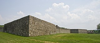
Fort Mountain State Park is a 3,712-acre (15.02 km2) Georgia state park located between Chatsworth and Ellijay on Fort Mountain. The state park was founded in 1938 and is named for an ancient 885-foot-long (270 m) rock wall located on the peak. The nomination form for the National Register of Historic Places describes the wall as "more of a marker than a fortification, separating the north peak from the southern end."

<span class="mw-page-title-main">Spring Mountain Ranch State Park</span> State park in Nevada, United States

Spring Mountain Ranch State Park is a public recreation area located within the Red Rock Canyon National Conservation Area in Nevada's Cottonwood Valley, five miles (8.0 km) northwest of Blue Diamond, Nevada. The state park preserves the historic Sandstone Ranch, which was entered into the National Register of Historic Places as a historic district in 1976.

<span class="mw-page-title-main">New Echota</span> United States historic place

New Echota was the capital of the Cherokee Nation in the Southeast United States from 1825 until their forced removal in the late 1830s. New Echota is located in present-day Gordon County, in northwest Georgia, 3.68 miles north of Calhoun. It is south of Resaca, next to present day New Town, known to the Cherokee as Ꭴꮝꮤꮎꮅ, Ustanali. The site has been preserved as a state park and a historic site. It was designated in 1973 as a National Historic Landmark District.

<span class="mw-page-title-main">Fort Frederick State Park</span> State park in Maryland, US

Fort Frederick State Park is a public recreation and historic preservation area on the Potomac River surrounding the restored Fort Frederick, a fortification active in the French and Indian War (1754–1763) and the American Revolutionary War (1775-1783). The state park lies south of the town of Big Pool, Maryland. The Chesapeake and Ohio Canal runs through the park grounds. The site was designated a National Historic Landmark in 1973.

<span class="mw-page-title-main">Chief Vann House Historic Site</span> Historic house in Georgia, United States

The Chief Vann House is the first brick residence in the Cherokee Nation, and has been called the "Showplace of the Cherokee Nation". Owned by the Cherokee Chief James Vann, the Vann House is a Georgia Historic Site on the National Register of Historic Places and one of the oldest remaining structures in the northern third of the state of Georgia. It is located in Murray County, on the outskirts of Chatsworth in northwest Georgia, which has a commanding view of the land around it and of the Cohutta Mountains, about 10 miles (16 km) to the east.

<span class="mw-page-title-main">Providence Canyon State Park</span> State park in Georgia, United States

Providence Canyon State Outdoor Recreation Area is a 1,003-acre (405.90 ha) Georgia state park located in Stewart County in southwest Georgia, United States. The park contains Providence Canyon, which is sometimes called Georgia's "Little Grand Canyon". It is considered one of the Seven Natural Wonders of Georgia. It is also home to the very rare plumleaf azalea.

<span class="mw-page-title-main">Washington State Park</span>

Washington State Park is a public recreation area covering 2,147 acres (869 ha) in Washington County in the central eastern part of the state of Missouri. It is located on Highway 21 about 14 miles (23 km) northeast of Potosi or 7 miles (11 km) southwest of DeSoto on the eastern edge of the Ozarks. The state park is noted for its Native American rock carvings and for its finely crafted stonework from the 1930s.

<span class="mw-page-title-main">Georgia State Route 2</span> State highway in Georgia

State Route 2 (SR 2) is a 165-mile-long (266 km) east-west State highway in the far North-northern part of Georgia. The highway serves southern suburbs of Chattanooga, Tennessee, as well as much of the mountains in the northern part of the state. It traverses the counties of Walker, Catoosa, Whitfield, Murray, Gilmer, Fannin, Union, Towns, and Rabun. It connects Flintstone, in the northwestern part of the state, with the South Carolina state line southeast of Clayton in the northern part and the northeastern part of the state. It also travels through Fort Oglethorpe, Ringgold, Ellijay, Blue Ridge, Blairsville, and Hiawassee. Parts of the highway in the Whitfield and Murray county area are designated as the Cohutta–Chattahoochee Scenic Byway.

<span class="mw-page-title-main">Georgia State Route 52</span> State highway in Georgia, United States

State Route 52 (SR 52) is a 124.697-mile-long (200.680 km) state highway that travels west to east through portions of Whitfield, Murray, Gilmer, Dawson, Lumpkin, Hall, Banks, and Jackson counties in the northern part of the U.S. state of Georgia. The highway extends from its western terminus at Interstate 75 (I-75) in Dalton to its eastern terminus at SR 98 in Maysville.

<span class="mw-page-title-main">Red Clay State Historic Park</span> State park in Tennessee, United States

Red Clay State Historic Park is a state park located in southern Bradley County, Tennessee, United States. The park was the site of the last capital of the Cherokee Nation in the eastern United States from 1832 to 1838 before the enforcement of the Indian Removal Act of 1830. This resulted in a forced migration of most of the Cherokee people to present-day Oklahoma known as the Cherokee removal. The site is considered sacred to the Cherokees, and includes the Blue Hole Spring, a large hydrological spring. It is also listed as an interpretive center along the Trail of Tears National Historic Trail.

<span class="mw-page-title-main">Nacoochee Mound</span> Archaeological site in Georgia, US

<span class="mw-page-title-main">Carters Lake (Blue Ridge Mountains)</span> Man-made lake in Georgia, United States

Carters Lake is a man-made reservoir located on the Coosawattee River in the Blue Ridge Mountains in Gilmer and Murray counties in the U.S. state of Georgia. It is the state's deepest lake.

<span class="mw-page-title-main">U.S. Route 76 in Georgia</span> U.S. highway in Georgia

U.S. Route 76 (US 76) is a 150.7-mile-long (242.5 km) east–west U.S. highway in the U.S. state of Georgia. It begins at the Tennessee state line, east of Lakeview, Georgia, where the roadway continues concurrent with US-41/SR-8 toward Chattanooga. It ends at the South Carolina state line, where US 76 continues toward Anderson. In Georgia, the highway travels within portions of Catoosa, Whitfield, Murray, Gilmer, Fannin, Union, Towns, and Rabun counties. It travels through North Georgia and connects Ringgold, Dalton, Chatsworth, Ellijay, Blue Ridge, Blairsville, and Clayton. Most of the highway is part of the Lookout Mountain Scenic Highway, a highway that travels through northern Georgia and through the Chattahoochee-Oconee National Forest.

<span class="mw-page-title-main">Moon-eyed people</span> Cherokee legend

The moon-eyed people are a legendary group of short, bearded white-skinned people who are said to have lived in Appalachia until the Cherokee expelled them. Stories about them, attributed to Cherokee tradition, are mentioned by early European settlers in America. In a 1797 book, Benjamin Smith Barton explains they are called "moon-eyed" because they saw poorly during the day. Some stories claim they created the area's pre-Columbian ruins, and they disappeared from the area. Barton cited as his source a conversation with Colonel Leonard Marbury, an early settler of Georgia. Marbury, a Revolutionary War officer and a Congressman in the Second Provincial Congress of Georgia (1775), acted as intermediary between Native American Indians in the state of Georgia and the United States government.

References

  1. "National Register Information System". National Register of Historic Places . National Park Service. July 9, 2010.
  2. n/a 'Chatsworth, GA, PRN' (November 20, 1969). "Forsyth County News ('Fort Mountain')". Tour Georgia: State of Adventure (PRN). Cumming, GA, USA: The Forsyth County News. p. 4. Archived from the original (Clipping) on February 4, 2021. Retrieved February 4, 2021.{{cite news}}: CS1 maint: multiple names: authors list (link)
  3. Smith, Philip E., "Aboriginal Stone Constructions in the Southern Piedmont" in the University Of Georgia Laboratory Of Archaeology Series Report No 4 1962
  4. State of Georgia (July 1, 2007). "Georgia Dept. of Natural Resources". Department of Natural Resources, Division of State Parks & Historic Sites. Georgia Department of Natural Resources. State of Georgia. Archived from the original on January 28, 2021. Retrieved February 2, 2021.
  5. State of Georgia (July 1, 2007). "Georgia DNR (Trails at Fort Mountain State Park)". Department of Natural Resources. Georgia Department of Natural Resources, Division of State Parks & Historic Sites. State of Georgia. Division of State Parks & Historic Sites. Archived from the original on November 24, 2020. Retrieved February 3, 2021.
  6. State of Georgia (July 1, 2007). "Georgia Dept. of Natural Resources". Department of Natural Resources, Division of State Parks & Historic Sites. Georgia Department of Natural Resources. State of Georgia. Archived from the original on January 28, 2021. Retrieved February 2, 2021.
  7. Allen, Bob (August 2, 2013). "Mo. youth group safe after bus wreck". Baptist News. Baptist News Global. Archived from the original on February 3, 2021. Retrieved February 3, 2021.
  8. "Global Youth Ministry on Fort Mountain". Global Youth Ministry. Full Circle Creations. February 3, 2021. Archived from the original on November 23, 2020. Retrieved February 3, 2021.
  9. State of Georgia (July 1, 2007). "Georgia Dept. of Natural Resources". Department of Natural Resources, Division of State Parks & Historic Sites. Georgia Department of Natural Resources. State of Georgia. Archived from the original on January 28, 2021. Retrieved February 2, 2021.
  10. McCain, Stacy (August 28, 1994). "Whites built mystery of Fort Mountain, but not stone wall". Rome News Tribune . Rome, Georgia. Retrieved August 31, 2016.
  11. National Park Service (ed.). "National Register of Historic Places". National Register of Historic Places. National Register Digital Asset Management System (NPGallery). NRID77001587. Archived from the original on February 3, 2021. Retrieved February 3, 2021.
  12. Little, George (June 26, 1879). "Our State: What Makes Her an Independent State". The Free Press. Cartersville, GA, USA: The Free Press. p. 1. Archived from the original (Clipping) on February 4, 2021. Retrieved February 4, 2021.
  13. "News from Georgia" Brick and Clay Record Kenfield, Chicago: 1907, Vol. 27, No.3, 99.
  14. Knight, Lucian Lamar, "Fort Mountain," A Standard History of Georgia and Georgians. Lewis Publishing, Chicago: 1917, Vol. 1, p. 14.
  15. "Forsyth County News ('Fort Mountain')". Archived from the original on February 4, 2021. Retrieved February 4, 2021.