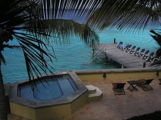
Bonaire is a Caribbean island in the Leeward Antilles, and is a special municipality of the Netherlands. Its capital is the port of Kralendijk, on the west (leeward) coast of the island. Aruba, Bonaire and Curaçao form the ABC islands, 80 km off the coast of Venezuela. Unlike much of the Caribbean region, the ABC islands lie outside Hurricane Alley. The islands have an arid climate that attracts visitors seeking warm, sunny weather all year round. Bonaire is a popular snorkeling and scuba diving destination because of its multiple shore diving sites and easy access to the island's fringing reefs.

Oranjestad is a small town of 1,038 inhabitants; it is the capital and largest town of the island of Sint Eustatius in the Caribbean Netherlands. It’s not to be confused with the far larger Oranjestad in Aruba.

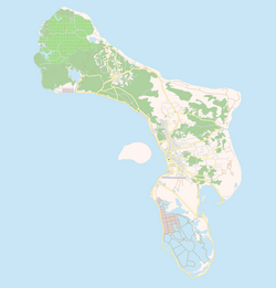
Kralendijk is the capital city and main port of the island of Bonaire in the Caribbean Netherlands. The language spoken in the town is Papiamentu, but Dutch and English are widely used. As of 2017, the town had a population of 10,620. In Papiamentu, the town is often called Playa or "beach".

Dutch Antilles Express B.V. was an airline of the Dutch country of Curaçao. It operated high-frequency scheduled services in the Dutch Caribbean to United States, Dominican Republic, Colombia, Haiti, and Suriname. Its main base was at Curaçao International Airport.

Antriol is a neighbourhood of Kralendijk on the island of Bonaire in the Netherlands Antilles. It used to be a separate village which has merged into Kralendijk.

The emblem of Curaçao is a yet to be adopted national symbol of Curaçao. The design will be based on a concept by Adresetti Monart featuring the Queen Emma Bridge, a cactus, a hummingbird and a traditional fishing boat, which was chosen through a design competition held in 2022. The emblem is set to replace the coat of arms of Curaçao, which has been in use since 24 July 1964.

The Bonaire national football team is the national football team of the Caribbean island of Bonaire, a public body of the Netherlands. It is under the control of the Bonaire Football Federation. It became a member of the CFU and an associate member of CONCACAF on 19 April 2013. after which it became a full CONCACAF member on 10 June 2014 The team can participate in the CONCACAF Gold Cup and Caribbean Cup because of their membership in the confederation and sub-confederation. However, Bonaire is not a member of FIFA and therefore can not compete in the FIFA World Cup or other FIFA events.
Mamita Fox is a Curaçao-born nurse, activist, artist and writer who lives in Bonaire. Her autobiography, written in Papiamentu, is an important addition to works written in Creole languages. A well-known radio personality on the island, Fox became a vocal opponent to health care law changes by the Netherlands and how they impacted citizens of the former Netherlands Antilles. Her activism led to a change in the way health care was administered.
Evelina Betancourt-Anthony is an Aruban-born Bonairean health administrator and politician. From 1 December 2015 she has served as the Deputy Lieutenant Governor of the island and in the absence of the Island Governor fills the duties of that office.
Island council elections were held in the Netherlands Antilles on 29 April and 6 May 1983 to elect the members of the island councils of its six island territories. The election was won by the People's Electoral Movement in Aruba, the Bonaire Democratic Party in Bonaire, the New Antilles Movement in Curaçao, the Windward Islands People's Movement in Saba, the Democratic Party Statia in Sint Eustatius, and the Democratic Party in Sint Maarten.
Island council elections were held in the Netherlands Antilles on 10 April and 22 May 1987 to elect the members of the island councils of its five island territories. The election was won by the Bonaire Patriotic Union–Bonaire Workers' Party list in Bonaire, the National People's Party in Curaçao, the Saba Democratic Labour Movement in Saba, the Democratic Party Statia in Sint Eustatius, and the Democratic Party in Sint Maarten.
Island council elections were held in the Netherlands Antilles on 12 April 1991 to elect the members of the island councils of its five island territories. The election was won by the Bonaire Patriotic Union in Bonaire, the National People's Party in Curaçao, the Windward Islands People's Movement in Saba, and the Sint Maarten Patriotic Alliance in Sint Maarten.
Island council elections were held in the Netherlands Antilles on 7 April and 12 May 1995 to elect the members of the island councils of its five island territories. The election was won by the Bonaire Democratic Party in Bonaire, the Party for the Restructured Antilles in Curaçao, the Saba Democratic Labour Movement in Saba, the Democratic Party Statia in Sint Eustatius, and the Democratic Party in Sint Maarten.

Bandariba is a district of the island of Curaçao. It is one of the three districts and encompasses the south-eastern part of the island. The name is Papiamentu and translates to "upside". The district contains the towns and villages of Santa Rosa, Spaanse Water, Montaña, Seru Grandi, and Oostpunt.
Belnem is a private community on the island of Bonaire. It is luxurious neighbourhood named after Harry Belafonte and Maurice Neme. Construction of Belnem started on 3 June 1966.

Raymond Henri Pos was a Surinamese diplomat and lawyer. He was the first Minister Plenipotentiary of Suriname from 29 December 1954 until 1 August 1963. Subsequently, he was appointed Dutch Ambassador of Cuba. Pos played a major role in the creation of the 1954 Charter for the Kingdom of the Netherlands which established the political relationship between the Netherlands and its former colonies.
Otto Rudolf Anthony Beaujon was a civil servant and politician of the Netherlands Antilles. Beaujon served as Speaker of the Estates of the Netherlands Antilles between 1966 and 1968, and Prime Minister of the Netherlands Antilles from 1 June 1971 until 15 November 1972.

Fort Nassau is a fort located in Willemstad, Curaçao. It is located on a 68 metres (223 ft) high hill overlooking the city of Willemstad and its harbour. It was constructed in 1796 as Fort Republiek. In 1807, Curaçao was captured by the British, and the fort was renamed Fort George. In 1816, Curaçao was returned to Netherlands, and the fort received its current name. It lost its military function, but was used as a control tower for the Queen Emma Bridge. Since 1959, it is in use as a restaurant.

Ernesto Otilio "Netto" Petronia was an Curaçao-born Aruban businessman and politician. He served many times as a minister with multiple portfolios, and was Prime Minister of the Netherlands Antilles from 1969 until 1971.

Kralendijk Lighthouse is an active lighthouse in the town of Kralendijk, Bonaire, in the Caribbean Netherlands. It was built in 1932 on the grounds of Fort Oranje, a 17th century fort.