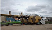
Spurn is a narrow sand tidal island located off the tip of the coast of the East Riding of Yorkshire, England that reaches into the North Sea and forms the north bank of the mouth of the Humber Estuary. It was a spit with a semi-permanent connection to the mainland, but a storm in 2013 made the road down to the end of Spurn impassable to vehicles at high tide.

The Humber is a large tidal estuary on the east coast of Northern England. It is formed at Trent Falls, Faxfleet, by the confluence of the tidal rivers Ouse and Trent. From there to the North Sea, it forms part of the boundary between the East Riding of Yorkshire on the north bank and North Lincolnshire on the south bank. Although the Humber is an estuary from the point at which it is formed, many maps show it as the River Humber.

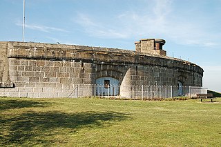
The Humber Forts are two large fortifications in the mouth of the Humber Estuary in northern England: Bull Sand Fort and Haile Sand Fort.
Coalhouse Fort is an artillery fort in the eastern English county of Essex. It was built in the 1860s to guard the lower Thames from seaborne attack. It stands at Coalhouse Point on the north bank of the river, at a location near East Tilbury which was vulnerable to raiders and invaders. It was the last in a series of fortifications dating back to the 15th century and was the direct successor to a smaller mid-19th century fort built on the same site. Constructed during a period of tension with France, its location on marshy ground caused problems from the start and led to a lengthy construction process. The fort was equipped with a variety of large-calibre artillery guns and the most modern defensive facilities of the time, including shell-proof casemates protected by granite facing and cast-iron shields. Its lengthy construction and the rapid pace of artillery development at the time meant that it was practically obsolete for its original purpose within a few years of its completion.

Beacon Hill Battery is a late-19th and 20th century coastal fortification that was built to defend the port of Harwich, Essex. It is a scheduled ancient monument.

Paull is a village and civil parish in Holderness, in the East Riding of Yorkshire, England, lying on the north bank of the Humber Estuary, east of the watercourse known as Hedon Haven.

Aldbrough is a village and civil parish in the East Riding of Yorkshire, England, about 12 miles (19 km) north-east of Hull at the junction of the B1242 and B1238 roads. It lies near to the North Sea coast within the area of Holderness.

Fort Worden Historical State Park is located in Port Townsend, Washington, on 433 acres originally known as Fort Worden, a United States Army Coast Artillery Corps base constructed to protect Puget Sound from invasion by sea. Fort Worden was named after U.S. Navy Rear Admiral John Lorimer Worden, commander of USS Monitor during the famous Battle of Hampton Roads during the American Civil War.

Fort Michie was a United States Army coastal defense site on Great Gull Island, New York. Along with Fort H. G. Wright, Fort Terry, and Camp Hero, it defended the eastern entrance to Long Island Sound as part of the Harbor Defenses of Long Island Sound, thus defending Connecticut's ports and the north shore of Long Island.

Fort Wetherill is a former coast artillery fort that occupies the southern portion of the eastern tip of Conanicut Island in Jamestown, Rhode Island. It sits atop high granite cliffs, overlooking the entrance to Narragansett Bay. Fort Dumpling from the American Revolutionary War occupied the site until it was built over by Fort Wetherill. Wetherill was deactivated and turned over to the State of Rhode Island after World War II and is now operated as Fort Wetherill State Park, a 51-acre (210,000 m2) reservation managed by the Rhode Island Department of Environmental Management.
The unsuccessful second siege of Hull by the Royalist Earl of Newcastle in 1643 was a victory for Parliament at the high point of the Royalist campaign in the First English Civil War. It led to the abandonment of the Earl of Newcastle's campaign in Lincolnshire and the re-establishment of Parliament's presence in Yorkshire.

Fort Nepean is a former defensive facility occupying part of Point Nepean, Victoria, Australia. It was part of a network of fortifications, commanded from Fort Queenscliff, protecting the narrow entrance to Port Phillip. It is now part of Point Nepean National Park and a local tourist attraction.

Culver Battery is a former coastal artillery battery on Culver Down, on the eastern side of the Isle of Wight, England. The fortification is one of several Palmerston Forts built on the island following concerns about the size and strength of the French Navy in the late 19th century. It was operational during the First and Second World Wars. The battery was closed in 1956.

Fort Duvall was a Coast Artillery fort, part of the Harbor Defenses of Boston, in Massachusetts. What was then called Hog Island in Hull, Massachusetts was acquired by the U.S. government in 1917, and the fort was constructed in the early 1920s. It had only one gun battery, Battery Long, but it mounted the largest caliber weapons in the entire harbor defense system: a pair of 16-inch guns. These were the 16-inch gun M1919, of which only seven were deployed; 16-inch weapons deployed later were supplied by the Navy.

Fort Revere is an 8-acre (3.2 ha) historic site situated on a small peninsula located in Hull, Massachusetts. It is situated on Telegraph Hill in Hull Village and contains the remains of two seacoast fortifications, one from the American Revolution and one that served 1898–1947. There are also a water tower with an observation deck, a military history museum and picnic facilities. It is operated as Fort Revere Park by the Metropolitan Park System of Greater Boston.

The fortifications of Kingston upon Hull consisted of three major constructions: the brick built Hull town walls, first established in the early 14th century, with four main gates, several posterngates, and up to thirty towers at its maximum extent; Hull Castle, on the east bank of the River Hull, protecting Hull's river harbour, constructed in the mid 16th century and consisting of two blockhouses and a castle connected by a curtain wall; and the later 17th century Citadel, an irregular triangular, bastioned, primitive star fort replacing the castle on the east river bank.

Dummy Battery, originally known as Grain Battery, is a disused fortified gun battery located about 1 kilometre (0.62 mi) south of the village of Grain, Kent at the confluence of the Rivers Thames and Medway. Completed in 1865, it supported two nearby coast artillery batteries at Grain Fort and Grain Wing Battery, a short distance to the north. The battery's arc of fire overlapped with Grain Tower just offshore and with Garrison Point Fort on the Isle of Sheppey across the other side of the Medway. It consisted of an earthwork with a concrete core supporting several gun emplacements with magazines below. It appears to have gone out of service as a battery by the time of the First World War, though it briefly took on a role in anti-aircraft defence. It was subsequently abandoned and was severely damaged by demolitions and the removal of its earthworks, leaving only the substantial remains of its concrete core standing today.

The East Riding (Fortress) Royal Engineers was a volunteer unit of Britain's Royal Engineers formed for the defence of the Humber Estuary in the East Riding of Yorkshire. As well as serving in this role it also provided field and specialist engineer units in both World Wars. Its successors continued to serve in the Territorial Army until 1991.
91st Heavy Anti-Aircraft Regiment, Royal Artillery was a part-time unit of Britain's Territorial Army (TA) formed in the West Riding of Yorkshire just before the outbreak of World War II. Its service during the war included Home Defence during the Battle of Britain and The Blitz, and a length period in Middle East Forces. Postwar it continued to serve in the TA in the air defence role until 1955.

The East Riding Royal Garrison Artillery (ERRGA) was a part-time unit of Britain's Royal Artillery based at Hull in the East Riding of Yorkshire. It provided coastal defence artillery along the Humber Estuary from 1908 to 1956, manned siege batteries on the Western Front during World War I at the Somme and Ypres and played a role in the pursuit of the German army during the Hundred Days Offensive. It served as infantry in Allied-occupied Germany after World War II. Its successor units in the Territorial Army included anti-aircraft artillery and field engineers.