Fort Randolph (West Virginia)

Last updated
Fort Randolph
Point Pleasant, West Virginia
Fort Randolph.jpg
Modern replica of Fort Randolph
Coordinates 38°50′16″N82°07′19″W / 38.83765°N 82.12202°W / 38.83765; -82.12202 Coordinates: 38°50′16″N82°07′19″W / 38.83765°N 82.12202°W / 38.83765; -82.12202
Type stockade
Site information
Controlled byWest Virginia Humanities Council
Site history
Builtoriginal construction in 1776,
rebuilt in 1785,
modern reconstruction
in 1974
In use1776–1779; 1785–1790s
Battles/wars Western theater of the American Revolutionary War
Garrison information
Past
commanders
Matthew Arbuckle, Sr.
William McKee
Garrison100 men at full strength

Fort Randolph was an American Revolutionary War fort which stood at the confluence of the Ohio and Kanawha Rivers, on the site of present day Point Pleasant, West Virginia, USA.

Contents

Built in 1776 on the site of an earlier fort from Dunmore's War, Fort Randolph is best remembered as the place where the famous Shawnee Chief Cornstalk was murdered in 1777. The fort withstood attack by American Indians in 1778 but was abandoned the next year. It was rebuilt in the 1780s after the renewal of hostilities between the United States and American Indians, but saw little action and was eventually abandoned once again. Two centuries later, a replica of the fort has been built about a mile away.

History

Background

The site where Fort Randolph was built emerged as a strategic location in the years before the American Revolution. In the Treaty of Fort Stanwix of 1768, the British Crown acquired the title to present-day West Virginia from the Iroquois. Thereafter, American colonists and land speculators began to explore the region. One of the first to do so was George Washington, a planter and politician from Virginia, who in 1770 made a long canoe trip down the Ohio River to examine the land around Point Pleasant. Many other American colonists and surveyors did the same over the next few years.[ citation needed ]

The American Indians of the Ohio Country, who hunted on the land south of the Ohio River, had not been consulted in the 1768 treaty. The eventual result was Dunmore's War in 1774, fought primarily between American militiament from Virginia and Shawnees and Mingos from the Ohio Country, led by Chief Cornstalk. The Battle of Point Pleasant, the only major battle of the war, was fought on the future site of Fort Randolph. After the battle, a small fort called Fort Blair was built near the battlefield. With the outbreak of the American Revolutionary War in 1775, however, Lord Dunmore, the Royal Governor of Virginia, ordered the abandonment of the fort, one of his last actions before being forced from office by the American revolutionaries. [1]

Revolutionary War

In 1776, the Virginia Assembly, alarmed at the defenseless state of their western border, [2] ordered a new fort built on the site. Virginia militiamen under Captain Matthew Arbuckle, Sr., built Fort Randolph in May 1776. It was named after Peyton Randolph, the first president of the Continental Congress, who had died the previous year. [3] The fort, along with Fort Pitt and Fort Henry, was intended to prevent Indian raids into western Virginia and Pennsylvania.

Gravesite of Cornstalk at Tu-Endie-Wei State Park in Point Pleasant, near where Fort Randolph stood. Cornstalk gravesite.jpg
Gravesite of Cornstalk at Tu-Endie-Wei State Park in Point Pleasant, near where Fort Randolph stood.

The forts failed to deter raids. In November 1776, Andrew Donnally and Archer Mathews, commissaries for the fort, described the difficulties of supplying the fort with food and provisions due to the constant threat of Indian attack. [4] In 1777, the Americans made preparations for an offensive expedition into the Ohio Country. In November, Cornstalk made a diplomatic visit to Fort Randolph in order to discuss the rumored expedition. Shawnees who followed Cornstalk wanted to stay out of the war, but Cornstalk warned the Americans that he would not be able to keep all of the tribe neutral. [5] Although the proposed campaign had been cancelled because of a manpower shortage, Captain Arbuckle decided to detain Cornstalk and several other Shawnees as hostages in order to ensure that the Shawnees stayed neutral. When an American militiaman was killed outside the fort by Indians on November 10, his enraged companions charged into the fort and murdered Cornstalk and the other three Shawnee prisoners. Virginia's governor Patrick Henry brought the killers to trial, but they were acquitted because no one would testify against them. [6]

On May 20, 1778, about 200 Wyandots and Mingos under Dunquat, the Wyandot "Half King", surrounded Fort Randolph and began a week-long siege. Unable to compel the surrender of the fort, the Indians then moved up the Kanawha to attack Fort Donnally, which also withstood attack. [7] Apparently because resources were needed elsewhere, Fort Randolph was abandoned by the Americans in 1779. [8] Indians burned the fort after it was abandoned. [3]

Twice rebuilt

The fort was rebuilt nearby in 1785 during the growth of violence which led to the Northwest Indian War.

A replica of the fort was built in 197374 and dedicated on 10 October 1974, the 200th anniversary of the Battle of Point Pleasant. The town of Point Pleasant had spread over where the fort had stood, and so the rebuilt fort was located at Krodel Park, about one mile from the original location. [9]

Related Research Articles

Mason County, West Virginia U.S. county in West Virginia

Mason County is a county in the U.S. state of West Virginia. As of the 2010 census, the population was 27,324. Its county seat and largest city is Point Pleasant. The county was founded in 1804 and named for George Mason, delegate to the U.S. Constitutional Convention. Before the Civil War, the county was in the State of Virginia.

Point Pleasant, West Virginia City in West Virginia, United States

Point Pleasant is a city in and the county seat of Mason County, West Virginia, United States, at the confluence of the Ohio and Kanawha Rivers. The population was 4,350 at the 2010 census. It is the principal city of the Point Pleasant, WV-OH Micropolitan Statistical Area.

Lord Dunmores War

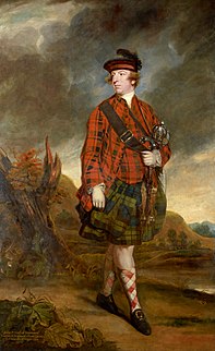
Lord Dunmore's War—or Dunmore's War—was a 1774 conflict between the Colony of Virginia and the Shawnee and Mingo American Indian nations.

Fort Henry (West Virginia) Military base in Wheeling, West Virginia, USA

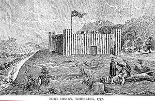
Fort Henry was a colonial fort which stood about ¼ mile from the Ohio River in what is now downtown, Wheeling, West Virginia. The fort was originally known as Fort Fincastle and was named for Viscount Fincastle, Lord Dunmore, Royal Governor of Virginia. Later it was renamed for Patrick Henry, and was at the time located in Virginia. The fort was subject to two major sieges, two notable feats and other skirmishes.

Kanawha River

The Kanawha River is a tributary of the Ohio River, approximately 97 mi (156 km) long, in the U.S. state of West Virginia. The largest inland waterway in West Virginia, its valley has been a significant industrial region of the state since early in the 19th century.

Battle of Point Pleasant

The Battle of Point Pleasant — known as the Battle of Kanawha in some older accounts — was the only major action of Dunmore's War. It was fought on October 10, 1774, primarily between Virginia militia and Native Americans from the Shawnee and Mingo peoples. Along the Ohio River near modern Point Pleasant, West Virginia, forces under the Shawnee Chief Cornstalk attacked Virginia militia under Colonel Andrew Lewis, hoping to halt Lewis's advance into the Ohio Valley. After a long and furious battle, Cornstalk retreated. After the battle, the Virginians, along with a second force led by Lord Dunmore, the Royal Governor of Virginia, marched into the Ohio Valley and compelled Cornstalk to agree to a treaty, ending the war.

Cornstalk Shawnee tribe leader in the American Revolution

Cornstalk was a prominent leader of the Shawnee nation just prior to the American Revolutionary War. His tribal name, "Hokoleskwa," translates loosely into "stalk of corn" in English.

Pickaway Plains is a wide area of rolling hills beginning about 3 miles south of Circleville, Ohio, and extending several miles to the north and south. This geological area was formed by sand and gravel deposited by melting water from the last glacier to retreat from the region during the Ice Age. During the time of inhabitation by the Shawnee, the Pickaway Plains were covered by prairie vegetation, mainly grasses.

William Crawford (soldier)

William Crawford was an American soldier and surveyor who worked as a western land agent for George Washington. Crawford fought in the French and Indian War and the American Revolutionary War. He was tortured and burned at the stake by American Indians in retaliation for the Gnadenhutten massacre, a notorious slaughter of Indians by militia near the end of the American Revolution.

Western theater of the American Revolutionary War Area of conflict west of the Appalachian Mountains

The Western theater of the American Revolutionary War (1775–1783) was the area of conflict west of the Appalachian Mountains, the region which became the Northwest Territory of the United States as well as the states of Kentucky, Tennessee, and Missouri. The western war was fought primarily between American Indians with their British allies in Detroit, and American settlers south and east of the Ohio River.

Andrew Lewis was an Irish-born American pioneer, surveyor, and soldier of Colonial Virginia. A colonel of militia during the French and Indian War, and brigadier general in the American Revolutionary War, Lewis is most famous for his 1774 victory in the Battle of Point Pleasant in Dunmore's War. He also helped found Liberty Hall, when it was made into a college in 1776.

Tu-Endie-Wei State Park

Tu-Endie-Wei State Park is located at the confluence of the Kanawha River and the Ohio River in downtown Point Pleasant, West Virginia. The park commemorates the Battle of Point Pleasant, fought between the settler militia of Virginia and the forces of Shawnee Chief Cornstalk on October 10, 1774. The militia victory by the settlers weakened the alliance between native forces and the British and freed up settlers from western Virginia to cross the Allegheny Mountains and join in the American Revolutionary War.

Daniel Greathouse (c.1752—1775) was a settler in colonial Virginia. His role in the Yellow Creek massacre in 1774 was instrumental in starting Lord Dunmore's War.

Michael Cresap

Captain Michael Cresap was a noted frontiersman born in Maryland.

Colonel John Stuart was a Revolutionary War commander and pioneering western Virginia settler. A veteran of the Battle of Point Pleasant (1774), he surveyed and settled the Greenbrier Valley and is known locally as the "Father of Greenbrier County". Owing to his Memoir of Indian Wars and Other Occurrences, written in 1799, he has been called "the most important chronicler of pioneer history in southern West Virginia".

Captain Mathew Arbuckle Sr., was a pioneering hunter and trapper of western Virginia and the Ohio territory. He is considered likely to have been the first white person to travel through Virginia all the way to the Ohio River, other than as a prisoner of the Indians. This trapping and trading trip may have occurred around 1764.

William Ward was the founder of Urbana, Ohio, and one of the original settlers in Kentucky's Mason County and Ohio's Mad River Valley.

Lewis District, Mason County, West Virginia Magisterial district in West Virginia, United States

Lewis Magisterial District is one of ten magisterial districts in Mason County, West Virginia. The district was originally established as a civil township in 1863, and converted into a magisterial district in 1872. In 2010, Robinson District was home to 6,082 people.

David Glenn (pioneer)

David Glenn was of Irish descent and was born in 1753, likely in Pennsylvania but possibly in Virginia. He was one of the early settlers of Kentucky having accompanied James Harrod in founding Harrodstown in 1774, along with his older brother, Thomas. Today, Harrodsburg is considered the oldest permanent white settlement in Kentucky, being it was settled almost a full year before Boonesborough.

Thomas Glenn (pioneer)

Thomas Glenn was among the first pioneers to venture into the Western Virginia and Kentucky territories. He was born in 1750 in present-day Pennsylvania, married before 1770 and settled in present-day Wheeling, West Virginia by 1774, but possibly earlier. He was part of an advanced detachment of John Floyd's survey expedition before joining James Harrod's party in founding Harrodstown, the earliest permanent white settlement west of the Appalachians, along with his younger brother David Glenn. Together they explored a large portion of Kentucky in the 1770s making several improvements from Frankfort down to Russell Springs.

References

  1. Reuben G. Thwaites and Louise P. Kellogg, eds., The Revolution on the Upper Ohio, 1775–1777 (Orig. pub. 1908, reprint New York: Kennikat, 1970), 13.
  2. Randolph C. Downes, Council Fires on the Upper Ohio: A Narrative of Indian Affairs in the Upper Ohio Valley until 1795 (University of Pittsburgh Press, 1940; reprinted 1989, ISBN   0-8229-5201-7), 188.
  3. 1 2 History of Fort Randolph
  4. Thwaites, Reuben (1908). The Revolution on the Upper Ohio, 1775-1777. Madison, Wisconsin: Wisconsin Historical Society. p. 209. ISBN   1556136390 . Retrieved July 25, 2020.
  5. Downes, Council Fires, 205–06.
  6. Downes, Council Fires, 207.
  7. William Nester, The Frontier War for American Independence (Mechanicsburg, PA: Stackpole, 2004; ISBN   0-8117-0077-1), 195.
  8. Otis Rice, West Virginia: A History, 2nd ed. (University Press of Kentucky, 1993), 43.
  9. Fort Randolph restoration, from Fort Randolph website