
Lake County is one of the 36 counties in the U.S. state of Oregon. As of the 2020 census, the population was 8,160. Its county seat is Lakeview. The county is named after the many lakes found within its boundaries, including Lake Abert, Summer Lake, Hart Lake, and Goose Lake.

Lakeview is a town in Lake County, Oregon, United States. The population was 2,418 at the 2020 census. It is the county seat of Lake County. The city bills itself as the "Tallest Town in Oregon" because of its elevation, 4,757 feet (1,450 m) above sea level. Lakeview is situated in the Goose Lake Valley at the foot of the Warner Mountains and at the edge of Oregon's high desert country. Its economy is based on agriculture, lumber production, and government activities. In addition, tourism is an increasingly important part of the city's economy. Oregon's Outback Scenic Byway passes through Lakeview.

The Dalles, formally the City of The Dalles and also called Dalles City, is an inland port and the largest city in Wasco County, Oregon, United States. The population was 16,010 at the 2020 census, and it is the largest city in Oregon along the Columbia River outside the Portland Metropolitan Area. The Dalles is 75 miles east of Portland, within the Columbia River Gorge National Scenic Area.

Fort Rock is a tuff ring located on an ice age lake bed in north Lake County, Oregon, United States. The ring is about 4,460 feet (1,360 m) in diameter and stands about 200 feet (60 m) high above the surrounding plain. Its name is derived from the tall, straight sides that resemble the palisades of a fort. The region of Fort Rock–Christmas Lake Valley basin contains about 40 such tuff rings and maars and is located in the Brothers Fault Zone of central Oregon's Great Basin. William Sullivan, an early settler in the area, named Fort Rock in 1873 while searching for lost cattle.

Christmas Valley is an unincorporated community in Lake County, Oregon, United States. The community was named after nearby Christmas Lake, usually dry, east of the present town and the site of the former Lake post office, which ran from 1906 until 1943. Real estate development around a planned community by M. Penn Phillips, called Christmas Valley, started after World War II. The Christmas Valley post office was established in 1963 as a rural station of Silver Lake.
Silver Lake is an unincorporated community and census-designated place in western Lake County, Oregon, United States, along Oregon Route 31. As of the 2010 census, it had a population of 149. Facilities include a gas station and a small store, a post office, and a public school, North Lake School, serving grades K-12.
Breitenbush is an unincorporated community in Marion County, Oregon, United States, located approximately 10 miles NE of Detroit, Oregon, and 10 miles NW of Mt. Jefferson. The community is situated on private land, encompassed entirely by the Willamette National Forest, and is notable for having several hot springs, both nearby and on the property. It is said to have been originally homesteaded in 1888, and its hot springs have seen varied degrees of development and use since that time. In its heyday as a resort, the community was served by a post office, which operated between 1928 and 1953.

Plush is an unincorporated rural community and census-designated place in the Warner Valley of Lake County, in the U.S. state of Oregon. As of the 2010 census it had a population of 57. The community is in an arid, sparsely populated part of the state 39 miles (63 km) by road northeast of Lakeview. The valley surrounding Plush contains many marshes and shallow lakes, most of them intermittent.
Rockport is a ghost town in a narrow part of Weber Valley at the mouth of Three Mile Canyon in Summit County, Utah, United States. Located 4 miles (6.4 km) south of Wanship, it was inhabited for nearly a century before the creation of Rockport Reservoir, which covered almost the whole townsite.
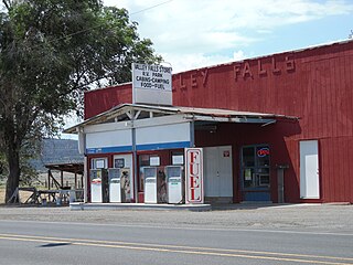
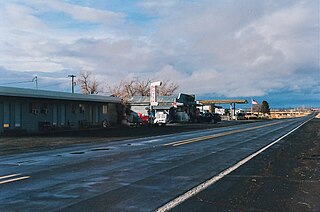
Valley Falls is a small unincorporated community in Lake County, Oregon, United States. The settled area is located at the junction of U.S. Route 395 and Oregon Route 31. The community is named for a small falls on the Chewaucan River just north of the occupied site. East of Valley Falls, the cliff face of Abert Rim overlooks the community.

Camp Scheideck, California is an unincorporated community in Ventura County in Southern California within the Cuyama Valley about 37 miles (60 km) due north of Ojai and 30 miles (48 km) from Frazier Park in Kern County.
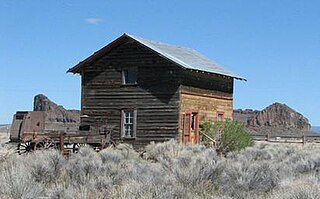
The Fort Rock Valley Historical Homestead Museum is located in Fort Rock, Oregon, United States. Opened in 1988, it is a collection of original homestead-era buildings including a church, school, houses, homestead cabins, and several other buildings assembled in a village setting. The structures were moved to the museum site from various locations around the Fort Rock Valley, named for volcanic landmark Fort Rock. Most of the buildings contain historic items used by local homesteaders including furniture, dishes, household products, and tools. The museum is open for self-guided tours from Memorial Day weekend through Labor Day weekend.
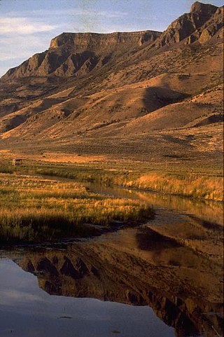
The Warner Valley is a valley in south-central Oregon in the United States. It is a remote valley at the northwestern corner of North America's Basin and Range Province. The valley is home to a chain of lakes and wetlands known as the Warner Lakes. Native Americans were present in the Warner Valley for thousands of years before European explorers arrived in the 19th century. It is the site of Fort Warner, built by the United States Army in 1867. The fort was used as a supply depot and administrative headquarters during a protracted Army campaign against Northern Paiute bands in eastern Oregon and northern California. Today, livestock ranching is the main commercial activity in the valley. The Warner Valley offers a number of recreational opportunities including hunting, fishing, bird watching, and wildlife viewing.

The Goose Lake Valley is located in south-central Oregon and northeastern California in the United States. It is a high valley at the northwestern corner of North America's Great Basin. Much of the valley floor is covered by Goose Lake, a large endorheic lake that straddles the Oregon–California border. Native Americans inhabited the Goose Lake Valley for thousands of years before explorers arrived in the 19th century. The pioneer wagon route known as the Applegate Trail crossed the Goose Lake Valley on its way to southern Oregon. At the south end of Goose Lake, the Lassen Cutoff separated from the Applegate Trail and headed south toward the Sacramento Valley. Today, Lakeview, Oregon, is the largest settlement in the valley. Livestock ranching and lumber mills are the valley's main commercial activity. The Goose Lake Valley offers a number of recreational opportunities including hang-gliding, hunting, fishing, and birdwatching.

The Catlow Valley is a basin in Harney County, Oregon, United States. It is a remote valley at the northwestern corner of North America's Basin and Range Province. The valley is named after a pioneer rancher, John Catlow. The area was used by Native Americans for thousands of years before European explorers arrived in the 19th century. Today, cattle ranching is the main commercial activity in the valley. The public land in the Catlow Valley is administered by the Bureau of Land Management. This public land offers a number of recreational opportunities including hiking, hunting, fishing, bird watching, and wildlife viewing.

Fossil Lake is a dry lakebed in the remote high desert country of northern Lake County in the U.S. state of Oregon. During the Pleistocene epoch, Fossil Lake and the surrounding basin were covered by an ancient lake. Numerous animals used the lake's resources. Over time, the remains of many of these animals became fossilized in the lake sediments. As a result, Fossil Lake has been an important site for fossil collection and scientific study for well over a century. Over the years, paleontologists have found the fossil remains of numerous mammals as well as bird and fish species there. Some of these fossils are 2 million years old.

Mark W. Bullard, also known as M. W. Bullard, was an American pioneer who established homesteads in Oregon and Washington state. As a young man, he traveled from his family home in Vermont to California and then on to Oregon and Washington. He eventually settled in what is now Pacific County, Washington. He served in the Washington territorial militia during a regional Indian war in the mid-1850s. After the war, he moved to the Goose Lake Valley in south central Oregon. While there, he donated property to establish a new town that became Lakeview, Oregon, the county seat of Lake County. He later returned to his farm in Pacific County, Washington.

Stauffer was an unincorporated community located in Lake County, Oregon, United States. The first homesteaders arrived in the area around 1910. By 1918, the local population was declining rapidly due to the harsh environment. Today, Stauffer is a ghost town with no population and no surviving structures. The site is located approximately 12 miles (19 km) south of U.S. Route 20 between Bend and Burns, Oregon. The nearest inhabited place is Hampton, Oregon, 21 miles (34 km) northwest of the Stauffer site.

Fremont was an unincorporated community located in Lake County, Oregon, United States. The first homesteaders arrived in the area around Fremont in 1905. The population grew quickly, and the Fremont post office was opened in 1908. By 1915, the local population was declining rapidly due to a severe drought that dried up surface water and lowered the water table in the area around Fremont. Today, Fremont is a ghost town with no population and no surviving structures. The site is located approximately 5 miles (8.0 km) west of Fort Rock state park. The nearest inhabited place is the small unincorporated community of Fort Rock, Oregon, which is 6 miles (9.7 km) southeast of the Fremont townsite.

Fleetwood was an unincorporated community located in Lake County, Oregon, United States. The first homesteaders arrived in the area around Fleetwood in 1905. The Fleetwood post office was opened in 1913. By 1920, the local population was declining due to a severe drought that dried up surface water and lowered the water table in the area around Fleetwood. Today, Fleetwood is a ghost town with no population and no surviving structures at the townsite. The site is located approximately 10 miles (16 km) east of Fort Rock state park. The nearest inhabited place is the small unincorporated community of Fort Rock, Oregon, which is 9 miles (14 km) west of the Fleetwood townsite.


