Mercer County is a county in the U.S. state of North Dakota. As of the 2020 census, the population was 8,350. Its county seat is Stanton.

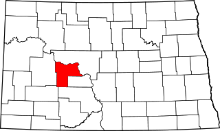
McLean County is a county in the U.S. state of North Dakota. As of the 2020 census, the population was 9,771. Its county seat is Washburn.
The Marias Massacre was a massacre of Piegan Blackfeet Native peoples which was committed by the United States Army as part of the Indian Wars. The massacre occurred on January 23, 1870, in Montana Territory. Approximately 200 Native people were killed, most of whom were women, children, and older men.
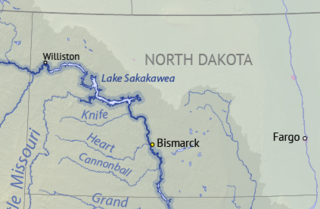
Lake Sakakawea is a large reservoir in the north central United States, impounded in 1953 by Garrison Dam, a U.S. Army Corps of Engineers dam located in the Missouri River basin in central North Dakota. Named for the Shoshone-Hidatsa woman Sakakawea, it is the largest man-made lake located entirely within North Dakota, the second largest in the United States by area after Lake Oahe, and the third largest in the United States by volume, after Lake Mead and Lake Powell.

Garrison Dam is an earth-fill embankment dam on the Missouri River in central North Dakota, U.S. Constructed by the U.S. Army Corps of Engineers from 1947 to 1953, at over 2 miles (3.2 km) in length, the dam is the fifth-largest earthen dam in the world. The reservoir impounded by the dam is Lake Sakakawea, which extends to Williston and the confluence with the Yellowstone River, near the Montana border.
The Mandan, Hidatsa, and Arikara Nation, also known as the Three Affiliated Tribes, is a Native American Nation resulting from the alliance of the Mandan, Hidatsa, and Arikara peoples, whose native lands ranged across the Missouri River basin extending from present day North Dakota through western Montana and Wyoming.
The Fort Stevenson State Park Arboretum is an arboretum located near the campground at Fort Stevenson State Park [438 acres (177 ha)] on the north shore of Lake Sakakawea approximately 3 miles south of Garrison, North Dakota.

The Fort Berthold Indian Reservation is a U.S. Indian reservation in western North Dakota that is home for the federally recognized Mandan, Hidatsa, and Arikara Nation, also known as the Three Affiliated Tribes. The reservation includes lands on both sides of the Missouri River. The tribal headquarters is in New Town, the 18th largest city in North Dakota.
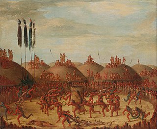
Like-a-Fishhook Village was a Native American settlement next to Fort Berthold in North Dakota, United States, established by dissident bands of the Three Affiliated Tribes, the Mandan, Arikara and Hidatsa. Formed in 1845, it was also eventually inhabited by non-Indian traders, and became important in the trade between Natives and non-Natives in the region.

Philippe Régis Denis de Keredern de Trobriand was a French aristocrat, lawyer, poet, and novelist who, on a dare, emigrated in his 20s to the United States, settling first in New York City. During the American Civil War, he became naturalized, was commissioned and served in the Union Army, reaching the rank of Major general.

The North Dakota Lewis and Clark Interpretive Center, operated by the North Dakota Parks and Recreation Department, interprets the history of the Lewis and Clark Expedition. It focuses on the winter of 1804–1805, which they spent at Fort Mandan, a post they built near a Mandan village. The center was opened in 1997 and overlooks the Missouri River on the outskirts of Washburn, North Dakota, the center opened in 1997. It is located about two miles from the reconstructed Fort Mandan.

Fort Fetterman was constructed in 1867 by the United States Army on the Great Plains frontier in Dakota Territory, approximately 11 miles northwest of present-day Douglas, Wyoming. Located high on the bluffs south of the North Platte River, it served as a major base for the start of several United States military expeditions against warring Native American tribes. The fort is listed on the National Register of Historic Places.

Fort Abercrombie, in North Dakota, was a United States Army fort established by authority of an Act of Congress, March 3, 1857. The act allocated twenty-five square miles of land on the Red River of the North in Dakota Territory to be used for a military outpost, but the exact location was left to the discretion of Lieutenant Colonel John J. Abercrombie. The fort was constructed in the year 1858. It was the first permanent military installation in what became North Dakota, and is thus known as "The Gateway to the Dakotas". Abercrombie selected a site right on the river. Spring flooding was a problem and the fort was abandoned. However, in 1860 the Army returned, moving the fort to higher ground.

Fort Craig was a U.S. Army fort located along El Camino Real de Tierra Adentro, near Elephant Butte Lake State Park and the Rio Grande in Socorro County, New Mexico.

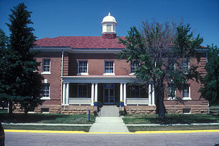
Fort Totten State Historic Site is a historic fort that sits on the shores of Devils Lake near Fort Totten, North Dakota. During its 13 years of operation as a fort, Fort Totten was used during the American Indian wars to enforce the peace among local Native American tribes and to protect transportation routes. After its closing in 1890, it operated until 1959 as a Native American boarding school, called the Fort Totten Indian Industrial School. It was added to the National Register of Historic Places in 1971; in its nomination form, the State Historical Society of North Dakota called it "one of the best preserved military posts... in the Trans-Mississippi West for the Indian Wars period".
Fort Berthold was the name of two successive forts on the upper Missouri River in present-day central-northwest North Dakota. Both were initially established as fur trading posts. The second was adapted as a post for the U.S. Army. After the Army left the area, having subdued Native Americans, the fort was used by the US as the Indian Agency for the regional Arikara, Hidatsa, and Mandan Affiliated Tribes and their reservation.
Fort Shaw was a United States Army fort located on the Sun River 24 miles west of Great Falls, Montana, in the United States. It was founded on June 30, 1867, and abandoned by the Army in July 1891. It later served as a school for Native American children from 1892 to 1910. Portions of the fort survive today as a small museum. The fort lent its name to the community of Fort Shaw, Montana, which grew up around it.
Fort Meade, originally known as Camp Sturgis and later Camp Ruhlen, is a former United States Army post located just east of Sturgis, South Dakota, United States. The fort was active from 1878 to 1944; the cantonment is currently home to a Veterans Health Administration hospital and South Dakota Army National Guard training facilities. Much of the former reservation is now managed by the Bureau of Land Management as the Fort Meade Recreation Area. It is also home of Fort Meade National Cemetery. Fort Meade was established in 1878 to protect illegal white settlements on the Great Sioux Reservation in the northern Black Hills, especially the nearby gold mining area around Deadwood. Several stage and freighting routes passed through Fort Meade en route to Deadwood.

Fort Stevenson State Park is a public recreation area located on a peninsula on Lake Sakakawea four miles (6.4 km) south of the community of Garrison in McLean County, North Dakota. The state park's 586 acres (237 ha) include a partial reconstruction of Fort Stevenson, the 19th-century Missouri River fort from which the park takes its name. The site of the original fort lies about two miles southwest, below the waters of Lake Sakakawea.
Lewis and Clark State Park is a public recreation area occupying 525 acres (212 ha) on the north shore of the upper reaches of Lake Sakakawea 18 miles (29 km) east of Williston in Williams County, North Dakota. The state park offers fishing, boating, camping, and picnicking.
