
Haarlemmermeer is a municipality in the west of the Netherlands, in the province of North Holland. Haarlemmermeer is a polder, consisting of land reclaimed from water. The name Haarlemmermeer means Haarlem's lake, referring to the body of water from which the region was reclaimed in the 19th century.

IJmuiden is a small port city in the Dutch province of North Holland. It is the main town in the municipality of Velsen which lies mainly to the south-east. Including its large sea locks, it straddles the mouth of the North Sea Canal to Amsterdam. To the south it abuts a large reserve of plant-covered dunes to the south, the Zuid-Kennemerland National Park. The city is on the south bank; the north bank is otherwise a steel plant and Velsen-Noord.

Hoofddorp is the main town of the Haarlemmermeer municipality in the province of North Holland in the Netherlands. In 2009, the population was just over 73,000. The town was founded in 1853, immediately after the Haarlemmermeer had been drained. Hoofddorp is located 52° 18′ 21.96″ N and 4° 41′ 26.52″ E.

The Spaarne is a river in North Holland, Netherlands. This partially canalized river connects the Ringvaart to a side branch of the North Sea Canal. It runs through Haarlem, Heemstede, and Spaarndam.

The UNESCO World Heritage Site known as the Defence Line of Amsterdam is a 135-kilometre (84 mi) ring of fortifications around Amsterdam. It has 42 forts that are 10–15 kilometres (6.2–9.3 mi) from the centre and lowlands, which can easily be flooded in time of war. The flooding was designed to give a depth of about 30 centimetres (12 in), too little for boats to cross. Any buildings within 1 kilometre (0.62 mi) of the line had to be made of wood so that they could be burnt and the obstruction removed.

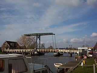
The Ringvaart is a canal in the province of North Holland, the Netherlands. The Ringvaart is a true circular canal surrounding the Haarlemmermeer polder and forms the boundary of the Haarlemmermeer municipality. Ringvaart is also the name of the dike bordering the canal.

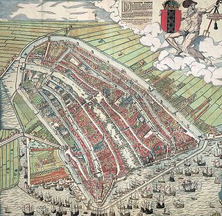
The Damrak is an avenue and partially filled in canal at the centre of Amsterdam, running between Amsterdam Centraal in the north and Dam Square in the south. It is the main street where people arriving at the station enter the centre of Amsterdam. Also it is one of the two GVB tram routes from the station into the centre, with lines 4, 9, 16, and 25 running down it. It is also on the route of the North/South Line being constructed between the existing metro station at Centraal Station and the new Rokin station.
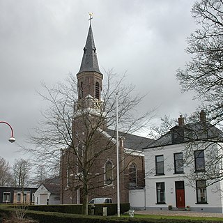
Vijfhuizen is a town in the Dutch province of North Holland. It is a part of the municipality of Haarlemmermeer, and lies about 4 km southeast of Haarlem.

Badhoevedorp is a town in the Dutch province of North Holland. It is a part of the municipality of Haarlemmermeer, and lies next to the Ringvaart around Haarlemmermeer at the side of the polder bordering Amsterdam / Amstelveen.
Kudelstaart is a town in the Dutch province of North Holland. It is a part of the municipality of Aalsmeer, and lies about 10 km southeast of Hoofddorp.

The Singel is one of the canals of Amsterdam. The Singel encircled Amsterdam in the Middle Ages, serving as a moat around the city until 1585, when Amsterdam expanded beyond the Singel. The canal runs from the IJ bay, near the Central Station, to the Muntplein square, where it meets the Amstel river. It is now the inner-most canal in Amsterdam's semicircular ring of canals.

The Museum De Cruquius occupies the old Cruquius steam pumping station in Cruquius, the Netherlands. It derives its name from Nicolaas Kruik (1678–1754), a Dutch land-surveyor and one of many promoters of a plan to pump the Haarlemmermeer dry. Like many well-educated men of his time, he latinized his name to Nicolaus Samuel Cruquius. During his lifetime the issue of the Haarlem Lake and how to pump it dry was international news, as the following excerpt from the Virginia Gazette on 31 May 1751 illustrates:
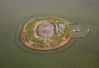
Pampus is an artificial island and late 19th-century sea fort located in the IJmeer near Amsterdam. Pampus now belongs to the municipality of Gooise Meren and is open to visitors.

Gracht is a Dutch word for a canal within a city. Grachten often have a round shape and form a circle around the city cores in the Netherlands, Belgium and northern Germany. Outside the Netherlands, the word grachten mostly refers to the city canals of Amsterdam, for which it is well known.

Schinkelbuurt is a little neighborhood of Amsterdam, Netherlands. It is located directly south of Amsterdam's city centre and it is part of the borough Amsterdam-Zuid, in the part of the city known as the Old South.

Iepenrode, or Ipenrode, is the name of a villa in Heemstede, the Netherlands, between the Leidsevaart and Herenweg, located north of Huis te Manpad and south of Berkenrode. It was once the summer home of various mayors (burgemeesters) of Haarlem and is currently privately owned.
The walls of Amsterdam were built in the Middle Ages to protect the city against attack. The Medieval walls were replaced with a series of bastions in the 17th century. In the 19th century, the walls were torn down and replaced with the Defence Line of Amsterdam, a fortification line which encircled Amsterdam at a distance from the city.
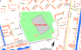
Matilo or Matilone was once a Roman fort (castellum) in modern-day Leiden. Positioned on the southern banks of the Oude Rijn, it served to protect the Roman borders in the province of Germania inferior. On the Peutinger map, it lies between the encampments of Albaniana and Praetorium Agrippinae (Valkenburg). The seventh-century Ravenna Cosmography gives its name as Matellionem.

Mouse Fort is a Dutch fort in Muiden. The fort is part of the Stelling van Amsterdam, the UNESCO World Heritage site that consists of a set of forts around the city of Amsterdam.

The Fort along Den Ham is a fort that is part of the UNESCO World Heritage site of the Stelling van Amsterdam. It's located along the railroad from Uitgeest to Krommenie. The earthen walls date from 1896, the fort itself was finished in 1903.

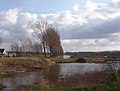 View of the geniedijk, looking southwest from fort Vijfhuizen
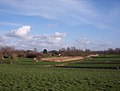 View of bunkers, representing fore position of fort Vijfhuizen
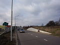 View of the road crossing the bunkers of fort Cruquius, the secondmost fore position of fort Vijfhuizen (seen from below the dike looking up towards the ringvaart. The trees are on the Heemstede side of the canal).
 Old aerial photo of the fort and surroundings along the ringvaart canal


