
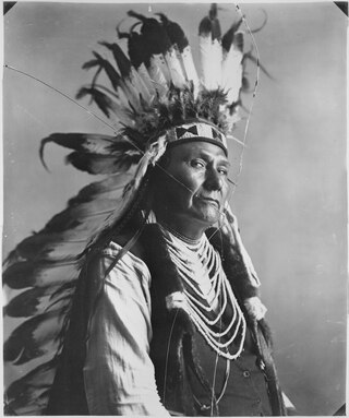
Hin-mah-too-yah-lat-kekt, popularly known as Chief Joseph, Young Joseph, or Joseph the Younger, was a leader of the wal-lam-wat-kain (Wallowa) band of Nez Perce, a Native American tribe of the interior Pacific Northwest region of the United States, in the latter half of the 19th century. He succeeded his father tuekakas in the early 1870s.

The Nez Perce War was an armed conflict in 1877 in the Western United States that pitted several bands of the Nez Perce tribe of Native Americans and their allies, a small band of the Palouse tribe led by Red Echo (Hahtalekin) and Bald Head, against the United States Army. Fought between June and October, the conflict stemmed from the refusal of several bands of the Nez Perce, dubbed "non-treaty Indians," to give up their ancestral lands in the Pacific Northwest and move to an Indian reservation in Idaho Territory. This forced removal was in violation of the 1855 Treaty of Walla Walla, which granted the tribe 7.5 million acres of their ancestral lands and the right to hunt and fish on lands ceded to the U.S. government.
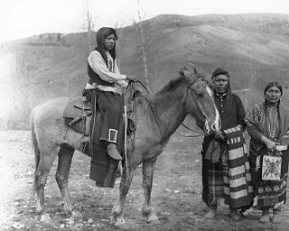
The Palouse are a Sahaptin tribe recognized in the Treaty of 1855 with the United States along with the Yakama. It was negotiated at the 1855 Walla Walla Council. A variant spelling is Palus. Today they are enrolled in the federally recognized Confederated Tribes and Bands of the Yakama Nation and some are also represented by the Colville Confederated Tribes, the Confederated Tribes of the Umatilla Indian Reservation and Nez Perce Tribe.

The Battle of Bear Paw was the final engagement of the Nez Perce War of 1877. Following a 1,200-mile (1,900 km) running fight from north central Idaho Territory over the previous four months, the U.S. Army managed to corner most of the Nez Perce led by Chief Joseph in early October 1877 in northern Montana Territory, just 42 miles (68 km) south of the border with Canada, where the Nez Perce intended to seek refuge from persecution by the U.S. government.

The Battle of Four Lakes was a battle during the Coeur d'Alene War of 1858 in the Washington Territory in the United States. The Coeur d'Alene War was part of the Yakima War, which began in 1855. The battle was fought near present-day Four Lakes, Washington, between elements of the United States Army and a coalition of Native American tribes consisting of Schitsu'umsh, Palus, Spokan, and Yakama warriors.
The First Regiment Oregon volunteer Cavalry was a volunteer regiment in United States service Union army that was formed in response to the American Civil War. With men recruited in Oregon and some recruited in surrounding states, the regiment primarily served to protect the state of Oregon and surrounding territories during the American Civil War.
The Coeur d'Alene War of 1858, also known as the Spokane-Coeur d'Alene-Pend d'oreille-Paloos War, was the second phase of the Yakima War, involving a series of encounters between the allied Native American tribes of the Skitswish, Kalispell, Spokane, Palouse and Northern Paiute against United States Army forces in Washington and Idaho.
Edward Hunter was a career American Army officer, who graduated from the West Point on June 23, 1865. He served in California, Georgia, Idaho, Minnesota, Nevada, New York, Puerto Rico, Virginia, Washington and Washington, D.C.
Fort Missoula was established by the United States Army in 1877 on land that is now part of the city of Missoula, Montana, to protect settlers in Western Montana from possible threats from the Native American Indians, such as the Nez Perce.
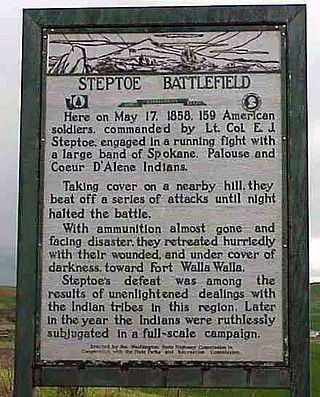
The Battle of Pine Creek, also known as the Battle of Tohotonimme and the Steptoe Disaster, was a conflict between United States Army forces under Brevet Lieutenant Colonel Edward Steptoe and members of the Coeur d'Alene, Palouse and Spokane Native American tribes. It took place on May 17, 1858, near what is present-day Rosalia, Washington. The Native Americans were victorious.

The 1st Regiment of Washington Territory Volunteer Infantry was a unit of infantry raised by the Washington Territory for service in the Union Army during the American Civil War.
Fort Lapwai (1862–1884), was a federal fort in present-day Lapwai in north central Idaho, United States. On the Nez Perce Indian Reservation in Nez Perce County, it was originally called Camp Lapwai until 1863. East of Lewiston, it was located on the west bank of Lapwai Creek, three miles (5 km) above where it joins the Clearwater River at the state's first settlement, Lapwai Mission Station, built in 1836 by Henry Spalding. It is part of the multi-site Nez Perce National Historical Park. The word "Lapwai" means place of the butterflies, as the area had thousands in early summer in earlier years.
James Jackson was an American officer in the U.S. Army during the mid- to late-19th century. He was a captain with the 12th Iowa Volunteer Infantry Regiment during the American Civil War and with the 1st U.S. Cavalry in the Indian Wars. While fighting the Nez Percé at Battle of Camas Meadows in 1877, he risked his life to recover the body of another soldier, preventing its mutilation by the enemy. For this act, he received the Medal of Honor nearly 20 years later.
The Battle of Spokane Plains was a battle during the Coeur d'Alene War of 1858 in the Washington Territory in the United States. The Coeur d'Alene War was part of the Yakima War, which began in 1855. The battle was fought west of Fort George Wright near Spokane, Washington, between elements of the United States Army and a coalition of Native American tribes consisting of Kalispel, Palus, Schitsu'umsh, Spokan, and Yakama warriors.

At the outbreak of the American Civil War, Oregon also raised the 1st Oregon Cavalry that was activated in 1862 and served until June 1865. During the Civil War, emigrants to the newfound gold fields in Idaho and Oregon continued to clash with the Paiute, Shoshone and Bannock tribes of Oregon, Idaho and Nevada until relations degenerated into the bloody 1864 - 1868 Snake War. The 1st Oregon Volunteer Infantry Regiment was formed in 1864 and its last company was mustered out of service in July 1867. Both units were used to guard travel routes and Indian reservations, escort emigrant wagon trains, and protect settlers from Indian raiders. Several infantry detachments also accompanied survey parties and built roads in central and southern Oregon.
Michael M. McCarthy was a British North America-born US Army soldier who received the Medal of Honor for his actions during the Indian Wars. He was born in St. John's, Newfoundland Colony, and moved with his family to Massachusetts in 1852.
The Battle of Cottonwood was a series of engagements July 3–5, 1877, in the Nez Perce War between the Native American Nez Perce people, and U.S. Army soldiers and civilian volunteers. Near Cottonwood, Idaho Territory, the Nez Perce, led by Chief Joseph, brushed aside the soldiers and continued their 1,170 miles (1,880 km) fighting retreat to cross the Rocky Mountains in an attempt to reach safety in Canada.

Fort Colville was a U.S. Army post in the Washington Territory located three miles (5 km) north of current Colville, Washington. During its existence from 1859 to 1882, it was called "Harney's Depot" and "Colville Depot" during the first two years, and finally "Fort Colville". Brigadier General William S. Harney, commander of the Department of Oregon, opened up the district north of the Snake River to settlers in 1858 and ordered Brevet Major Pinkney Lugenbeel, 9th Infantry Regiment to establish a military post to restrain the Indians lately hostile to the U.S. Army's Northwest Division and to protect miners who flooded into the area after first reports of gold in the area appeared in Western Washington newspapers in July 1855.
The Fort Walla Walla–Fort Colville Military Road was built in June 1859 to connect the Walla Walla area with its fairly easy access to the Columbia River to the mountainous area of the Huckleberry and Selkirk Mountains of current Northeast Washington and the Inland Northwest. Brigadier General William S. Harney, commander of the Department of Oregon, opened up the district north of the Snake River to settlers in 1858 and ordered Brevet Major Pinkney Lugenbeel, 9th Infantry Regiment to establish a U.S. Army post to restrain the Indians perceived as hostile to the U.S. Army's Northwest Division and to protect miners who traveled to the area after first reports of gold in the area appeared in Western Washington newspapers in July 1855.
The history of Walla Walla, Washington begins with the settling of Oregon Country, Fort Nez Percés, the Whitman Mission and Walla Walla County, Washington.


