
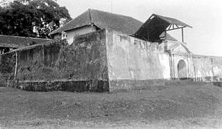
Fort Willem I, known in Indonesian/Javanese as Benteng Pendem Ambarawa (Ambarawa's Sunken Fort), is a 19th-century Dutch fortress in Ambarawa, Central Java, Indonesia. [1]
Contents
Fort Willem I, known in Indonesian/Javanese as Benteng Pendem Ambarawa (Ambarawa's Sunken Fort), is a 19th-century Dutch fortress in Ambarawa, Central Java, Indonesia. [1]
During the Diponegoro War (1827-1830), Colonel Hoorn, Commander of the 2nd Division, assigned to the crossroads at Bawen, instructed the construction of a logistical supply point, as well several military barracks, to give immediate supply and forces for the war, as Bawen is a vital junction connecting the cities of Semarang, Yogyakarta, Salatiga and Surakarta. As a result, several sheds, made out of bamboo, were built at this strategic point during the war. [1]
After the war, during the reign of Willem II, a fort was constructed in Ambarawa between 1834 and 1853. In 1840, Ambarawa had become a strategic military outpost, serving as a choke point between Semarang and Surakarta. The Dutch had also established several military defense points along this route. Their purpose was to establish a relationship with the Sultanate of Mataram and to prevent native troop movements. [1]
From 1853 to 1927 KNIL military barracks were set up in the fort. The private Dutch East Indies Railway Company (NIS) received concession in 1862 to build a rail track connecting Semarang, Surakarta, Magelang and Yogyakarta with a branch toward Fort Willem I. [2] Construction started in 1863 and was completed in 1873. [2] An earthquake occurring on July 16, 1865, damaged some buildings inside the fort. [1] In 1927, Fort Willem I changed its function from a juvenile penitentiary into an adult and political prison. [1]
During the period of Japanese occupation, Fort Willem I was converted into an internment camp. [1]
After the Indonesian declaration of independence, from October 14, 1945, to November 23, 1945, parts of the fort were also used as a military base by the Tentara Keamanan Rakjat ("People's Security Army"), a predecessor of the Indonesian National Army. During which time, around 3,500 Dutch civilians were interned by Indonesian freedom fighters inside the Fort Willem I; the internment camp used former prisoners and guards for camp security. [1]
In 1950, parts of the fort were converted into an adult penitentiary. In 1985, it was repurposed yet again as a juvenile penitentiary facility; in 1991, penitentiary class IIB; in 2003 and until now, penitentiary class IIA. [1]
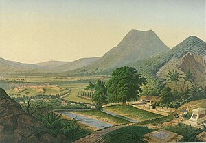
Fort Willem I is situated in the middle of a rice field. The main building is a pentagonal fort, sized around 178 x 178 meter. Small storage buildings are located around 94 meter away from the fort at each cardinal points.
Unlike earlier 18th-century fort designs, the 19th-century Willem I Fort were designed for a mainly defensive and logistical purpose. As such, the fort contains no embrasures or bastions. Instead, there are many windows in the rampart, and the bastions are detached from the fort. [1]

Central Java is a province of Indonesia, located in the middle of the island of Java. Its administrative capital is Semarang. It is bordered by West Java in the west, the Indian Ocean and the Special Region of Yogyakarta in the south, East Java in the east, and the Java Sea in the north. It has a total area of 34,337.48 km2, with a population of 36,516,035 at the 2020 Census making it the third-most populous province in both Java and Indonesia after West Java and East Java. The official estimate as at mid 2022 was 37,032,410. The province also includes a number of offshore islands, including the island of Nusakambangan in the south, and the Karimun Jawa Islands in the Java Sea.

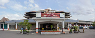
Surakarta, known colloquially as Solo, is a major city in Central Java, Indonesia. The 46.72 km2 city adjoins Karanganyar Regency and Boyolali Regency to the north, Karanganyar Regency and Sukoharjo Regency to the east and west, and Sukoharjo Regency to the south. On the eastern side of Solo lies Solo River. Its metropolitan area, consisting of Surakarta City and 59 districts spread over seven regencies, was home to 3,649,254 inhabitants as at the 2010 census, around half million of whom reside in the city proper.

The Sultanate of Mataram was the last major independent Javanese kingdom on the island of Java before it was colonised by the Dutch. It was the dominant political force radiating from the interior of Central Java from the late 16th century until the beginning of the 18th century.

Magelang is one of six cities in Central Java that are administratively independent of the regencies in which they lie geographically. Each of these cities is governed by a mayor rather than a bupati. Magelang city covers an area of 18.54 km2 and has a population of 118,227 at the 2010 census and 121,526 at the 2020 census; the official estimate as at mid 2022 was 121,675. It is located in the middle of the Magelang Regency, between Mount Merbabu and Mount Sumbing in Central Java Province, Indonesia, and lies 43 km north of Yogyakarta, 15 km north of Mungkid and 75 km south of Semarang, the capital of Central Java.
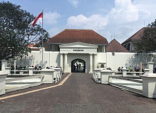
Fort Vredeburg Museum was a former colonial fortress located in the city of Yogyakarta, Special Region of Yogyakarta, Indonesia. The military complex has been converted into a museum of the Indonesian independence struggle which was opened in 1992. It is located in front of Gedung Agung and near the Kraton Yogyakarta.

The Great Post Road is the name for the historical road that runs across Java that connects Anyer and Panarukan. It was built during the reign of Herman Willem Daendels (1808–1811), governor-general of the Dutch East Indies, using unpaid forced labor that cost thousands of lives.

Ambarawa is a town located between the city of Semarang and Salatiga in Central Java, Indonesia. Administratively, it is bordered by the districts of Banyubiru to the south, Jambu to the west, Bandungan to the north, and Bawen to the east.
Herman Thomas Karsten was a Dutch engineer who gave major contributions to architecture and town planning in Indonesia during Dutch colonial rule. Most significantly he integrated the practice of colonial urban environment with native elements; a radical approach to spatial planning for Indonesia at the time. He introduced a neighborhood plan for all ethnic groups in Semarang, built public markets in Yogyakarta and Surakarta, and a city square in the capital Batavia. Between 1915 and 1941 he was given responsibility for planning 12 out of 19 municipalities in Java, 3 out of 9 towns in Sumatra and a town in Kalimantan. He received official recognition from both the government through his appointment to the colony's major Town Planning Committee and by the academic community with his appointment to the position of Lecturer for Town Planning at the School of Engineering at Bandung. He died in an internment camp near Bandung in 1945 during the Japanese occupation of the Dutch East Indies.

The Ambarawa Railway Museum is a museum located in Ambarawa in Central Java, Indonesia. The museum preserves around 21 steam locomotives and focusing on tourism train tour hauled by 3 operational steam engines and a hydraulic diesel engine, using the remains of the closing of the 3 ft 6 in (1,067 mm) railway line.

Surakarta Sunanate is a Javanese monarchy centred in the city of Surakarta, in the province of Central Java, Indonesia.

Brigadier General Ignatius Slamet Rijadi was an Indonesian soldier.

Albertus Soegijapranata, SJ, better known by his birth name Soegija, was a Jesuit priest who became the Apostolic Vicar of Semarang and later its archbishop. He was the first native Indonesian bishop and known for his pro-nationalistic stance, often expressed as "100% Catholic 100% Indonesian".
Most railway lines in Indonesia were constructed during the Dutch colonial rule. After independence in 1945, many lines were abandoned. The current national rail operator, PT Kereta Api Indonesia (Persero), was founded on 28 September 1945.

The Battle of Ambarawa was a battle between the recently created Indonesian Army and the British Army that occurred between 20 October and 15 December 1945 in Ambarawa, Indonesia.

Semarang Poncol Station (SMC) is a historic railway station in Purwosari, North Semarang, Semarang, Indonesia. The station which is located at an altitude of +3 meters is included in the Semarang Operational Area IV and is the second main station in Semarang after Semarang Tawang Station. It was built in 1914 and is considered an early example of Art Deco architecture.

The Naamlooze Vennootschap.Nederlandsch-Indische Spoorweg Maatschappij, abbreviated to NIS, NISM or N.V. NISM was a private-owned railways company in charge of rail transport in Java, Dutch East Indies. The company's headquarters were in Semarang, Central Java. The company started its maiden route from Semarang to Vorstenlanden and in 1873 they also built their line to the Willem I Railway Station of Ambarawa–Kedungjati and Batavia–Buitenzorg lines. Later the network expanded to Bandung and Surabaya. It was absorbed into the present Kereta Api Indonesia after Indonesian independence in 1945. It was the main competitor to Staatsspoorwegen as state-owned railway company and established on April 6, 1875.

Fort Vastenburg, also Fort Surakarta, is an 18th-century Dutch fort located in Gladak, Surakarta, Central Java, Indonesia. A landmark of Surakarta, the fort faces polemics related with multiple owners claiming different parts of the fort. As a result, the fort remains abandoned and threatened to be demolished by various private parties claiming the fort's ownership.
Fort Willem II of Ungaran is a late 18th-century fort built by the Dutch in Ungaran, Semarang Regency, Central Java, Indonesia. Its main purpose was to control an important trade route between Semarang and Yogyakarta. The fort is the place where Prince Diponegoro was imprisoned while waiting for his judgment in Batavia and further exile to Makassar. The fort is currently used as a dormitory for the families of Indonesian police personnel.

Kedungjati Station (KEJ) is a class III railway station located in Kedungjati District, Grobogan Regency, Central Java, Indonesia. The station is located at an altitude of +36 meters and is operated by Operation Area IV Semarang. The station once had a junction to Ambarawa Station until it was closed in 1976.