
The United States Virgin Islands, officially the Virgin Islands of the United States, are a group of Caribbean islands and an unincorporated and organized territory of the United States. The islands are geographically part of the Virgin Islands archipelago and are located in the Leeward Islands of the Lesser Antilles.

The United States Virgin Islands are a group of several dozen islands and cays located in the Caribbean, about 1,100 miles (1,770 km) southeast of Florida, 600 miles (966 km) north of Venezuela, 40 miles (64 km) east of Puerto Rico, and immediately west and south of the British Virgin Islands.

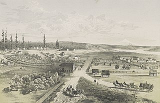
Charlotte Amalie, located on St. Thomas, is the capital and the largest city of the United States Virgin Islands. It was founded in 1666 as Taphus. In 1691, the town was renamed to Charlotte Amalie after the Danish queen Charlotte Amalie of Hesse-Kassel (1650–1714). It has a deep-water harbor that was once a haven for pirates and is now one of the busiest ports of call for cruise ships in the Caribbean, with about 1.5 million-plus cruise ship passengers landing there annually. Protected by Hassel Island, the harbor has docking and fueling facilities, machine shops, and shipyards and was a U.S. submarine base until 1966. The Town has been inhabited for centuries. When Christopher Columbus arrived in 1493, the area was inhabited by Caribs, Arawaks, Ciboney and Taíno native peoples. It is on the southern shore at the head of Saint Thomas Harbor. In 2010 the City had a population of 18,481, which makes it the largest city in the Virgin Islands Archipelago. Hundreds of ferries and yachts pass by the Town each week.

Saint Thomas is one of the Virgin Islands in the Caribbean Sea, and a constituent district of the United States Virgin Islands (USVI), an unincorporated territory of the United States. Along with surrounding minor islands, it is one of three county-equivalents in the USVI. Together with Saint John, it forms one of the districts of the USVI. The territorial capital and port of Charlotte Amalie is located on the island. As of the 2020 census, the population of Saint Thomas was 42,261, about 48.5% of the total population of the United States Virgin Islands. The island has a land area of 32 square miles (83 km2).

The Virgin Islands National Park is an American national park preserving about 60% of the land area of Saint John in the United States Virgin Islands, as well as more than 5,500 acres of adjacent ocean, and nearly all of Hassel Island, just off the Charlotte Amalie, Saint Thomas harbor.

Saint John is one of the Virgin Islands in the Caribbean Sea and a constituent district of the United States Virgin Islands (USVI), an unincorporated territory of the United States.
Fort Vancouver National Historic Site is a United States National Historic Site located in the states of Washington and Oregon. The National Historic Site consists of two units, one located on the site of Fort Vancouver in modern-day Vancouver, Washington; the other being the former residence of John McLoughlin in Oregon City, Oregon. The two sites were separately given national historic designation in the 1940s. The Fort Vancouver unit was designated a National Historic Site in 1961, and was combined with the McLoughlin House into a unit in 2003.
Water Island is a minor island in the United States Virgin Islands, an American territory located in the Caribbean Sea. The rest of the U.S. Virgin Islands were acquired by the Americans in 1917 from Denmark, however Water Island was excluded, thus the Danish East Asiatic Company, and by proxy the Danish kingdom, continued to own Water Island until several decades later. Water Island was bought by the American government in 1944, and in 1996 it was transferred to the U.S. Virgin Islands. The island is of volcanic origin and lies to the south of Saint Thomas in the Charlotte Amalie harbor. Ferry service runs regularly from Crown Bay, Saint Thomas to Phillips Landing, Water Island; the ferry ride is about 10 minutes.

Hassel Island is a small island of the U.S. Virgin Islands, a United States territory located in the Caribbean Sea. Hassel Island lies in the Charlotte Amalie harbor just south of Saint Thomas and east of Water Island, with which it is part of the sub-district of Water Island.

Christiansted National Historic Site commemorates urban colonial development of the Virgin Islands. It features 18th and 19th century structures in the heart of Christiansted, the capital of the former Danish West Indies on St. Croix Island.

The Legislature of the Virgin Islands is the territorial legislature of the United States Virgin Islands. The legislative branch of the unincorporated U.S. territory is unicameral, with a single house consisting of 15 senators, elected to two-year terms without term limits. The legislature meets in Charlotte Amalie on the island of St. Thomas.
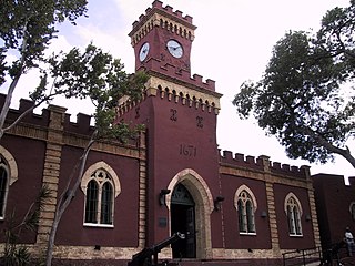
Fort Christian is a Dano-Norwegian-built fort in Charlotte Amalie, Saint Thomas, U.S. Virgin Islands. Built 1672-1680, early in the first successful colonial establishment on the island, the fort served as a critical point of defense and government during the entire period of Dano-Norwegian, and later Danish, administration, which ended in 1917 with the sale of the islands to the United States. It currently holds the St. Thomas Museum, which holds artifacts and art of the Dano-Norwegian period. It was designated a U.S. National Historic Landmark in 1977.

The following is an alphabetical list of articles related to the territory of the United States Virgin Islands.

Fort Frederik, also known as Frederiksfort, is a U.S. National Historic Landmark in Frederiksted, United States Virgin Islands. It was built between 1752 and 1760 by Denmark-Norway to defend the economic interests of the natural deep water port of Frederiksted and to ward off pirates. It has red and white painted walls, making it quite different then yellow and white of Fort Christiansværn on the other side of the island. It is located at the north end of Frederiksted, in St. Croix, south of the junction of Mahogany Road and VI 631. It should not be confused with Frederiks Fort, Fortberg Hill, on St. John, which is also listed on the National Register of Historic Places.

The Creque Marine Railway, formerly the "St Thomas Marine Repair Facility", is an inclined-plane ship railway on Hassel Island, in the bay of Charlotte Amalie off the coast of St. Thomas Island, in the U.S. Virgin Islands. Its site is below Fort Shipley, within Virgin Islands National Park.
St Thomas Historical Trust, is a non-profit historic preservation organization located on Saint Thomas island, in the United States Virgin Islands.

The Charlotte Amalie Historic District in Charlotte Amalie in Saint Thomas, U.S. Virgin Islands is a 165.3 acres (0.669 km2) historic district which was listed on the National Register of Historic Places in 1976.

Edith L. Williams was a United States Virgin Islands educator, women's rights activist, and suffragist. Williams was the first woman who attempted to vote in the Virgin Islands and when she was denied the right to register, she petitioned the court along with Eulalie Stevens and Anna M. Vessup to review their qualifications. They won their case and subsequently women throughout the Virgin Islands who were literate and property owners were allowed to vote. A bust of Williams was installed in the Franklin Delano Roosevelt Veterans Memorial Park in Charlotte Amalie, and the James Madison Elementary School was renamed as the Edith L. Williams School in 1981 in her honor.
The property known as Estate Niesky was purchased in 1755 by the Moravian Church in Charlotte Amalie, during the era when America's original Thirteen Colonies were still part of the British Empire. The United States would not take possession of the islands until March 31, 1917, at which time Denmark sold the islands for the sum of $25,000,000 in United States gold coin.

