Fountain Square, Indianapolis

Last updated
Fountain Square
Fountain Square Theatre in Indianapolis.jpg
Fountain Square Theatre Building and the Lady Spray Fountain in the foreground.
FountainSquareLogo.png
Motto: 
Anything but square [1]
Location map Indianapolis.png
Red pog.svg
Fountain Square
USA Indiana location map.svg
Red pog.svg
Fountain Square
Usa edcp location map.svg
Red pog.svg
Fountain Square
Coordinates: 39°45′8″N86°8′24″W / 39.75222°N 86.14000°W / 39.75222; -86.14000
Country United States
State Indiana
County Marion
Settled1835
Historic district 1983
Government
   Councillors Kristin Jones (D-17)
Zach Adamson (D-17)
Frank Mascari (D-21)
Population
  Estimate 
(2020) [2]
9,839
Time zone UTC-5 (Eastern (EST))
  Summer (DST) UTC-4 (EDT)
Zip code
46203
Website Discover Fountain Square

Fountain Square (abbreviated as FSQ) is one of seven designated cultural districts in Indianapolis, Indiana. Located just outside the city's downtown district, Fountain Square is home to three designated national historic districts, the Laurel and Prospect, the State and Prospect, and the Virginia Avenue districts, [3] all of which were listed on the National Register of Historic Places in 1983. [4] The neighborhood derives its name from the successive fountains that have been prominently featured at the intersection of Virginia Avenue, East Prospect Street, and Shelby Street. [5]

Contents

Fountain Square is the first commercial historic district in Indiana, [6] [7] [8] and it is the only portion of the city outside the initial mile square that has continually operated as a recognized commercial area since the 1870s. [9] Its significance is not only as an early commercial district, but additionally as one developed and dominated by German-American immigrants, merchants, and entrepreneurs, who established a strong German character on the city's southside. [10] From the 1920s to the 1950s, Fountain Square was the city's main entertainment district, [11] with as many as seven theaters in operation at one point in time. [12]

After the construction of the interstate through Indianapolis, a portion of Fountain Square was demolished, with the remaining neighborhood disconnected from the surrounding areas. [13] After decades of population decline, the neighborhood is estimated to have 9,839 inhabitants. [2] Historic preservation efforts began in the late 1990s, and the neighborhood slowly re-emerged as a vibrant commercial center. Today, Fountain Square is widely considered to be Indianapolis's newest trendy neighborhood, [7] with an eclectic mix of retro architecture and modern, urban design. [14]

Geography

Although Fountain Square is not officially delineated, the Fountain Square Neighborhood Association's service area is bounded to the north by the railroad tracks north of Deloss Street, to the east by State Street, to the south by Pleasant Run Parkway, and to the west by I-65. [1] [15] It is located 1.5 miles (2.4 km) southeast of downtown Indianapolis, and covers an area of approximately 1 square mile (2.6 km2). [8] [15] Little remains of the original geographic features of the land. [10]

Fountain Square bases a portion its street pattern due to a continuation of the diagonal Virginia Avenue, which came about from the 1821 Ralston Plan for the new city of Indianapolis. [10] The neighborhood is bordered upon by Bates–Hendricks to the southwest, Fletcher Place to the northwest, and Holy Cross neighborhood to the north. Within its boundaries, it houses the Laurel and Prospect, State and Prospect, and the Virginia Avenue historic districts. [3]

History

Early settlement

Prior to the arrival of Fountain Square's modern-day inhabitants, the area was inhabited by the Delaware people, who settled there after they were pushed out of their homeland along the Delaware River watershed. [16] After the Treaty of St. Mary's was signed on October 3, 1818, the Delaware ceded their lands in Indiana, which included a camp site at Pleasant Run, near Fountain Square's modern-day southern boundary. By 1820, the Delaware people were gone. [13]

The intersection of Virginia Avenue, Prospect, and Dillon (now Shelby) Streets in Indianapolis in 1876 Fountain Square, Indianapolis (map, 1876).png
The intersection of Virginia Avenue, Prospect, and Dillon (now Shelby) Streets in Indianapolis in 1876

In 1835, Calvin Fletcher, a banker, farmer and Indiana state senator, purchased a 264-acre (107 ha) farm with Nicholas McCarty, [17] with the intent to "sell the small parcels for a 'handsome advance'". [10] [18] While the early settlement was sparsely populated and primarily residential, the areas surrounding modern-day Fountain Square saw an influx of immigrants, particularly the Irish, who settled near the railroad tracks on South Street. Eventually, this area became known as "Irish Hill". [13] [19]

During the 1860s, the Virginia Avenue corridor began to emerge as the southside's commercial district. During the Civil War, the 28th Colored Infantry Regiment, which was the only black regiment formed in Indiana, trained at a wooded area at Indianapolis's Camp Fremont, on land owned by Calvin Fletcher. It included 518 enlisted men who signed on for three years of service. [20]

In 1864, the Citizen's Street Railway Company extended their mule-drawn streetcar down to the intersection of Virginia Avenue with Shelby and Prospect Streets, since the construction of the city's Union Station and its multiple railroad lines had cut the area off from the downtown district. [21] With the location of the streetcar turnaround, local residents nicknamed the neighborhood as "The End". [14] [17]

The years following Fletcher's death saw rapid commercial growth for the neighborhood, beginning in the 1870s. This development is attributed to the large number of German immigrants settling in the area, which helped to develop Fountain Square's distinctly German character. [14] [17] By 1870, Virginia Avenue was a bustling part of Indianapolis. Due to the rapid growth in population, the area was platted eight times from 1870 to 1873. [13] By 1880, single-family houses made up most of the lots off Virginia Avenue, although they were to be replaced by larger, commercial buildings in the following years. [22] In 1889, the first fountain was constructed, [18] giving Fountain Square its name. It was placed because a group of businessmen thought that "if they built a fountain, then maybe the farmers would stop and do business while they watered their animals." [18]

Continued growth

Postcard of the early 20th century depicting Fountain Square's streetcar rails, prior to the construction of the Fountain Square Theatre Fountain Square, Indianapolis (postcard).jpg
Postcard of the early 20th century depicting Fountain Square's streetcar rails, prior to the construction of the Fountain Square Theatre

Near the turn of the 20th century, Fountain Square saw an influx of many Eastern and Southern European immigrants moving into the neighborhood. [19] Fountain Square enjoyed continued growth as the southside's primary commercial district. The opening of the Fountain Square State Bank (1909), the Fountain Square Post Office (1927), Havercamp and Dirk's Grocery (1905), Koehring & Son Warehouse (1900), the Fountain Square branch of the Standard Grocery Company (1927), the Frank E. Reeser Company (1904), Wiese-Wenzel Pharmacy (1905), the Sommer-Roempke Bakery (1909), the Fountain Square Hardware Company (1912), Horuff & Son Shoe Store (1911), Jessie Hartman Milliners (1908), the William H. and Fiora Young Redman Wallpaper and Interior Design business (1923), the Charles F. Iske Furniture Store (1910), The Fountain Block Commercial Building (1902), and the G. C. Murphy Company (1929), are examples of this phenomenon.

In the early 1900s, Fountain Square's May Day celebration brought huge crowds into the neighborhood from all over the city to watch the parade and witness the festivities in nearby Garfield Park. [13]

One of the first trading centers outside of the Mile Square—some South Siders say the very first—developed here. The sons of merchants who were "on the fountain" before World War I maintain the family business, serving a new generation of families 'by the fountain.'
Gene Gladson,Indianapolis Theatres from A to Z, 1976 [4]

Following years of growth and expansion, the neighborhood's population reached an estimated 26,285 by 1930. [13] During World War II, Fountain Square experienced an influx of Appalachian settlers coming in from Kentucky and Tennessee, [19] who had moved to the city by the lure of the war industries that were operating in Indianapolis. [10] At that time, the majority of the population belonged to the white working-class, without a college education. [15] By 1950, Fountain Square's population had peaked to an estimated 27,242. [13] [23] At this time, Fountain Square was considered "downtown" for the southside areas of the city, offering multiple entertainment venues, a wide range of retail, shopping, church, and social centers. [24]

Decline

External video
YouTube Logo 2017.svg
Fountain Square c.1950
Nuvola apps kaboodle.svg Indiana Historical Society - Indianapolis Water Works Collection
Historical estimates
YearPop.±%
1930 26,285    
1950 27,242+3.6%
1970 19,736−27.6%
1980 15,941−19.2%
1990 13,903−12.8%
2020 [2] 9,839−29.2%
Source: The Polis Center, IUPUI [13]

However, the next decade saw the beginning of Fountain Square's demise, as newer more modern developments further south took over Fountain Square's role as the southside's commercial district. [17] The closing of all of the theaters exacerbated its economic and cultural demise. Symbolically, the fountain from which Fountain Square received its name was removed in 1954 due to traffic concerns, [21] to be returned in 1969 during a wave of revitalization efforts. [13] [25]

The State and Prospect District, among two others located within Fountain Square, was recognized as a historic district in 1983. State and Prospect District.jpg
The State and Prospect District, among two others located within Fountain Square, was recognized as a historic district in 1983.

During the 1960s, Indianapolis, along with the rest of the United States, experienced a great amount of societal upheaval, exacerbated by white flight after construction of the Interstate Highway System enabled many Americans to leave their industrial cities for new housing and shopping options in the suburbs. [12] [17] [26] In particular, the construction of the I-65 and I-70 interchanges from 1968 to 1971 had a negative effect on Fountain Square's population totals, as many of the neighborhood's multi-level flats and apartments were cleared to make way for the highway. In all, over 17,000 residents were displaced from the downtown areas, [13] 6,000 of which came from Fountain Square itself, totaling 25 percent of the neighborhood's population. [25]

In effect, this had cut Fountain Square's inhabitants off from downtown's social services and the adjacent neighborhoods, [13] [27] further exacerbating its population decline. By 1970, its population was an estimated 19,736, a decline of over 24 percent compared to the previous decade. [13] At that time, the minority population had risen to 6 percent. [13] For the next few decades, Fountain Square's population continued to decline, to 15,941 in 1980—a drop of almost 20 percent as compared to 1970 levels. [13]

Revitalization

Between 1980 and 1982, more than $3 million was invested in Fountain Square. [25] In 1983, three historic districts within Fountain Square were placed on the National Register of Historic Places, spurring a wave of corporate support, city grants, and private donations. [12] In 1984, the neighborhood was placed on the Indianapolis Historic Preservation Commission's list of adopted districts to focus on area rehabilitation. [13] By 1990, the population had dropped to 13,903, including a minority population of about 6.66 percent. [13]

A revitalized building on Prospect Street now houses a local Greek restaurant. 1413-1419 Prospect Street in Indianapolis.jpg
A revitalized building on Prospect Street now houses a local Greek restaurant.

In the 1990s, several neighborhood community organizations joined efforts to revitalize Fountain Square's former commercial center, resulting in the opening of several new restaurants, art galleries, retail and office places, and live entertainment venues. [28] In 1993, local resident Linton Calvert, a local barber and former city bowling champion, helped spur the transformation of Fountain Square through his purchase and subsequent restoration of the mostly vacant Fountain Square Theatre building, which up until that point housed a furniture store. [18] With his investment, the neighborhood benefited greatly, with reinvestment efforts that have continued up to this day. [17] In 1999, Indianapolis recognized Fountain Square as one of the city's six cultural districts. [29]

The designation of Fountain Square as one of Indianapolis's cultural districts has contributed to the neighborhood's rebirth. [17] Additional factors that have helped to cement the neighborhood's revitalization efforts are its compact and walkable streetscapes, unique building architecture, three historic district designations, its proximity to downtown, and ease of access from the interstates. [15] Upgrades to the neighborhood's streetscape, building rehabilitation, the construction of additional public spaces, and the placement of directional signs that visually define Fountain Square have also contributed to this process. [15] [17]

The neighborhood has been the scene of several home renovations on the television series Good Bones . [30]

Demographics

Because Fountain Square has not been delineated in past census counts, there are not any accurate population totals for the neighborhood. [31] The neighborhood's population peaked at an estimated 27,242 in 1950; however, the population dropped dramatically since then, and current estimates have placed that number at around 9,839. [2]

Demographic data for the neighborhood reveals a 72 percent increase of average home values from $47,000 in 2000 to $81,000 in 2013. [15] During that same time period, average rent prices have increased 82 percent, from $439 to $798. [15] The number of residents with college education has also increased, although poverty rates also increased and average income has declined. [15] Recently, Fountain Square has witnessed the effects of gentrification, as the average family income has increased 47 percent from 2010 to 2016. [32] Accordingly, the neighborhood's property values have increased, and the number of young professionals moving into the neighborhood has continued to climb. [28]

Transportation

IndyGo's bus rapid transit Red Line stop under construction. Fountain Square, Indianapolis (IndyGo stop).jpg
IndyGo's bus rapid transit Red Line stop under construction.

Fountain Square played an important role in the history and development of the city's transportation. [10] Historically, it was the last stop on Indianapolis's Virginia Avenue streetcar line. [33]

Today, Fountain Square is connected to IndyGo's bus rapid transit Red Line, which was opened in Summer 2019. [34] Projected to carry 11,000 daily passengers, the Red Line is a 13.5-mile (21.7 km) north–south transit line that connects the neighborhood with downtown and the Broad Ripple commercial district. [35] The neighborhood is also connected to downtown by the Indianapolis Cultural Trail, which is a multi-use trail that was inaugurated in 2013. An Indiana University Public Policy Institute report on the Cultural Trail estimated a $1 billion increase in property values along the route. [36]

The Cultural Trail “healed the cut” that I-65/70’s construction introduced, linking Fountain Square to downtown and other cultural districts and prioritizes landscape/ streetscape design elements.
Southeast Neighborhood Development Corporation [15]

Attractions

Fountain Square is home to several notable landmarks and attractions:

Fountain Square is one of the main settings for HGTV's Good Bones , a cable TV series that features a mother and daughter who focus on revitalizing and rehabbing homes in the Fountain Square, Bates–Hendricks, and other neighborhoods. [7] [40]

Related Research Articles

<span class="mw-page-title-main">Indianapolis</span> Capital of Indiana, United States

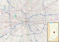
Indianapolis, colloquially known as Indy, is the capital and most populous city of the U.S. state of Indiana and the seat of Marion County. According to the 2020 United States census, the balance population was 887,642. It is the 16th-most populous city in the U.S., the third-most populous city in the Midwest after Chicago and Columbus, Ohio, and the fourth-most populous state capital after Phoenix, Arizona, Austin, Texas, and Columbus. The Indianapolis metropolitan area is the 33rd-most populous metropolitan statistical area in the U.S., with 2,111,040 residents. Its combined statistical area ranks 28th, with a population of 2,431,361. Indianapolis covers 368 square miles (950 km2), making it the 18th largest city by land area in the U.S.

<span class="mw-page-title-main">Greenwood, Indiana</span> City in Indiana, United States

Greenwood is a city in Johnson County, Indiana, United States. The population was 63,830 at the 2020 Census. Greenwood is located southeast of central Indianapolis between Indiana State Road 37 and Interstate 65. The city shares a border with Indianapolis and is the most populous suburban municipality in the southern portion of the Indianapolis Metropolitan Area.

<span class="mw-page-title-main">Downtown Cleveland</span> Central business district of Cleveland, Ohio, United States

Downtown Cleveland is the central business district of Cleveland, Ohio. The economic and symbolic center of the city and the Cleveland-Akron-Canton, OH Combined Statistical Area, it is Cleveland's oldest district, with its Public Square laid out by city founder General Moses Cleaveland in 1796.

<span class="mw-page-title-main">Garfield Park (Indianapolis)</span> Municipal park in Indianapolis, Indiana, U.S.

Garfield Park is a 128-acre (52 ha) urban park in Indianapolis, Indiana, United States. Established in the late 19th century, it is the oldest city park in Indianapolis and is on the National Register of Historic Places. The park is located at the confluence of Pleasant Run and Bean Creeks on the near Southside of Indianapolis. The 10,000-square-foot (930 m2) Conservatory and Sunken Gardens are located in the eastern portion of the park. The noted landscape architect George Edward Kessler designed the Sunken Gardens along with many of the other features of the park as part of his Park and Boulevard Plan for the city.

<span class="mw-page-title-main">Haughville, Indianapolis</span> United States historic place

Haughville is a neighborhood west of downtown Indianapolis. Its borders are roughly White River Parkway to the east, Tibbs Avenue to the west, 16th Street to the north, and Michigan Street to the south. It was first settled in the 1830s and grew after a bridge over White River was built connecting to Indianapolis, which annexed the town in 1897. The modern version of the bridge is also the connection between Haughville on the west side of the river and the Sidney & Lois Eskenazi Hospital and Indiana University - Purdue University Indianapolis on the east. The population in the late 1890s included Slovenian, German, and Irish immigrants, among other European immigrants. In the 21st century, the neighborhood suffers from a high crime rate and low property values.

<span class="mw-page-title-main">Irvington Historic District (Indianapolis)</span> Historic district in Indiana, United States

The neighborhood of Irvington, named after Washington Irving, includes Irvington Historic District, a historic district in Indianapolis, Indiana. The historic district is a 545-acre (221 ha) area that was listed on the National Register of Historic Places in 1987. That year, the district included 2,373 contributing buildings, 5 other contributing structures, and 2 contributing sites.

Indianapolis has seven designated neighborhoods as Cultural Districts, first established in 1999: Broad Ripple Village; Mass Ave; Fountain Square; Wholesale District; Canal and White River State Park; Indiana Avenue; and Market East. The purpose of these designations was to capitalize on cultural institutions within historically significant neighborhoods unique to the city's heritage for economic development and revitalization.

<span class="mw-page-title-main">Fletcher Place</span> United States historic place

Fletcher Place is a historic district and neighborhood in the city of Indianapolis, Indiana named after Calvin Fletcher, a prominent local banker, farmer and state senator.

<span class="mw-page-title-main">Downtown Indianapolis</span> Central business district of Indianapolis, Indiana, U.S.

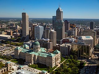
Downtown Indianapolis is a neighborhood area and the central business district of Indianapolis, Indiana, United States. Downtown is bordered by Interstate 65, Interstate 70, and the White River, and is situated near the geographic center of Marion County. Downtown has grown from the original 1821 town plat—often referred to as the Mile Square—to encompass a broader geographic area of central Indianapolis, containing several smaller historic neighborhoods.

The Bates–Hendricks neighborhood is situated just south and east of the downtown commercial district of Indianapolis, Indiana. The Fountain Square business district is just to the east.

<span class="mw-page-title-main">Downtown Fort Worth</span> Central business district in Texas, United States

Downtown Fort Worth is the central business district of Fort Worth, Texas, United States. Most of Fort Worth's tallest buildings and skyscrapers are located downtown.

<span class="mw-page-title-main">Old Northside Historic District</span> Historic district in Indiana, United States

Old Northside is a residential neighborhood near downtown in Indianapolis, Indiana. It is bordered by 16th Street on the north, Pennsylvania Street on the west, Interstate I-65 on the south, and Bellefontaine Street on the east. The Monon Trail runs along the eastern edge of The Frank and Judy O'Bannon Old Northside Soccer Park.

<i>Spaces with Iron</i> Artwork by Will Horwitt

Spaces with Iron is a public sculpture by American artist Will Horwitt. It was installed in January 2009 on the Indiana University-Purdue University Indianapolis (IUPUI) campus, near downtown Indianapolis, Indiana. The sculpture is located at the corner of Blackford and Vermont Streets, on the southeast lawn of the Science Building, and is on long-term loan from the Indianapolis Museum of Art.

<span class="mw-page-title-main">Virginia Avenue District</span> Historic district in Indiana, United States

Virginia Avenue District is a national historic district located at Indianapolis, Indiana. The district encompasses 43 contributing buildings and 1 contributing structure in the Fountain Square Commercial Areas of Indianapolis. It developed between about 1871 and 1932, and notable buildings include the Sanders (Apex) Theater (1913), Southside Wagon and Carriage Works / Saffel Chair Company, Fountain Square Theater (1928), Woessner Building, Granada Theater (1928), Southside Theater (1911), Schreiber Block (1895), Fountain Square State Bank (1922), and Fountain Bank (1902).

<span class="mw-page-title-main">Ransom Place Historic District</span> Historic district in Indiana, United States

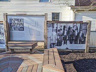
Ransom Place Historic District is a national historic district in Indianapolis, Indiana, United States. The district consists mainly of a six-square block in a historically Black residential section of Indianapolis, located just one block from Indiana Avenue. It was originally developed during the 1880s and 1890s, coinciding with the growth of Indiana Avenue as the central commercial district for Indianapolis's Black population at that time. It was listed on the National Register of Historic Places in 1992.

<span class="mw-page-title-main">Indianapolis Cultural Trail</span> Urban shared-use path and linear park in Indianapolis, Indiana, U.S.

The Indianapolis Cultural Trail, officially the Indianapolis Cultural Trail: A Legacy of Gene & Marilyn Glick, is an 8.1-mile-long (13.0 km) urban shared-use path and linear park located in the vicinity of downtown Indianapolis, Indiana. The trail is often compared to other popular bicycle and pedestrian paths across the U.S. and has inspired similar projects throughout the U.S. and Canada.

<span class="mw-page-title-main">Market East, Indianapolis</span> Cultural district in Indianapolis, Indiana, U.S.

Market East is the newest of seven designated cultural districts in Indianapolis, Indiana. The district is on the east side of downtown and is bounded to the north by New York Street, to the south by the railroad tracks, to the west by Delaware Street and to the east by East Street.

<span class="mw-page-title-main">The Idle</span> Park in Indianapolis, Indiana, U.S.

The Idle is a public park overlooking the I-65 and I-70 interstate interchanges in Indianapolis, Indiana. The park is located right off the Indianapolis Cultural Trail on Virginia Avenue, directly in-between the city's Fletcher Place and Fountain Square neighborhoods, which themselves are geographically separated by I-65.

<span class="mw-page-title-main">South Side Turnverein Hall</span> United States historic place

South Side Turnverein Hall is a historic social club and gymnasium in the Bates-Hendricks neighborhood of Indianapolis, Indiana, affiliated with the city's German-American community. It was built in 1900 by prominent architects Vonnegut & Bohn, whose managing partners Bernard Vonnegut, Sr. and Arthur Bohn were members of the burgeoning German-American community in Indianapolis. The architects were also known for designing the Athenæum, another German-American social club in the city. The South Side Turnverein was an important gathering place for Indianapolis' south side German community until its decline in the 1940s. It was sold to investors in 1978 to be used as an athletic club.

References

  1. 1 2 "Fountain Square". Downtown Indy. Retrieved 5 February 2020.
  2. 1 2 3 4 "Fountain Square". Niche. Retrieved 5 February 2020.
  3. 1 2 "Indiana State Historic Architectural and Archaeological Research Database (SHAARD)" (Searchable database). Department of Natural Resources, Division of Historic Preservation and Archaeology. Retrieved 2016-08-01.Note: This includes Mary Toshach; Mary Ellen Gadski; James Reed; Cecelia Boggs (February 1983). "National Register of Historic Places Inventory Nomination Form: Fountain Square Commercial Historic District" (PDF). Retrieved 2016-08-01. and Accompanying photographs
  4. 1 2 3 4 5 6 "National Register Information System". National Register of Historic Places . National Park Service . Retrieved 7 February 2020.
  5. "Historic & Conservation Districts". indy.gov. Retrieved 5 February 2020.
  6. "Fountain Square Commercial Areas TR". NPGallery Digital Asset Management System. National Park Service . Retrieved 5 February 2020.
  7. 1 2 3 Davis, Victoria T. (July 7, 2017). "7 things you'll only find in Fountain Square". RTV6 Indianapolis . Retrieved 5 February 2020.
  8. 1 2 3 "Homepage - Fountain Square Indy". Fountain Square Theatre Building. Retrieved 5 February 2020.
  9. Browne, Tiffany Benedict (November 26, 2011). "10 Reasons Fountain Square Would Be My Next Indianapolis Neighborhood…". Historic Indianapolis.com. Retrieved 5 February 2020.
  10. 1 2 3 4 5 6 "Historic Area Preservation Plan Fountain Square" (PDF). Indianapolis Historic Preservation Commission. January 1984. Retrieved 5 February 2020.
  11. Fenneman, Kate (April 2001). "Streetscape". Indianapolis Monthly. Emmis Communications: 30. Retrieved 5 February 2020.
  12. 1 2 3 Bodenhamer, David J. (November 22, 1994). The Encyclopedia of Indianapolis. Indiana University Press. p. 597. ISBN   0253112494 . Retrieved 5 February 2020.
  13. 1 2 3 4 5 6 7 8 9 10 11 12 13 14 15 16 "Fountain Square Neighborhood, Timeline: 1820-1997" (PDF). The Polis Center. IUPUI . Retrieved 5 February 2020.
  14. 1 2 3 Young, Julie (July 1, 2009). Eastside Indianapolis: A Brief History. Arcadia Publishing. ISBN   978-1625842619 . Retrieved 5 February 2020.
  15. 1 2 3 4 5 6 7 8 9 Anne Gadwa Nicodemus; Rachel Engh. "The Many Sides of Fountain Square" (PDF). Local Initiatives Support Corporation. Retrieved 5 February 2020.
  16. Vanderstel, Phd., David G. (1985). "Native Americans in Indiana". Conner Prairie Interpreter Resource Manual. Conner Prairie . Retrieved 6 February 2020.
  17. 1 2 3 4 5 6 7 8 "Fountain Square History". Discover Fountain Square. Retrieved 5 February 2020.
  18. 1 2 3 4 Knight, Mike (September 1999). "Square Deal". Indianapolis Monthly. p. 130. Retrieved 5 February 2020.
  19. 1 2 3 Baer, M. Teresa (2012). Indianapolis: A City of Immigrants. Indiana Historical Society. p. 56. ISBN   978-0871952998 . Retrieved 5 February 2020.
  20. "28th Regiment USCT". in.gov. Retrieved 7 February 2020.
  21. 1 2 "Virginia Avenue Historic District". National Park Service . Retrieved 5 February 2020.
  22. "The Old Fashioned Way at Fountain Square". IndyStar . August 29, 1984. Retrieved 5 February 2020.
  23. Ryan, Jordan (August 3, 2013). "Flats Saved: Virginia Avenue". Historic Indianapolis.com. Retrieved 5 February 2020.
  24. "History of Fountain Square". Fountain Square Theatre Building. Retrieved 5 February 2020.
  25. 1 2 3 "Fountain Square". The Polis Center. IUPUI . Retrieved 5 February 2020.
  26. Jackson, Kenneth T. (1985), Crabgrass Frontier: The Suburbanization of the United States , New York: Oxford University Press, ISBN   0-19-504983-7
  27. Ryan, Jordan (June 15, 2013). "Flats Lost: I-65 Construction". Historic Indianapolis.com. Retrieved 5 February 2020.
  28. 1 2 "City of Indianapolis Neighborhood Investment Strategy" (PDF). indy.gov. December 6, 2017. p. 99. Retrieved 6 February 2020.
  29. "History". Indianapolis Cultural Trail . Retrieved 5 February 2020.
  30. "About Two Chicks". Two Chicks & a Hammer. Retrieved 20 September 2021.
  31. "Fountain Square, Indiana". RoadsideThoughts. Retrieved 5 February 2020.
  32. "Neighborhood Change 1970-2016".
  33. Brennan, Maher (Spring 2013). "Indy Streetcar Comprehensive Project Proposal" (PDF). Ball State University. p. 18. Retrieved 5 February 2020.
  34. McLaughlin, Merritt (April 25, 2019). "Report: State of Downtown Indy Healthy". Inside Indian Business. Retrieved 5 February 2020.
  35. Freemark, Yonah (July 11, 2017). "The Bus Network Redesign in Indianapolis Will Be Like Launching a Brand New Transit System". Streetsblog USA. Retrieved 5 February 2020.
  36. Courage, Cara. "Why Indianapolis is a test case for a fairer form of gentrification". The Guardian . Retrieved 5 February 2020.
  37. "Murphy Arts Center". Deylen.com. Retrieved 7 February 2020.
  38. "Indianapolis Cultural Trail". Indianapolis Cultural Trail . Retrieved 7 February 2020.
  39. Mhatre, Amol (October 13, 2019). "The Idle: An oasis in the midst of traffic". CBS News . Retrieved 7 February 2020.
  40. "First Look: HGTV's 'Good Bones'". HGTV. May 5, 2015. Retrieved February 4, 2020.