
The Arroyo Seco Parkway, also known as the Pasadena Freeway, is one of the oldest freeways built in the United States. It connects Los Angeles with Pasadena alongside the Arroyo Seco seasonal river. It is notable not only for being an early freeway, mostly opened in 1940, but for representing the transitional phase between early parkways and modern freeways. It conformed to modern standards when it was built, but is now regarded as a narrow, outdated roadway. A 1953 extension brought the south end to the Four Level Interchange in downtown Los Angeles and a connection with the rest of the freeway system.

Route 110, consisting of State Route 110 (SR 110) and Interstate 110 (I-110), is a state and auxiliary Interstate Highway in the Los Angeles metropolitan area of the US state of California. The entire route connects San Pedro and the Port of Los Angeles with Downtown Los Angeles and Pasadena. The southern segment from San Pedro to I-10 in downtown Los Angeles is signed as I-110, while the northern segment to Pasadena is signed as SR 110. The entire length of I-110, as well as SR 110 south of the Four Level Interchange with US Route 101 (US 101), is the Harbor Freeway, and SR 110 north from US 101 to Pasadena is the historic Arroyo Seco Parkway, the first freeway in the western United States.

The Santa Ana Freeway is one of the principal freeways in Southern California, connecting Los Angeles and its southeastern suburbs including the freeway's namesake, the city of Santa Ana. The freeway begins at its junction with the San Diego Freeway, called the El Toro Y, in Irvine, signed as I-5. From there, it generally goes southeast to northwest to the East Los Angeles Interchange, where it takes the designation of U.S. Route 101 (US 101). It then proceeds 2.95 miles (4.75 km) northwest to the Four Level Interchange in downtown Los Angeles. Formerly, the entirety of the route was marked as US 101 until the 1964 highway renumbering, which truncated US 101 to the East Los Angeles Interchange and designated the rest of the freeway as I-5.

The Hollywood Freeway is one of the principal freeways of Los Angeles, California and one of the busiest in the United States. It is the principal route through the Cahuenga Pass, the primary shortcut between the Los Angeles Basin and the San Fernando Valley. It is considered one of the most important freeways in the history of Los Angeles and instrumental in the development of the San Fernando Valley. It is the second oldest freeway in Los Angeles. From its southern end at the Four Level Interchange to its intersection with the Ventura Freeway in the southeastern San Fernando Valley, it is signed as part of U.S. Route 101. It is then signed as State Route 170 north to its terminus at the Golden State Freeway.
The Ventura Freeway is a freeway in southern California, United States, running from the Santa Barbara/Ventura county line to Pasadena in Los Angeles County. It is the principal east–west route through Ventura County and in the southern San Fernando Valley in Los Angeles County. From the Santa Barbara County line to its intersection with the Hollywood Freeway in the southeastern San Fernando Valley in Los Angeles, it is signed as U.S. Route 101 (US 101), which was built in the late 1950s and opened on April 5, 1960. The segments from the Santa Barbara County line to Sea Cliff, and from Solimar Beach to Oxnard, are also concurrent with State Route 1 (SR 1), although actual signage mentioning SR 1 through these portions are nonexistent. East of the Hollywood Freeway intersection, the Ventura Freeway is signed as State Route 134 (SR 134), which was built by 1971.

State Route 163 (SR 163), or the Cabrillo Freeway, is a state highway in San Diego, California. The 11.088-mile (17.844 km) stretch of the former US 395 freeway runs from Downtown San Diego just south of an interchange with Interstate 5 (I-5), extending north through historic Balboa Park and various neighborhoods of San Diego to an interchange with I-15 in the neighborhood of Miramar. The freeway is named after Juan Rodríguez Cabrillo, the first European to navigate the coast of present-day California.

The East Los Angeles Interchange is an interchange complex located in Boyle Heights, Los Angeles, approximately 2.5 miles east of Downtown Los Angeles. With its southern portion handling over 550,000 vehicles per day, it is the busiest freeway interchange in the world. The northern portion, called the San Bernardino Split, is often considered a separate interchange. Four numbered routes converge at the interchange: Interstate 5 (I-5), I-10, U.S. Route 101 (US 101), and State Route 60 (SR 60), but the freeway segments shift alignments and directions.

Colorado Boulevard is a major east–west street in Southern California. It runs from Griffith Park in Los Angeles east through Glendale, the Eagle Rock section of Los Angeles, Pasadena, and Arcadia, ending in Monrovia. The full route was once various state highways but is now locally maintained in favor of the parallel Ventura Freeway and Foothill Freeway (I-210).

State Route 118 is a state highway in the U.S. state of California that runs west to east through Ventura and Los Angeles counties. It travels from State Route 126 at the eastern edge of Ventura immediately northwest of Saticoy, then through Saticoy, in Ventura County east to Interstate 210 near Lake View Terrace in Los Angeles. SR 118 crosses the Santa Susana Pass and the northern rim of the San Fernando Valley along its route.

The Southern California freeways are a vast network of interconnected freeways in the megaregion of Southern California, serving a population of 23 million people. The Master Plan of Metropolitan Los Angeles Freeways was adopted by the Regional Planning Commission in 1947 and construction began in the early 1950s. The plan hit opposition and funding limitations in the 1970s, and by 2004, only some 61% of the original planned network had been completed.

The Foothill Freeway is a freeway in the Los Angeles metropolitan area, California, United States, running from the Sylmar district of Los Angeles east to Redlands. The western segment is signed as Interstate 210 (I-210) from its western end at I-5 to SR 57 in Glendora, while the eastern segment is signed as State Route 210 (SR 210) to its eastern terminus at I-10. Under the California Streets and Highways Code, the entire Foothill Freeway is legally referred to as Route 210.
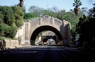
The Figueroa Street Tunnels are a set of four four-lane tunnels that carry northbound traffic on State Route 110 through Elysian Park in Los Angeles, California, United States. From south to north, the four tunnels measure 755, 461, 130, and 405 feet in length, 46.5 feet in width, and 28.3 ft in height.

State Route 47 is a state highway in the U.S. state of California, connecting Terminal Island to the mainland in the Los Angeles area. From its south end at I-110 in San Pedro, it heads east across the Vincent Thomas Bridge to the island and the end of state maintenance. The state highway begins again at the junction with I-710 on Terminal Island, crossing the Schuyler Heim Bridge north to the mainland and the second terminus, where SR 103 begins. Signage continues along a locally maintained route, mainly Alameda Street, to the Gardena Freeway in Compton, and an unconstructed alignment follows the same corridor to the Santa Monica Freeway (I-10) near downtown Los Angeles.
A directional interchange, colloquially known as a stack interchange, is a type of grade-separated junction between two controlled-access highways that allows for free-flowing movement to and from all directions of traffic. These interchanges eliminate the problems of weaving, have the highest vehicle capacity, and vehicles travel shorter distances when compared to different types of interchanges.
U.S. Route 101 (US 101) is a major north–south United States Numbered Highway, stretching from Los Angeles, California, to Tumwater, Washington. The California portion of US 101 is one of the last remaining and longest U.S. Routes still active in the state, and the longest highway of any kind in California. US 101 was also one of the original national routes established in 1926. Significant portions of US 101 between the Los Angeles area and the San Francisco Bay Area follow El Camino Real, the commemorative route connecting the former Alta California's 21 missions.
Interstate 10 (I-10) is a transcontinental Interstate Highway in the United States, stretching from Santa Monica, California, to Jacksonville, Florida. The segment of I-10 in California runs east from Santa Monica through Los Angeles, San Bernardino, and Palm Springs before crossing into the state of Arizona. In the Greater Los Angeles area, it is known as the Santa Monica and San Bernardino freeways, linked by a short concurrency on I-5 at the East Los Angeles Interchange. I-10 also has parts designated as the Rosa Parks and Sonny Bono Memorial freeways. Some parts were also formerly designated as the Christopher Columbus Transcontinental Highway. However, the California State Legislature removed this designation following the passage of a bill on August 31, 2022. I-10 is also known colloquially as "the 10" to Southern California residents (See also California English § Freeways).

U.S. Route 66 is a part of a former United States Numbered Highway in the state of California that ran from the west in Santa Monica on the Pacific Ocean through Los Angeles and San Bernardino to Needles at the Arizona state line. It was truncated during the 1964 renumbering and its signage removed in 1974. The highway is now mostly replaced with several streets in Los Angeles, State Route 2 (SR 2), SR 110, SR 66, San Bernardino County Route 66 (CR 66), Interstate 15 (I-15), and I-40.
Interstate 5 (I-5) is a major north–south route of the Interstate Highway System in the United States, stretching from the Mexican border at the San Ysidro crossing to the Canadian border near Blaine, Washington. The segment of I-5 in California runs 796.77 miles (1,282.28 km) across the length of the state from San Ysidro to the Oregon state line south of the Medford-Ashland metropolitan area. It is the longest interstate in California, and accounts for more than half of I-5's total length.

U.S. Route 6 (US 6) is a transcontinental United States Numbered Highway, stretching from Bishop, California, in the west to Provincetown, Massachusetts, in the east. The California portion of US 6 lies in the eastern portion of the state from Bishop in the Owens Valley north to the Nevada state line in Mineral County. Prior to the 1964 state highway renumbering, US 6 extended to the Pacific Ocean in Long Beach, California, as part of the historic auto trail named the Grand Army of the Republic Highway.

