Waikato is a region of the upper North Island of New Zealand. It covers the Waikato District, Waipa District, Matamata-Piako District, South Waikato District and Hamilton City, as well as Hauraki, Coromandel Peninsula, the northern King Country, much of the Taupō District, and parts of the Rotorua Lakes District. It is governed by the Waikato Regional Council.

Papakura District was a local council territory in New Zealand's Auckland Region that was governed by the Papakura District Council from 1989 until 2010. The area makes up the southernmost part of the Auckland metropolitan area.
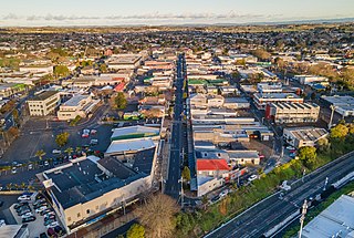
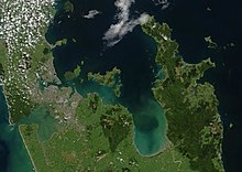
Pukekohe is a town in the Auckland Region of the North Island of New Zealand. Located at the southern edge of the Auckland Region, it is in South Auckland, between the southern shore of the Manukau Harbour and the mouth of the Waikato River. The hills of Pukekohe and nearby Bombay Hills form the natural southern limit of the Auckland region. Pukekohe is located within the political boundaries of the Auckland Council, following the abolition of the Franklin District Council on 1 November 2010.

Statistics New Zealand defines urban areas of New Zealand for statistical purposes. The urban areas comprise cities, towns and other conurbations of a thousand people or more. In combination, the urban areas of the country constitute New Zealand's urban population. As of June 2023, the urban population made up 90.8% of New Zealand's total population.

Waiuku is a rural town in the Auckland Region of New Zealand. It is located at the southern end of the Waiuku River, which is an estuarial arm of the Manukau Harbour, and lies on the isthmus of the Āwhitu Peninsula, which extends to the northeast. It is 40 kilometres southwest of Auckland city centre, and 12 kilometres north of the mouth of the Waikato River.

Auckland is one of the 16 regions of New Zealand, which takes its name from the eponymous urban area. The region encompasses the Auckland metropolitan area, smaller towns, rural areas, and the islands of the Hauraki Gulf. Containing 33 percent of the nation's residents, it has by far the largest population and economy of any region of New Zealand, but the second-smallest land area.

South Auckland is one of the major geographical regions of Auckland, the largest city in New Zealand. The area is south of the Auckland isthmus, and on the eastern shores of the Manukau Harbour. The area has been populated by Tāmaki Māori since at least the 14th century, and has important archaeological sites, such as the Ōtuataua stonefield gardens at Ihumātao, and Māngere Mountain, a former pā site important to Waiohua tribes.
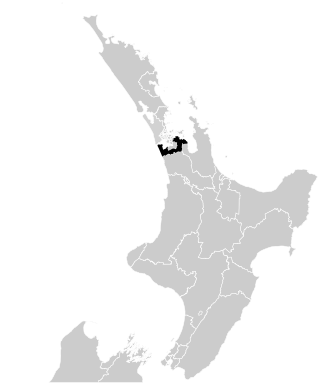
Port Waikato is a New Zealand parliamentary electorate which existed for four parliamentary terms from 1996 to 2008, and was recreated by the 2019/20 electoral redistribution ahead of the 2020 election. It was held by Bill Birch for one term, and by Paul Hutchison for the following three terms. From 2020, it was held by Andrew Bayly. All of these were members of the National Party.
The Hunua electorate existed three times for the New Zealand House of Representatives beginning in 1978, based at the south end of the Auckland urban area, and named for the Hunua Ranges. It covered different geographical areas over those periods. The electorate was last represented by Andrew Bayly of the National Party before its dissolution in 2020.

Ngāti Te Ata Waiohua is a Māori iwi from the area around the Manukau Harbour in the Auckland Region of New Zealand.

Auckland Libraries is the public library system for the Auckland Region of New Zealand. It was created when the seven separate councils in the Auckland region merged in 2010. It is currently the largest public-library network in the Southern Hemisphere with 55 branches from Wellsford to Waiuku. Currently from March 2021, the region has a total of 56 branches.

The Auckland Region of New Zealand is built on a basement of greywacke rocks that form many of the islands in the Hauraki Gulf, the Hunua Ranges, and land south of Port Waikato. The Waitākere Ranges in the west are the remains of a large andesitic volcano, and Great Barrier Island was formed by the northern end of the Coromandel Volcanic Zone. The Auckland isthmus and North Shore are composed of Waitemata sandstone and mudstone, and portions of the Northland Allochthon extend as far south as Albany. Little Barrier Island was formed by a relatively isolated andesitic volcano, active around 1 to 3 million years ago.
The Mangatangi River, or Mangatangi Stream, originates on the eastern slopes of the Hunua Ranges in New Zealand and flows roughly southwards until it is joined by the Ruaotehuia Stream just north of State Highway 2 between Mangatāwhiri and Maramarua, where it becomes the Maramarua River. Mangatangi can be translated as manga tangi to stream of weeping, or as rippling stream, or babbling brook.

The Āwhitu Peninsula is a long peninsula in the North Island of New Zealand, extending north from the mouth of the Waikato River to the entrance to Manukau Harbour.

The Franklin Local Board is one of the 21 local boards of the Auckland Council. It is overseen by the Franklin ward councillor.
Franklin is a local government area in the southernmost part of New Zealand's Auckland Region, governed by the Franklin Local Board and Auckland Council. It currently aligns with the council's Franklin Ward.

Āwhitu Regional Park is a regional park situated on the Āwhitu Peninsula, just south of Manukau Heads on the western side of the Manukau Harbour. It is situated in Franklin in Auckland in New Zealand's North Island, and is administered by Auckland Council.
The Counties Manukau cricket team represents the southern part of the Auckland Region, including the Auckland outer suburbs of Manurewa, Manukau and Papakura and the surrounding rural areas, and including Tuakau in the Waikato region. It competes in the Hawke Cup. Its base is in Manurewa, where its home ground is Weymouth Oval.

Portages in New Zealand, known in Māori as Tō or Tōanga Waka, are locations where waka (canoes) could easily be transported overland. Portages were extremely important for early Māori, especially along the narrow Tāmaki isthmus of modern-day Auckland, as they served as crucial transportation and trade links between the east and west coasts. Portages can be found across New Zealand, especially in the narrow Northland and Auckland regions, and the rivers of the Waikato Region.

The South Auckland volcanic field, also known as the Franklin Volcanic Field, is an area of extinct monogenetic volcanoes around Pukekohe, the Franklin area and north-western Waikato, south of the Auckland volcanic field. The field contains at least 82 volcanoes, which erupted between 550,000 and 1,600,000 years ago.