
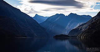
Fiordland is a geographical region of New Zealand in the south-western corner of the South Island, comprising the westernmost third of Southland. Most of Fiordland is dominated by the steep sides of the snow-capped Southern Alps, deep lakes, and its steep, glacier-carved and now ocean-flooded western valleys. The name "Fiordland" comes from a variant spelling of the Scandinavian word for this type of steep valley, "fjord". The area of Fiordland is dominated by, and very roughly coterminous with, Fiordland National Park, New Zealand's largest National Park.

Fiordland National Park is a national park in the south-west corner of South Island of New Zealand. It is the largest of the 13 national parks in New Zealand, with an area covering 12,607 km2 (4,868 sq mi), and a major part of the Te Wāhipounamu a UNESCO World Heritage Site established in 1990. The park is administered by the Department of Conservation. The southern ranges of the Southern Alps cover most of Fiordland National Park, combined with the deep glacier-carved valleys.

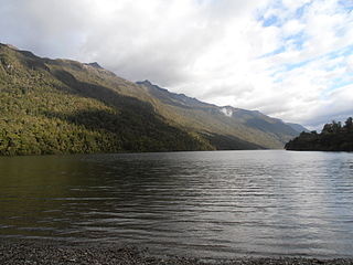
Lake Te Anau is in the southwestern corner of the South Island of New Zealand. The lake covers an area of 344 km2 (133 sq mi), making it the second-largest lake by surface area in New Zealand and the largest in the South Island. It is the second largest lake in Australasia by fresh water volume. The main body of the lake runs north-south, and is 65 km in length. Three large fiords form arms to the lake on its western flank: North Fiord, Middle Fiord and South Fiord. These are the only inland fiords that New Zealand has, the other 14 are out on the coast. Several small islands lie in the entrance to Middle Fiord, which forks partway along its length into northwest and southwest arms. The surface of the lake is at an altitude of 210 m. It has a maximum depth of 425 m, so much of its bed lies below sea level, with the deepest part of the lake being 215 metres below sea level.

Te Anau is a town in the Southland region of the South Island of New Zealand. In Māori, Te-Anau means the Place of the Swirling Waters. It is on the eastern shore of Lake Te Anau in Fiordland. Te Anau is 155 kilometres north of Invercargill and 171 kilometres to the southwest of Queenstown. Manapouri lies 21 kilometres to the south. Te Anau lies at the southern end of the Milford Road, 117 kilometres to the south of Milford Sound.

Manapouri is a small town in Southland / Fiordland, in the southwest corner of the South Island, in New Zealand. The township is the westernmost municipality in New Zealand. Located at the edge of the Fiordland National Park, on the eastern shore of Lake Manapouri, close to its outflow into the Waiau River, tourist boat services are based in the town.

Lake Hauroko is the deepest lake in New Zealand. The lake, which is 462 metres deep, is located in a mountain valley in Fiordland National Park.
Lake Alabaster / Wāwāhi Waka, also known by the Māori name of Waiwahuika, lies at the northern end of Fiordland, in the southwest of New Zealand's South Island. The lake runs from northeast to southwest, is five kilometres (3.1 mi), and covers seven km2 (2.7 sq mi).

The Te Ana-au caves are a culturally and ecologically important system of limestone caves on the western shore of Lake Te Anau, in the southwest of New Zealand. They were re-discovered in 1948 by Lawson Burrows, who found the upper entry after three years of searching, following clues in old Māori legends. It later became a major tourist attraction for the area, as the part of the caverns close to the lake shore is home to glowworms. The unofficial name used by the national caving association is Aurora. The caves are geologically young and hence there is only one tiny stalactite.

The Waiau River is the largest river in the Southland region of New Zealand. 'Waiau' translates to 'River of Swirling Currents'. It is the outflow of Lake Te Anau, flowing from it into Lake Manapouri 10 kilometres (6 mi) to the south, and from there flows south for 70 kilometres (43 mi) before reaching the Foveaux Strait 8 kilometres (5 mi) south of Tuatapere. It also takes water from Lake Monowai.

The Kepler Track is a 60 km (37 mi) circular hiking track which travels through the landscape of the South Island of New Zealand and is situated near the town of Te Anau. The track passes through many landscapes of the Fiordland National Park such as rocky mountain ridges, tall mossy forests, lake shores, deep gorges, rare wetlands and rivers. Like the mountains it traverses, the track is named after Johannes Kepler. The track is one of the New Zealand Great Walks and is administered by the Department of Conservation (DOC).

Pomona Island is the largest island within Lake Manapouri, in Fiordland National Park, in New Zealand's South Island. With an area of 262 hectares, it is the largest island to be found within any New Zealand lake.

Anchor Island is an island in Dusky Sound in Fiordland.

The Big River has also been known by several other names, Windsor River and Māori names Hakapoua, Okopowa, Patu-po, or Patupō, though that last name, meaning kill by night, might refer to a place near Long Point and Waitutu. It is a river of southern Fiordland, New Zealand, and is one of three rivers of that name in the South Island. It is the main source of Lake Hakapoua and a lower stretch is the lake's 2-kilometre (1.2 mi) outflow to the sea. The river rises on the 1,123 m (3,684 ft) high Arnett Peak, in the Cameron Mountains, runs about 23 km (14 mi) to the lake. At about the mid point of the river it runs through a narrow gorge. Elsewhere it is generally very shallow. The river is in the Fiordland National Park.

Southland is New Zealand's southernmost region. It consists mainly of the southwestern portion of the South Island and Stewart Island/Rakiura. It includes Southland District, Gore District and the city of Invercargill. Murihiku Southland is bordered by the culturally similar Otago to the north and east, and the West Coast in the extreme northwest. The region covers over 3.1 million hectares and spans 3,613 km of coast. As of June 2023, Southland has a population of 103,900, making it the eleventh-most-populous New Zealand region, and the second-most sparsely populated.
The Murchison Mountains are a group of mountains in Fiordland National Park in New Zealand. It is the location where the South Island takahē, a type of bird presumed extinct, was rediscovered in 1948. The highest mountain is Mount Lyall at 1,892 metres (6,207 ft).
Taiari / Chalky Inlet is one of the southernmost fiords in Fiordland, in the southwestern corner of New Zealand's South Island and part of Fiordland National Park. As with the neighbouring fiords of Tamatea / Dusky Sound to the north and Rakituma / Preservation Inlet to the south, Taiari / Chalky Inlet is a complex fiord with many channels and islands along its roughly 28 km (17 mi) length. Most notably, this includes the sections Moana-whenua-pōuri / Edwardson Sound and Te Korowhakaunu / Kanáris Sound, which split at Divide Head in the middle of Taiari and each extend for roughly 10 km (6.2 mi) inland in a V-shape.

RealNZ is a New Zealand tourism company based in Queenstown. The company offers a range of travel, cruises and excursions in Queenstown, Milford Sound / Piopiotahi, Te Anau, Fiordland and Stewart Island / Rakiura. It also operates two skifields Cardrona Alpine Resort, and Treble Cone, and the International Antarctic Centre in Christchurch. The company is the successor of a series of acquisitions in the South Island tourist sector over more than 60 years. The brand RealNZ was launched in October 2021 to bring together multiple brands and businesses including Real Journeys that were previously part of the Wayfare Group, although some of the businesses have retained individual branding.

Te Tapuwae o Hua Marine Reserve is a marine reserve covering an area of 3,672 hectares in Te Awaroa / Long Sound in Fiordland on New Zealand's South Island. It was established in 2005 and is administered by the Department of Conservation.
Moana Uta Marine Reserve is a marine reserve covering the entire length of Wet Jacket Arm in Fiordland on New Zealand's South Island, an area of 2,007 hectares. It was established in 2005 and is administered by the Department of Conservation.
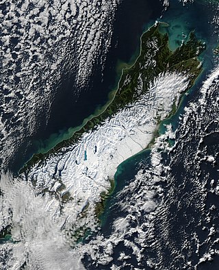
The South Island, with an area of 150,437 km2 (58,084 sq mi), is the largest landmass of New Zealand; it contains about one-quarter of the New Zealand population and is the world's 12th-largest island. It is divided along its length by the Southern Alps, the highest peak of which is Aoraki / Mount Cook at 3,724 metres (12,218 ft), making it 9th-highest island, with the high Kaikōura Ranges to the northeast. There are eighteen peaks of more than 3,000 metres (9,800 ft) in the South Island. The east side of the island is home to the Canterbury Plains while the West Coast is famous for its rough coastlines such as Fiordland, a very high proportion of native bush, and Fox and Franz Josef Glaciers. The dramatic landscape of the South Island has made it a popular location for the production of several films, including The Lord of the Rings trilogy and The Chronicles of Narnia: The Lion, the Witch and the Wardrobe. It lies at similar latitudes to Tasmania, and parts of Patagonia in South America.
