
Brooke County is a county in the Northern Panhandle of the U.S. state of West Virginia. As of the 2010 census, the population was 24,069. Its county seat is Wellsburg. The county was created in 1797 from part of Ohio County and named in honor of Robert Brooke, Governor of Virginia from 1794 to 1796.
Franklintown is a borough in York County, Pennsylvania, United States. The population was 489 at the 2010 census.

The Shenandoah Valley is a geographic valley and cultural region of western Virginia and the Eastern Panhandle of West Virginia in the United States. The valley is bounded to the east by the Blue Ridge Mountains, to the west by the eastern front of the Ridge-and-Valley Appalachians, to the north by the Potomac River and to the south by the James River. The cultural region covers a larger area that includes all of the valley plus the Virginia highlands to the west, and the Roanoke Valley to the south. It is physiographically located within the Ridge and Valley province and is a portion of the Great Appalachian Valley.

The Eastern Panhandle is the eastern of the two panhandles in the U.S. state of West Virginia. It is a small stretch of territory in the northeast of the state, bordering Maryland and Virginia. Some sources and regional associations only identify the Eastern Panhandle as being composed of Morgan, Berkeley, and Jefferson Counties. Berkeley and Jefferson Counties are geographically located in the Shenandoah Valley. West Virginia is unusual in having two panhandles, the Eastern Panhandle and the Northern Panhandle.
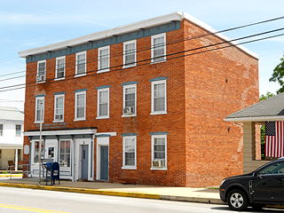
Franklintown may refer to some places in the United States:

The West Virginia Senate is the upper house of the West Virginia Legislature. There are seventeen senatorial districts. Each district has two senators who serve staggered four-year terms.

This is a list of properties and historic districts in West Virginia that are listed on the National Register of Historic Places. There are listings in every one of West Virginia's 55 counties.

The U.S. state of West Virginia was formed out of western Virginia and added to the Union as a direct result of the American Civil War, in which it became the only state to declare its independence from the Confederacy. In the summer of 1861, Union troops, which included a number of newly-formed Western Virginia regiments, under General George McClellan, drove off Confederate troops under General Robert E. Lee. This essentially freed Unionists in the northwestern counties of Virginia to form a functioning government of their own as a result of the Wheeling Convention. Prior to the admission of West Virginia the government in Wheeling formally claimed jurisdiction over all of Virginia, although from its creation it was firmly committed to the formation of a separate state.
Franklintown is an unincorporated community in Nassau County, Florida, United States. It is located in the southern half of Amelia Island, on A1A near the Amelia River.
Franklin, Pennsylvania may refer to:

Lewisville is an unincorporated community in northern Clarke County, Virginia. Lewisville lies on Lewisville Road to the southwest of Franklintown, West Virginia.
Rosemont is a neighborhood in the western part of Baltimore, Maryland. Located below North Avenue, above Franklintown Road, East of Hilton Parkway, and West of Bloomingdale Avenue it is a working class African-American neighborhood.

Franklintown Historic District is a national historic district in Baltimore, Maryland, United States. It is the result of a plan developed in 1832 by William H. Freeman (1790-1863), a local politician and entrepreneur. His plan evolved gradually over the course of several decades and owes its success to his untiring promotion of the village. The central feature is an oval plan with radiating lots around a central wooded park. The district includes an old stone grist mill known as Franklin Mill, the innovative radiating oval plan, and the associated hotel and commercial area. The key residential buildings are excellent examples of the "I"-house form and display steeply pitched cross gables found in vernacular rural buildings throughout much of Maryland.

Gywnns Falls Trail is a 15-mile (24 km) series of hiking and bicycling trails inside Baltimore, Maryland, named for the Gwynns Falls, whose course it follows, and the surrounding Gwynns Falls Leakin Park it passes through. The trail uses unique alignments, sidepaths on existing streets, and on-street sections. The trail consists of one 10.75-mile (17.30 km) mainline, plus a number of branches, including the Middle Branch Trail, the Hutton Trail, and the Dickeyville Trail. All of these trails carry signage designating them as the Gwynns Falls Trail; their individual names are designated via pavement markers designating their route. The entirety of the Middle Branch Trail, as well as the section of the mainline trail east of the Middle Branch Trail's northern terminus, are part of the East Coast Greenway.

West Hills is a neighborhood in the Southwest District of Baltimore, located between the neighborhoods of Westgate (south), Franklintown (north) and Hunting Ridge (east). Its boundaries are drawn by the Baltimore County line (west), Baltimore National Pike (south) and North Franklintown Road (north). Its eastern boundary follows Cooks Lane from Baltimore National Pike, then Briarclift Road and finally Wynans Way to the intersection with N. Franklintown Road.


