
The Ohio River is a 981-mile (1,579 km) long river in the midwestern United States that flows southwesterly from western Pennsylvania south of Lake Erie to its mouth on the Mississippi River at the southern tip of Illinois. It is the second largest river by discharge volume in the United States and the largest tributary by volume of the north-south flowing Mississippi River that divides the eastern from western United States. The river flows through or along the border of six states, and its drainage basin includes parts of 15 states. Through its largest tributary, the Tennessee River, the basin includes several states of the southeastern U.S. It is the source of drinking water for three million people.
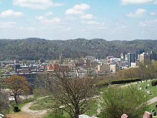
Charleston is the most populous city in, and the capital of, the U.S. state of West Virginia. Located at the confluence of the Elk and Kanawha rivers, the population during the 2017 Census Estimate was 47,929. The Charleston metropolitan area as a whole had 214,406 residents. Charleston is the center of government, commerce, and industry for Kanawha County, of which it is the county seat.

The Potomac River is located within the Mid-Atlantic region of the United States and flows from the Potomac Highlands into the Chesapeake Bay. The river is approximately 405 miles (652 km) long, with a drainage area of about 14,700 square miles (38,000 km2). In terms of area, this makes the Potomac River the fourth largest river along the Atlantic coast of the United States and the 21st largest in the United States. Over 5 million people live within the Potomac watershed.
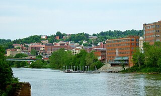
Morgantown is a city in and the county seat of Monongalia County, West Virginia, United States, situated along the banks of the Monongahela River. It is known as the home of West Virginia University and the Morgantown Personal Rapid Transit (PRT) system. With a permanent population of 31,073 per the 2015 U.S. Census estimates, Morgantown is the largest city in North-Central West Virginia. The Morgantown metropolitan area has a population of 138,176.

The Shenandoah Valley is a geographic valley and cultural region of western Virginia and the Eastern Panhandle of West Virginia in the United States. The valley is bounded to the east by the Blue Ridge Mountains, to the west by the eastern front of the Ridge-and-Valley Appalachians, to the north by the Potomac River and to the south by the James River. The cultural region covers a larger area that includes all of the valley plus the Virginia highlands to the west, and the Roanoke Valley to the south. It is physiographically located within the Ridge and Valley province and is a portion of the Great Appalachian Valley.

West Virginia University (WVU) is a public, land-grant, space-grant, research-intensive university in Morgantown, West Virginia, United States. Its other campuses include the West Virginia University Institute of Technology in Beckley and Potomac State College of West Virginia University in Keyser; and a second clinical campus for the University's medical and dental schools at Charleston Area Medical Center in Charleston. WVU Extension Service provides outreach with offices in all of West Virginia's 55 counties. Since 2001, WVU has been governed by the West Virginia University Board of Governors.

The Monongahela River — often referred to locally as the Mon — is a 130-mile-long (210 km) river on the Allegheny Plateau in north-central West Virginia and southwestern Pennsylvania. The river flows from the confluence of its west and east forks in north central West Virginia northeasterly into southwestern Pennsylvania, then northerly to Pittsburgh and its confluence with the Allegheny River to form the Ohio River. The river is navigable its entire length via a series of locks and dams.

The flag of West Virginia is the official flag of the U.S. state of West Virginia and was officially adopted by the West Virginia Legislature on March 7, 1962. The present flag consists of a pure white field bordered by a blue stripe with the coat of arms of West Virginia in the center, wreathed by Rhododendron maximum and topped by an unfurled red ribbon reading "State of West Virginia."

The Allegheny Mountain Range, informally the Alleghenies and also spelled Alleghany and Allegany, is part of the vast Appalachian Mountain Range of the Eastern United States and Canada and posed a significant barrier to land travel in less technologically advanced eras. The barrier range has a northeast–southwest orientation and runs for about 400 miles (640 km) from north-central Pennsylvania, through western Maryland and eastern West Virginia, to southwestern Virginia.

Marshall University is a public research university in Huntington, West Virginia. It was founded in 1837 and is named after John Marshall, the fourth Chief Justice of the United States.

These are tables of congressional delegations from West Virginia to the United States House of Representatives and the United States Senate.
West Virginia Public Broadcasting (WVPB) is the public television and radio state network serving the U.S. state of West Virginia. It is owned by the West Virginia Public Broadcasting Authority, an agency of the West Virginia state government that holds the licenses for all Public Broadcasting Service (PBS) and National Public Radio (NPR) member stations licensed in West Virginia. It is headquartered in Charleston with studios in Morgantown and Beckley.

West Virginia Wesleyan College is a private, coeducational, liberal arts college in Buckhannon, West Virginia, United States. It has an enrollment of about 1,400 students from 35 U.S. states and 26 countries. The school was founded in 1890 by the West Virginia Conference of the United Methodist church.

The West Virginia Mountaineers football team represents West Virginia University in the NCAA Football Bowl Subdivision (FBS) of college football. West Virginia plays its home games on Mountaineer Field at Milan Puskar Stadium on the campus of West Virginia University in Morgantown, West Virginia. The Mountaineers compete in the Big 12 Conference.

The Huntington–Ashland metropolitan area is the largest metropolitan statistical area in West Virginia and includes seven counties across three states: West Virginia, Kentucky, and Ohio. New definitions from February 28, 2013 placed the population at 361,580. The MSA is nestled along the banks of the Ohio River within the Appalachian Plateau region. The area is referred to locally as the "Tri-State area". In addition, the three largest cities are referred to as the River Cities.
The West Virginia Department of Transportation is the state agency responsible for transportation in West Virginia. The Department of Transportation serves an umbrella organization for seven subsidiary agencies which are directly responsible for different areas of the state's infrastructure.


