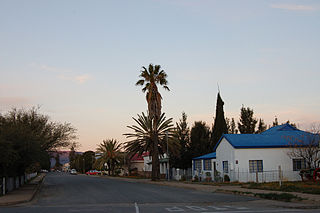
Top: skyline of Fraserburg at dusk. Left: the Dutch Reformed Church on the main street. Middle right: town's post office. Bottom right: a corbelled house built by Trekboers before the town was established.
A particularly good example of a corbelled house can be found in the town, there are others in the district. The town is also well known for the large number of unique and well-preserved fossil finds that litter the surrounding area.
History
A photograph down the main road running from Leeu Gamka of the old Dutch Reformed Church in 1899.
The earliest known inhabitants of the area were the San people and their artefacts and rock paintings can still be found in the area. The first Europeans to arrive in the region were Trekboers who arrived in 1759. The first settler to be recorded in these parts was Willem Steenkamp, after whom the Steenkampsberg is named.[2] In 1851 Fraserburg was established on the farm Rietfontein and named after the Scottish immigrant Reverend Colin Fraser.[3]
A post office was established in 1858, seven years after the town's founding, this led to an era of development for the area. In 1859 a magistrates office was opened and in 1860 a police station was opened and the town's first medical doctor arrived. In 1861 a prison was opened in the town, it closed 107 years later in 1968. In 1870 the town's first attorney and noted Afrikaans author, H. W. A. Cooper, moved to the town where he wrote the "Boerebrieven" in the Afrikaans newspaper Het Volksblad, writing under the pseudonym Samuel Zwaartman.[4]
The town was declared a municipality on June 6, 1862.[4]
There are many Victorian era houses in the town dating to the era of the ostrich feather and wool booms of the late 19th and early 20th centuries.
In 1861 the town's distinctive hexagonal stone bell tower was built. Known as The Pepperpot due to its distinctive shape, the 9 meter tall structure and was used as the magistrate’s private office, the Market Master’s office and functioned as the town's first library.[5]
In 1870 a powder magazine, which still stands on the edge of town, was built by the British army in case of war with the neighbouring Griqua people and was used during the Anglo-Boer War. In 1938 the town's first power station was installed with 7 Lister Blackstone generators -still present- used to power the town at the time it was connected to the national grid in 1983.[6]
Fossil deposits
In 1968 on a nearby farm a number of very well preserved fossilised footsteps were discovered dating back 250 million years to the Permian Period, most notable of which is a very well preserved Bradysaurus footprint.[7] Since then a number of fossilised remains of other pre-dinosaur creatures such as Pareiasaurs, Dinocephalians, and Therapsids have been discovered in an area regarded as one of the best paleontological sites in South Africa.[8]
Fossils of some of the following Permian period reptiles have been found in the area:
Fraserburg has an average yearly temperature of 13.9°C and an average annual minimum temperature of 6°C; Snowfall is common in winter. On average the town's warmest month is January with an average temperature of 21.7°C, the coolest month tends to be June, with an average temperature of 6.7°C. Fraserburg has a Tropical and Subtropical Desert Climate (Köppen climate classificationBWk).
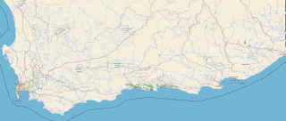
South Africa occupies the southern tip of Africa, its coastline stretching more than 2,850 kilometres from the desert border with Namibia on the Atlantic (western) coast southwards around the tip of Africa and then northeast to the border with Mozambique on the Indian Ocean. The low-lying coastal zone is narrow for much of that distance, soon giving way to a mountainous escarpment that separates the coast from the high inland plateau. In some places, notably the province of KwaZulu-Natal in the east, a greater distance separates the coast from the escarpment. Although much of the country is classified as semi-arid, it has considerable variation in climate as well as topography. The total land area is 1,220,813 km2 (471,359 sq mi). It has the 23rd largest Exclusive Economic Zone of 1,535,538 km2 (592,875 sq mi).
The Western Cape is a province of South Africa, situated on the south-western coast of the country. It is the fourth largest of the nine provinces with an area of 129,449 square kilometres (49,981 sq mi), and the third most populous, with an estimated 7 million inhabitants in 2020. About two-thirds of these inhabitants live in the metropolitan area of Cape Town, which is also the provincial capital. The Western Cape was created in 1994 from part of the former Cape Province. The two largest cities are Cape Town and George.
Mossel Bay is a harbour town of about 99,000 people on the Southern Cape of South Africa. It is an important tourism and farming region of the Western Cape Province. Mossel Bay lies 400 kilometres east of the country's seat of parliament, Cape Town, and 400 km west of Port Elizabeth, the largest city in the Eastern Cape. The older parts of the town occupy the north-facing side of the Cape St Blaize Peninsula, whilst the newer suburbs straddle the Peninsula and have spread eastwards along the sandy shore of the Bay.
The Northern Cape is the largest and most sparsely populated province of South Africa. It was created in 1994 when the Cape Province was split up. Its capital is Kimberley. It includes the Kalahari Gemsbok National Park, part of the Kgalagadi Transfrontier Park and an international park shared with Botswana. It also includes the Augrabies Falls and the diamond mining regions in Kimberley and Alexander Bay.
The Karoo is a semi-desert natural region of South Africa. No exact definition of what constitutes the Karoo is available, so its extent is also not precisely defined. The Karoo is partly defined by its topography, geology and climate, and above all, its low rainfall, arid air, cloudless skies, and extremes of heat and cold. The Karoo also hosted a well-preserved ecosystem hundreds of million years ago which is now represented by many fossils.
The Garden Route is a 300-kilometre (190 mi) stretch of the south-eastern coast of South Africa which extends from Witsand in the Western Cape to the border of Tsitsikamma Storms River in the Eastern Cape. The name comes from the verdant and ecologically diverse vegetation encountered here and the numerous estuaries and lakes dotted along the coast. It includes towns such as Knysna, Plettenberg Bay, Mossel Bay, Oudtshoorn, Great Brak River, Little Brak River, Wilderness, Sedgefield and Nature's Valley; with George, the Garden Route's largest city and main administrative centre.
Beaufort West Local Municipality is a municipality located in Western Cape Province, South Africa. As of 2011 the population is 49,586. Its municipality code is WC053.
Sutherland is a town with about 2,841 inhabitants in the Northern Cape province of South Africa. It lies in the western Roggeveld Mountains in the Karoo.
The Karoo Supergroup is the most widespread stratigraphic unit in Africa south of the Kalahari Desert. The supergroup consists of a sequence of units, mostly of nonmarine origin, deposited between the Late Carboniferous and Early Jurassic, a period of about 120 million years.
Beaufort West is a town in the Western Cape province in South Africa. It is the largest town in the arid Great Karoo region, and is known as the "Capital of the Karoo". It forms part of the Beaufort West Local Municipality, with 34,085 inhabitants in 2011.
Anteosaurus is an extinct genus of large carnivorous dinocephalian synapsid. It lived at the end of the Guadalupian during the Capitanian stage, about 265 to 260 million years ago in what is now South Africa. It is mainly known by cranial remains and few postcranial bones. With its skull reaching 80–90 cm (31–35 in) in length and a body size estimated at more than 5 m (16 ft) in length, and 500 to 600 kg in weight, Anteosaurus was the largest known carnivorous non-mammalian synapsid and the largest terrestrial predator of the Permian period. Occupying the top of the food chain in the Middle Permian, its skull, jaws and teeth show adaptations to capture large prey like the giants titanosuchids and tapinocephalids dinocephalians and large pareiasaurs.
The Tapinocephalus Assemblage Zone is a tetrapod assemblage zone or biozone which correlates to the middle Abrahamskraal Formation, Adelaide Subgroup of the Beaufort Group, a fossiliferous and geologically important geological Group of the Karoo Supergroup in South Africa. The thickest outcrops, reaching approximately 2,000 metres (6,600 ft), occur from Merweville and Leeu-Gamka in its southernmost exposures, from Sutherland through to Beaufort West where outcrops start to only be found in the south-east, north of Oudshoorn and Willowmore, reaching up to areas south of Graaff-Reinet. Its northernmost exposures occur around the towns Fraserburg and Victoria West. The Tapinocephalus Assemblage Zone is the second biozone of the Beaufort Group.
Anomocephalus is an extinct genus of primitive anomodonts and belongs to the clade Anomocephaloidea. The name is said to be derived from the Greek word anomos meaning lawless and cephalos meaning head. The proper word for head in Greek is however κεφαλή (kephalē). It is primitive in that it retains a complete set of teeth in both jaws, in contrast to its descendants, the dicynodonts, whose dentition is reduced to only a single pair of tusks, with their jaws covered by a horny beak similar to that of a modern tortoise. However, they are in no way closely related.
Karoo Hoogland is an administrative area in the Namakwa District of Northern Cape in South Africa.
Molteno is a town in the Eastern Cape province of South Africa.
Calvinia is a regional town in the Northern Cape province of South Africa named after the French religious reformer Jean Calvin. The town falls under the Hantam Local Municipality which forms part of the Namakwa District Municipality. The Calvinia district is part of the Great Karoo region of South Africa. The town is just south of the Hantam mountains on the banks of the Oorlogskloof River.
Leeu-Gamka is a small town in the Western Cape province of South Africa, located 355 kilometres (221 mi) north-east of Cape Town in the Karoo.
The Abrahamskraal Formation is a geological formation and is found in numerous localities in the Northern Cape, Western Cape, and the Eastern Cape of South Africa. It is the lowermost formation of the Adelaide Subgroup of the Beaufort Group, a major geological group that forms part of the greater Karoo Supergroup. It represents the first fully terrestrial geological deposits of the Karoo Basin. Outcrops of the Abrahamskraal Formation are found from the small town Middelpos in its westernmost localities, then around Sutherland, the Moordenaarskaroo north of Laingsburg, Williston, Fraserburg, Leeu-Gamka, Loxton, and Victoria West in the Western Cape and Northern Cape. In the Eastern Cape outcrops are known from Rietbron, north of Klipplaat and Grahamstown, and also southwest of East London.
The Northern Cape Heritage Resources Authority, previously called Ngwao Boswa jwa Kapa Bokone, and commonly known as 'Boswa', is a provincial heritage resources authority established in 2003 by the MEC for Sport, Arts and Culture in the Northern Cape Province of South Africa, and reconstituted in terms of the Northern Cape Heritage Resources Authority Act, 2013. It is an institution set up under the terms of the National Heritage Resources Act. It is mandated to care for that part of South Africa's national estate that is of provincial and local significance in the Northern Cape.
The Teekloof Formation is a geological formation that forms part of the Beaufort Group, one of the five geological groups that comprises the Karoo Supergroup in South Africa. The Teekloof Formation is the uppermost formation of Adelaide Subgroup deposits West of 24ºE and contains Middle to Late Permian-aged deposits and four biozones of the Beaufort Group. It overlies the Abrahamskraal Formation. The Teekloof Formation does not underlie other units other than the younger Karoo dolerites and sills that relate to the emplacement of the Early Jurassic Drakensberg Group to the east. Outcrops and exposures of the Teekloof Formation range from Sutherland through the mountain escarpments between Fraserburg and Beaufort West. The northernmost localities of the Teekloof Formation are found by Loxton, Victoria West and Richmond.
This page is based on this Wikipedia article Text is available under the CC BY-SA 4.0 license; additional terms may apply. Images, videos and audio are available under their respective licenses.