
Frenchtown is a primarily African American neighborhood in Tallahassee, Florida. It is the oldest such neighborhood in the state.
Frenchtown is a primarily African American neighborhood in Tallahassee, Florida. It is the oldest such neighborhood in the state.
Frenchtown originated from 19th century settlers who moved to the area from France. Their relocation was prompted by the July 4, 1825, Lafayette Land Grant which gave Gilbert du Motier, Marquis de Lafayette a township in the U.S. of his choice. Many of his acquaintances came over and began to carry on with their lives. [1]
The Frenchtown area was home to those French settlers that did not move west to New Orleans or back to France. After the Civil War, newly freed African-Americans moved to the Frenchtown section; it occupied low-lying, relatively undesirable land, and therefore was available. From the early 20th century this area became a hub of activity with growing businesses. From 1940—1945, Ray Charles lived in this community. Nat Adderley and brother Cannonball Adderley were known to have played here in their younger days. The Red Bird Club and Cafe DeLuxe in Frenchtown provided a wealth of musical talent, with "Lawyer Smith and his Band" having been there for 30 years. [2] [3] The 1960s were a period of decline for Frenchtown, with increases in crime and the area around Alabama Street being designated a "Drug Corridor" by the U.S. Attorney's Office.[ citation needed ]
In April 2005, the Frenchtown Renaissance Center was completed and revitalization started.[ citation needed ] Frenchtown is also the home of the B Sharps Jazz Club (2008–), located at 648 West Brevard St. in the restored Woman's Working Band House of 1921; international jazz talent often perform there. The house is listed on the National Register of Historic Places.[ citation needed ]
Frenchtown is located northwest of downtown Tallahassee. The City of Tallahassee Planning Department defined the neighborhood's boundaries as Seventh Avenue and Alabama Street to the north, Bronough Street to the east, Tennessee Street to the south and Woodward Avenue to the west. [4] However, until the 1970s it extended south of Tennessee Street to Park Avenue, including land currently occupied by the LeRoy Collins Leon County Public Library.
In the 1990s, Frenchtown's main street, Macomb Street, was widened to four lanes. The buildings on the west side of the street, including some music venues, were torn down.
Residents are served by Leon County Schools. Most residents are zoned to either Riley Elementary School or Bond Elementary School, while some are zoned to Ruediger Elementary School. [5] Residents are divided between Griffin Middle School and Raa Middle School, [6] and between Leon High School and Godby High School. [7]
At the north end of Macomb Street is the Old Lincoln High School, today a neighborhood service center. It closed as a school in 1967,[ failed verification ] when blacks were admitted to the previously all-white Leon High School.
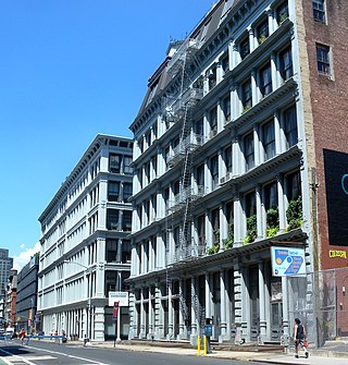
SoHo, sometimes written Soho, is a neighborhood in Lower Manhattan, New York City. Since the 1970s, the neighborhood has been the location of many artists' lofts and art galleries, and has also been known for its variety of shops ranging from trendy upscale boutiques to national and international chain store outlets. The area's history is an archetypal example of inner-city regeneration and gentrification, encompassing socioeconomic, cultural, political, and architectural developments.
Druid Hills is a community which includes both a census-designated place (CDP) in unincorporated DeKalb County, Georgia, United States, as well as a neighborhood of the city of Atlanta. The CDP's population was 14,568 at the 2010 census. The CDP formerly contained the main campus of Emory University and the Centers for Disease Control and Prevention (CDC) however they were annexed by Atlanta in 2018. The Atlanta-city section of Druid Hills is one of Atlanta's most affluent neighborhoods with a mean household income in excess of $238,500.

Pico-Union is a neighborhood in Central Los Angeles, California. The name "Pico-Union" refers to the neighborhood that surrounds the intersection of Pico Boulevard and Union Avenue. Located immediately west of Downtown Los Angeles, it is home to over 40,000 residents.

West Adams is a historic neighborhood in the South Los Angeles region of Los Angeles, California. The area is known for its large number of historic buildings, structures and notable houses and mansions.

West Ridge is one of 77 Chicago community areas. It is a middle-class neighborhood located on the far North Side of the City of Chicago. It is located in the 50th ward and the 40th ward. Also historically called North Town, and frequently referred to as West Rogers Park, it is bordered on the north by Howard Street, on the east by Ridge Boulevard, Western Avenue, and Ravenswood Avenue, the south by Bryn Mawr Avenue and Peterson Avenue, and on the west by Kedzie Avenue and the North Shore channel of the Chicago River. At one time joined with neighboring Rogers Park, it seceded to become its own village in 1890 over a conflict concerning park districts. West Ridge was annexed to Chicago on April 4, 1893, along with Rogers Park.

Chevy Chase is a neighborhood in northwest Washington, D.C. It borders Chevy Chase, Maryland, a collection of similarly affluent neighborhoods.

Woodbridge is a historic neighborhood of primarily Victorian homes located in Detroit, Michigan. The district was listed on the National Register of Historic Places in 1980, with later boundary increases in 1997 and 2008. In addition to its historic value, Woodbridge is also notable for being an intact neighborhood of turn-of-the-century homes within walking or biking distance of Detroit's Downtown, Midtown, New Center, and Corktown neighborhoods.
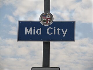
Mid City is a neighborhood in Central Los Angeles, California.

Vermont Square is a neighborhood in Los Angeles, California, within the South Los Angeles region. The Vermont Square Branch library, a designated Historic–Cultural Monument, is located in the community.
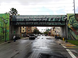
Overtown is a neighborhood of Miami, Florida, United States, just northwest of Downtown Miami. Originally called Colored Town in the Jim Crow era of the late 19th through the mid-20th century, the area was once the preeminent and is the historic center for commerce in the black community in Miami and South Florida.
The history of Tallahassee, Florida, much like the history of Leon County, dates back to the settlement of the Americas. Beginning in the 16th century, the region was colonized by Europeans, becoming part of Spanish Florida. In 1819, the Adams–Onís Treaty ceded Spanish Florida, including modern-day Tallahassee, to the United States. Tallahassee became a city and the state capital of Florida in 1821; the American takeover led to the settlements' rapid expansion as growing numbers of cotton plantations began to spring up nearby, increasing Tallahassees' population significantly.

Hawthorne is a neighborhood of 308 single family homes in the Northwest quadrant of Washington, D.C. According to neighborhood lore, the subdivision was named for the hawthorn trees once abundant in the area. The neighborhood borders Montgomery County, Maryland, and is bounded by Pinehurst Tributary to the south, Western Avenue to the northwest, and Rock Creek Park to the east.

Barnaby Woods is a neighborhood in the Northwest quadrant of Washington, D.C., wedged between Rock Creek Park and Montgomery County, Maryland. It is bounded on the north by Aberfoyle Place, on the west by Western Avenue, on the south by Tennyson Street, and on the east by Oregon Avenue. Barnaby Woods is entirely residential, with no commercial zoning whatsoever, and the housing consists primarily of 1930s colonial homes on large parcels of land although on Unicorn Lane NW there are only townhouses.

Capitol View is a historic in-town southwest Atlanta neighborhood 2.5 miles from downtown Atlanta, Georgia that was named for its view of the Georgia State Capitol building. Its boundaries include Metropolitan Parkway to the east, Lee Street to the west, and the Beltline to the north. On the south, the border follows Arden Street, Deckner Avenue, and Perkerson Park.

Barclay is a neighborhood in the center of Baltimore City. Its boundaries, as defined by the City Planning Office, are marked by North Avenue, Greenmount Avenue, Saint Paul and 25th Streets. The neighborhood lies north of Greenmount West, south of Charles Village, west of East Baltimore Midway, and east of Charles North and Old Goucher. The boundary between the Northern and Eastern police districts runs through the community, cutting it roughly in half.

Passyunk Square is a neighborhood in South Philadelphia bounded by Broad Street to the west, 6th Street to the east, Tasker Street to the south and Washington Avenue to the north. Passyunk Square is bordered by the Bella Vista, Hawthorne, Central South Philadelphia, Wharton, and Point Breeze neighborhoods. The neighborhood got its Lenape name from the 1800s Passyunk Township, Pennsylvania which named Passyunk Square Park, located between 12th, 13th, Reed and Wharton Streets. The park was eventually renamed Columbus Square Park, and subsequently the neighborhood became known as Columbus Square. Sue Montella, Geoff DiMasi, and a group of neighbors revived the Passyunk Square name when forming the Passyunk Square Civic Association in 2003. The name "Passyunk Square" was researched and proposed by Geoff DiMasi after considering other historical names like Wharton that had been used in the neighborhood over the years. The area has come to be known as Little Saigon for its large Vietnamese American commercial and residential presence, with one of the largest Vietnamese populations on the east coast.

West End is a neighborhood in Cincinnati, Ohio, United States, located northwest of downtown, east of Queensgate, west of Over-the-Rhine, and southeast of Fairview. The population was 6,824 at the 2020 Census.

Historic South Central Los Angeles is a 2.25-square-mile neighborhood in Los Angeles, California, within the South Los Angeles region. It is the site of the Bob Hope Patriotic Hall.
Lincoln High School, also known as Lincoln Academy, was a high school for African Americans in Tallahassee, Florida, United States. It is commonly referred to as "Historic Lincoln High School" or "Old Lincoln". There is no connection with Leon County's current Lincoln High School other than name.
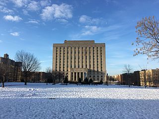
Concourse is a neighborhood in the southwestern section of the New York City borough of the Bronx which includes the Bronx County Courthouse, the Bronx Museum of the Arts, and Yankee Stadium. Its boundaries, starting from the north and moving clockwise, are East 169th Street to the north, Webster Avenue to the east, East 149th Street to the south, and Jerome Avenue and Harlem River to the west. The neighborhood is divided into three subsections: West Concourse, East Concourse, and Concourse Village with the Grand Concourse being its main thoroughfare.