
Lindisfarne, also called Holy Island, and the Holy Island of Lindisfarne, is a tidal island off the northeast coast of England, which constitutes the civil parish of Holy Island in Northumberland. Holy Island has a recorded history from the 6th century AD; it was an important centre of Celtic Christianity under Saints Aidan, Cuthbert, Eadfrith, and Eadberht of Lindisfarne. The island was originally home to a monastery, which was destroyed during the Viking invasions but re-established as a priory following the Norman Conquest of England. Other notable sites built on the island are St. Mary the Virgin parish church, Lindisfarne Castle, several lighthouses and other navigational markers, and a complex network of lime kilns. In the present day, the island is an Area of Outstanding Natural Beauty and a hotspot for historical tourism and bird watching. As of February 2020, the island had three pubs, a hotel and a post office.

Northumbria was an early medieval Anglo-Saxon kingdom in what is now Northern England and south-east Scotland.

Cuthbert of Lindisfarne was an Anglo-Saxon saint of the early Northumbrian church in the Celtic tradition. He was a monk, bishop and hermit, associated with the monasteries of Melrose and Lindisfarne in the Kingdom of Northumbria, today in north-eastern England and south-eastern Scotland. Both during his life and after his death, he became a popular medieval saint of Northern England, with a cult centred on his tomb at Durham Cathedral. Cuthbert is regarded as the patron saint of Northumbria. His feast days are 20 March and 4 September.
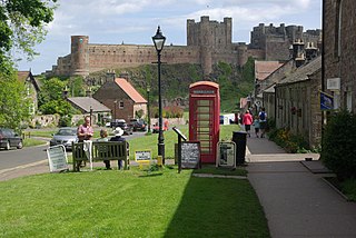
Bamburgh is a village and civil parish on the coast of Northumberland, England. It had a population of 454 in 2001, decreasing to 414 at the 2011 census.

The Lindisfarne Gospels is an illuminated manuscript gospel book probably produced around the years 715–720 in the monastery at Lindisfarne, off the coast of Northumberland, which is now in the British Library in London. The manuscript is one of the finest works in the unique style of Hiberno-Saxon or Insular art, combining Mediterranean, Anglo-Saxon and Celtic elements.
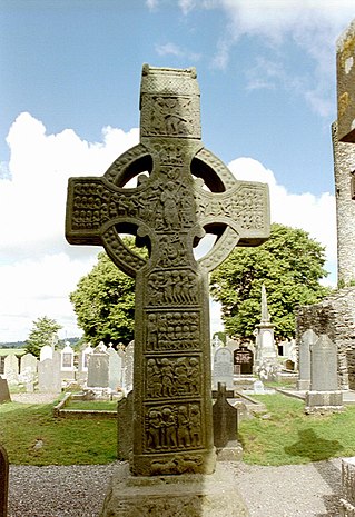
A high cross or standing cross is a free-standing Christian cross made of stone and often richly decorated. There was a unique Early Medieval tradition in Ireland and Britain of raising large sculpted stone crosses, usually outdoors. These probably developed from earlier traditions using wood, perhaps with metalwork attachments, and earlier pagan Celtic memorial stones; the Pictish stones of Scotland may also have influenced the form. The earliest surviving examples seem to come from the territory of the Anglo-Saxon kingdom of Northumbria, which had been converted to Christianity by Irish missionaries; it remains unclear whether the form first developed in Ireland or Britain.

Anglo-Saxon architecture was a period in the history of architecture in England from the mid-5th century until the Norman Conquest of 1066. Anglo-Saxon secular buildings in Britain were generally simple, constructed mainly using timber with thatch for roofing. No universally accepted example survives above ground. Generally preferring not to settle within the old Roman cities, the Anglo-Saxons built small towns near their centres of agriculture, at fords in rivers or sited to serve as ports. In each town, a main hall was in the centre, provided with a central hearth.

County Durham, officially simply Durham (/ˈdʌrəm/), is a ceremonial county in North East England. The county borders Northumberland and Tyne and Wear to the north, the North Sea to the east, North Yorkshire to the south, and Cumbria to the west. The largest settlement is Darlington, and the county town is the city of Durham.

Norton, also known as Norton-on-Tees, is a market town and civil parish in the Borough of Stockton-on-Tees, in County Durham, England. The suburbs of Roseworth and Ragworth are notable areas of the town. Billingham Beck is to the east of the town, the beck flows to the south-east. The town also contains the areas of Wolviston and Wynyard which are to the north of the town and are wards of the town. The town had a population of 20,829 in the 2011 Census.

Piercebridge is a village and civil parish in the borough of Darlington and the ceremonial county of Durham, England. The population of the civil parish as of the 2011 census was 113. It is situated a few miles west of the town of Darlington. It is on the site of a Roman fort of AD 260–270, which was built at the point where Dere Street crossed the River Tees. Part of the fort is under the village green. The village is sited where the York-Newstead Roman road known as Dere Street crosses the River Tees.

High Coniscliffe is a parish and village in the borough of Darlington and ceremonial county of County Durham, England. The parish includes Carlbury and Low Coniscliffe. It is part of Heighington and Coniscliffe ward, and is situated approximately 4 miles (6.4 km) west of Darlington. At the 2011 Census the population of this civil parish was 242.

Sockburn is a village and former civil parish, now in the parish of Neasham, in the Darlington district, in the ceremonial county of Durham, England. It is situated at the apex of a meander of the River Tees, to the south of Darlington, known locally as the Sockburn Peninsula. Today, all that remains of the village is an early nineteenth-century mansion, a ruined church and a farmhouse built in the late eighteenth century.

Anglo-Saxon art covers art produced within the Anglo-Saxon period of English history, beginning with the Migration period style that the Anglo-Saxons brought with them from the continent in the 5th century, and ending in 1066 with the Norman Conquest of England, whose sophisticated art was influential in much of northern Europe. The two periods of outstanding achievement were the 7th and 8th centuries, with the metalwork and jewellery from Sutton Hoo and a series of magnificent illuminated manuscripts, and the final period after about 950, when there was a revival of English culture after the end of the Viking invasions. By the time of the Conquest the move to the Romanesque style is nearly complete. The important artistic centres, in so far as these can be established, were concentrated in the extremities of England, in Northumbria, especially in the early period, and Wessex and Kent near the south coast.
Hartlepool Abbey, also known as Heretu Abbey, Hereteu Abbey, Heorthu Abbey or Herutey Abbey, was a Northumbrian monastery founded in 640 CE by Hieu, the first of the saintly recluses of Northumbria, and Aidan of Lindisfarne, on the Headland Estate of Hartlepool now called the Heugh or Old Hartlepool, in County Durham, England.

St Peter's Church is in the village of Heysham, Lancashire, England. It is recorded in the National Heritage List for England as a designated Grade I listed building. It is an active Anglican parish church in the deanery of Lancaster, the archdeaconry of Lancaster and the diocese of Blackburn.
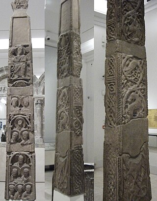
The Easby Cross is an Anglo-Saxon sandstone standing cross from 800–820, now in the Victoria and Albert Museum, London. It originally came from Easby near Richmond in the Richmondshire district of North Yorkshire, where a plaster replica is kept in the church. Easby was then in the Kingdom of Northumbria. The width of the long faces at the bottom of the lowest fragment is 31 cm (12 in), with a depth of 18 cm (7.1 in), and the whole cross would originally have been up to 3 metres (9.8 ft) high.

Tidfrith or Tidferth was an early 9th-century Northumbrian prelate. Said to have died on his way to Rome, he is the last known Anglo-Saxon bishop of Hexham. This bishopric, like the bishopric of Whithorn, probably ceased to exist, and was probably taken over by the authority of the bishopric of Lindisfarne. A runic inscription on a standing cross found in the cemetery of the church of Monkwearmouth is thought to bear his name.

The parish church of St Mary and St Cuthbert is a Church of England church in Chester-le-Street, County Durham, England. The site has been used for worship for over 1100 years; elements of the current building are over 950 years old. The oldest surviving translation of the Gospels into English was done here, by Aldred between 947 and 968, at a time when it served as the centre of Christianity from Lothian to Teesside.

The Wolverhampton Pillar is the shaft of an Anglo-Saxon High cross, dating from the ninth or tenth centuries AD.

Northumbria, in modern contexts, usually refers to the region of England between the Tees and Tweed, including the historic counties of Northumberland and Durham, but it may also be taken to be synonymous with North East England. The area corresponds to the rump lands of the historical Kingdom of Northumbria, which later developed into the late medieval county of Northumberland or Comitatus Northumbriae, whose original southern boundary was the River Tees. A provincial flag of Northumbria has been registered.
 Church of St Mary
 The Cross Keys Public House, Gainford
 Commemorative village cross
 A view of the village Green


