Galena, Indiana

Last updated

Galena, Indiana
Galena, Indiana.jpg
Floyd County Indiana Incorporated and Unincorporated areas Galena Highlighted 1826206.svg
Location of Galena in Floyd County, Indiana.
Coordinates: 38°21′2″N85°56′26″W / 38.35056°N 85.94056°W / 38.35056; -85.94056
Country United States
State Indiana
County Floyd
Area
[1]
  Total2.68 sq mi (6.94 km2)
  Land2.67 sq mi (6.92 km2)
  Water0.01 sq mi (0.02 km2)
Elevation
[2]
814 ft (248 m)
Population
 (2020)
  Total1,726
  Density646.20/sq mi (249.49/km2)
Time zone UTC-5 (Eastern (EST))
  Summer (DST) UTC-4 (EDT)
ZIP code
47119
Area code(s) 812 & 930
FIPS code 18-26206 [3]
GNIS feature ID0434921 [2]

Galena is a census-designated place (CDP) in Floyd County, Indiana, United States. The population was 1,818 at the 2010 census. The CDP includes the town of Galena as well as the nearby town of Floyds Knobs and their immediate surroundings.

Contents

History

Galena was originally called Germantown, and under the latter name was platted in 1837. [4] A post office was established as Galena in 1843, and remained in operation until it was discontinued in 1933. [5]

Geography

According to the United States Census Bureau, the CDP has a total area of 2.68 square miles (6.94 km2), of which 2.67 square miles (6.92 km2) is land and 0.01 square miles (0.03 km2) is water. [6]

Demographics

Historical population
CensusPop.Note
2020 1,726
U.S. Decennial Census [7]

2010 census

As of the census [8] of 2010, there were 1,818 people, 637 households, and 534 families residing in the CDP. The population density was 680.9 inhabitants per square mile (262.9/km2). There were 659 housing units at an average density of 246.8 per square mile (95.3/km2). The racial makeup of the CDP was 98.6% White, 0.2% Native American, 0.6% Asian, 0.1% from other races, and 0.6% from two or more races. Hispanic or Latino of any race were 0.7% of the population.

There were 637 households, of which 42.4% had children under the age of 18 living with them, 68.0% were married couples living together, 10.5% had a female householder with no husband present, 5.3% had a male householder with no wife present, and 16.2% were non-families. 12.9% of all households were made up of individuals, and 4.9% had someone living alone who was 65 years of age or older. The average household size was 2.85 and the average family size was 3.12.

The median age in the CDP was 38.2 years. 27% of residents were under the age of 18; 8.4% were between the ages of 18 and 24; 25.4% were from 25 to 44; 29.5% were from 45 to 64; and 9.8% were 65 years of age or older. The gender makeup of the CDP was 48.8% male and 51.2% female.

2000 census

As of the census [3] of 2000, there were 1,831 people, 622 households, and 539 families residing in the CDP. The population density was 691.2 inhabitants per square mile (266.9/km2). There were 638 housing units at an average density of 240.8 per square mile (93.0/km2). The racial makeup of the CDP was 97.87% White, 0.22% African American, 0.38% Native American, 0.66% Asian, 0.16% from other races, and 0.71% from two or more races. Hispanic or Latino of any race were 0.87% of the population.

There were 622 households, out of which 48.2% had children under the age of 18 living with them, 74.3% were married couples living together, 10.0% had a female householder with no husband present, and 13.3% were non-families. 10.9% of all households were made up of individuals, and 2.6% had someone living alone who was 65 years of age or older. The average household size was 2.94 and the average family size was 3.19.

In the CDP, the population was spread out, with 31.7% under the age of 18, 6.1% from 18 to 24, 34.7% from 25 to 44, 21.5% from 45 to 64, and 6.0% who were 65 years of age or older. The median age was 34 years. For every 100 females, there were 95.4 males. For every 100 females age 18 and over, there were 92.2 males.

The median income for a household in the CDP was $60,313, and the median income for a family was $67,569. Males had a median income of $47,455 versus $31,193 for females. The per capita income for the CDP was $23,824. About 3.3% of families and 2.9% of the population were below the poverty line, including 1.4% of those under age 18 and 4.1% of those age 65 or over.

Education

Galena is within the New Albany-Floyd County Consolidated School Corporation. [9]

The western half of Galena is in the attendance boundary of Greenville Elementary School, [10] while the eastern half is assigned to Floyds Knobs Elementary School. [11] All of Galena is within the attendance boundaries of Highland Hills Middle School, [12] and Floyd Central High School. [13]

Related Research Articles

<span class="mw-page-title-main">Desert Hills, Arizona</span> CDP in Mohave County, Arizona

Desert Hills is an unincorporated community and census-designated place (CDP) in Mohave County, Arizona, United States. The population was 2,764 at the 2020 census, up from 2,245 at the 2010 census.

<span class="mw-page-title-main">Sherwood Manor, Connecticut</span> Census-designated place in Connecticut, United States

Sherwood Manor is a census-designated place (CDP) within the town of Enfield in Hartford County, Connecticut, United States. The population was 5,410 at the 2010 census.

<span class="mw-page-title-main">Shannon, Georgia</span> Place in Georgia, United States

Shannon is an unincorporated community and census-designated place (CDP) in Floyd County, Georgia, United States. It is part of the Rome, Georgia Metropolitan Statistical Area. The population was 1,862 at the 2010 census.

<span class="mw-page-title-main">Georgetown, Floyd County, Indiana</span> Place in Indiana, United States

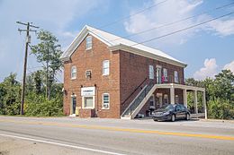
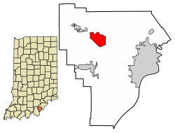
Georgetown is a town in Floyd County, Indiana, United States. The population was 3,805 at the 2020 census.

<span class="mw-page-title-main">Galena, Maryland</span> Town in Maryland, United States

Galena is a town in Kent County, Maryland, United States. The population was 612 at the 2010 census.

<span class="mw-page-title-main">Naschitti, New Mexico</span> CDP in New Mexico, United States

Naschitti is a census-designated place (CDP) in San Juan County, New Mexico, United States. The population was 360 at the 2000 census. It is part of the Farmington Metropolitan Statistical Area. The town was established in 1886, when Tom Bryan set up a trading post east of the Chuska Mountains. With a Navajo name, Naschitti means "badger springs."

<span class="mw-page-title-main">Newcomb, New Mexico</span> CDP in New Mexico, United States

Newcomb is a census-designated place (CDP) in San Juan County, New Mexico, United States. The population was 387 at the 2000 census. It is part of the Farmington Metropolitan Statistical Area.

<span class="mw-page-title-main">Jarales, New Mexico</span> CDP in New Mexico, United States

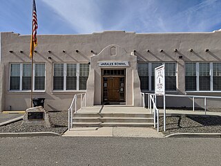
Jarales is a census-designated place (CDP) in Valencia County, New Mexico, United States. The population was 2,475 at the 2010 census. It is part of the Albuquerque Metropolitan Statistical Area.

<span class="mw-page-title-main">Beaverdale, Pennsylvania</span> Census-designated place in Pennsylvania, United States

Beaverdale is an unincorporated community and census-designated place (CDP) in Cambria County, Pennsylvania, United States. The population was 1,035 at the 2010 census. Prior to that time, the CDP was known as Beaverdale-Lloydell.

<span class="mw-page-title-main">Boothwyn, Pennsylvania</span> Census-designated place in Pennsylvania, United States

Boothwyn is a census-designated place (CDP) in Delaware County, Pennsylvania, United States. The population was 4,933 at the 2010 census, down from 5,206 at the 2000 census. The census estimation for population circa 2019 is 6,115.

<span class="mw-page-title-main">Cumings, Texas</span> Census-designated place in Texas, United States

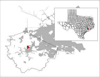
Cumings is an unincorporated community and census-designated place (CDP) in Fort Bend County, Texas, United States. The population was 981 at the 2010 census.

<span class="mw-page-title-main">San Carlos, Texas</span> Census-designated place in Texas

San Carlos is a community and census-designated place (CDP) in Hidalgo County, Texas. The population was 3,130 at the 2010 United States Census. It is part of the McAllen–Edinburg–Mission Metropolitan Statistical Area.

<span class="mw-page-title-main">El Refugio, Texas</span> CDP in Texas, United States

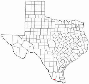
El Refugio is a census-designated place (CDP) in Starr County, Texas, United States. The population was 331 at the 2010 census. El Refugio gained area in the 2010 census.

<span class="mw-page-title-main">Bruni, Texas</span> CDP in Texas, United States

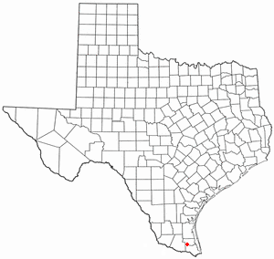
Bruni is a census-designated place (CDP) in Webb County, Texas, United States. The population was 379 at the 2010 census.

Bausell and Ellis is a former census-designated place (CDP) in Willacy County, Texas, United States. The population was 112 at the 2000 census.

<span class="mw-page-title-main">Sebastian, Texas</span> CDP in Texas, United States

Sebastian is a census-designated place (CDP) in Willacy County, Texas, United States. The population was 1,917 at the 2010 census.

<span class="mw-page-title-main">Zapata Ranch, Texas</span> CDP in Texas, United States

Zapata Ranch is a census-designated place (CDP) in Willacy County, Texas, United States. The population was 108 at the 2010 census.

<span class="mw-page-title-main">Albany, Wyoming</span> CDP in Wyoming, United States

Albany is a census-designated place (CDP) in Albany County, Wyoming, United States. The population was 55 at the 2010 census.

<span class="mw-page-title-main">The Buttes, Wyoming</span> Unincorporated community in Wyoming, United States

The Buttes is an unincorporated community in Albany County, Wyoming, United States. The population was 31 at the 2000 census, when it was a census-designated place (CDP).

<span class="mw-page-title-main">Shell Knob, Missouri</span> Census-designated place in Missouri, United States

Shell Knob is a census-designated place (CDP) located within White River Township, Barry County, Missouri. The population was 1,254 at the 2020 census.

References

  1. "2020 U.S. Gazetteer Files". United States Census Bureau. Retrieved March 16, 2022.
  2. 1 2 U.S. Geological Survey Geographic Names Information System: Galena, Indiana
  3. 1 2 "U.S. Census website". United States Census Bureau . Retrieved January 31, 2008.
  4. History of the Ohio Falls Cities and Their Counties: Precincts of Jefferson County, Ky. General histories of Clark and Floyd counties, Ind. New Albany and Floyd County. Clark County and Jeffersonville. L. A. Williams & Company. 1882. p.  298.
  5. "Floyd County". Jim Forte Postal History. Retrieved September 5, 2014.
  6. "US Gazetteer files 2010". United States Census Bureau. Archived from the original on July 2, 2012. Retrieved December 11, 2012.
  7. "Census of Population and Housing". Census.gov. Retrieved June 4, 2016.
  8. "U.S. Census website". United States Census Bureau . Retrieved December 11, 2012.
  9. "2010 CENSUS - CENSUS BLOCK MAP: Galena CDP, IN" (Archive). U.S. Census Bureau. Retrieved on April 9, 2015.
  10. "Greenville Redistrict" (Archive). New Albany-Floyd County Consolidated School Corporation. Retrieved on April 9, 2015.
  11. "Floyds Knobs Redistrict" (Archive). New Albany-Floyd County Consolidated School Corporation. Retrieved on April 9, 2015.
  12. Highland Hills Middle School District Map (Archive). New Albany-Floyd County Consolidated School Corporation. Retrieved on April 9, 2015.
  13. Floyd Central High School District Map (Archive). New Albany-Floyd County Consolidated School Corporation. Retrieved on April 9, 2015.