
Weener is a town in the district of Leer, in Lower Saxony, Germany. It is situated near the border with the Netherlands, on the river Ems. The towns population is at 15,654, making it the largest town of the region Rheiderland. It has a railway and autobahn connection to Groningen, Netherlands, Emden and Bremen.

Langenhagen is a town in the Hanover district of Lower Saxony, Germany.
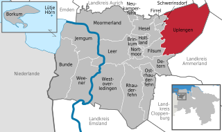
Uplengen is a municipality in the Leer district, in Lower Saxony, Germany.

Hatten is a municipality in Oldenburg, in Lower Saxony, Germany. It is situated 16 km (9.94 mi) southeast of Oldenburg, on the North-West edge of the Wildeshausen Geest Nature Park. Apart from the aesthetically and ecologically attractive countryside it exhibits, the municipality is modern and future-oriented. The cornerstone of the local economy is agriculture, with several other sectors playing an increasingly important role.

Eschede is a municipality in the district of Celle, in Lower Saxony, Germany. Situated approximately 15 km northeast of Celle, Eschede lies at the border of the Südheide Nature Park, a protected area of large forests and heaths. Today around 20 small villages are part of the "Gemeinde Eschede".

Boldecker Land is a municipality in the district of Gifhorn, in Lower Saxony, Germany. It is situated along the river Aller, approx. 12 km east of Gifhorn, and 8 km northwest of Wolfsburg. Its seat is in the village Weyhausen.

Hankensbüttel is a municipality in the Samtgemeinde Hankensbüttel in the district of Gifhorn, Lower Saxony, Germany. It is situated approximately 25 km south of Uelzen, and 30 km north of Gifhorn. The Municipality Hankensbüttel includes the villages of Alt Isenhagen, Emmen and Hankensbüttel,

Langelsheim is a town in the district of Goslar in Lower Saxony, Germany.

Liebenburg is a municipality in the district of Goslar, in Lower Saxony, Germany.

Neu Wulmstorf (help·info) is a municipality ('Einheitsgemeinde') in the district of Harburg, in Lower Saxony, Germany. It changed its name on December 11, 1964 from ″Wulmstorf″ to ″Neu Wulmstorf″. It is part of the Hamburg Metropolitan Region.

Seevetal is a municipality in the district of Harburg, in Lower Saxony, Germany. It is situated approximately 20 km south of Hamburg, and 15 km west of Winsen (Luhe). Its seat is in the village Hittfeld. It is named after the river Seeve.

Giesen is a village and a municipality in the district of Hildesheim, in Lower Saxony, Germany. It is situated approximately 6 km northwest of Hildesheim, and 22 km southeast of Hanover.

Lamspringe is a village and a municipality in the district of Hildesheim, in Lower Saxony, Germany. It is situated approximately 20 km south of Hildesheim. Since 1 November 2016, the former municipalities Harbarnsen, Neuhof, Sehlem and Woltershausen are part of the municipality Lamspringe.
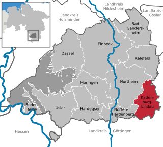
Katlenburg-Lindau is a municipality in the Landkreis (district) of Northeim in Lower Saxony, Germany. It is situated approximately 10 km southeast of Northeim, and 20 km northeast of Göttingen. Katlenburg-Lindau was formed on 1 March 1974 from the formerly independent communities of Katlenburg-Duhm, Gillersheim, Berka, Elvershausen, Wachenhausen, Suterode and Lindau. With the exception of Lindau, which had belonged Landkreis Duderstadt, these communities were part of Landkreis Northeim. The Max Planck Institute for Solar System Research of the Max Planck Society was located in Lindau from 1946 to 2014, when it was moved to Göttingen. Until June 2004 the MPI was known as "Max-Planck-Institut für Aeronomie".

Wallenhorst is a municipality in the district of Osnabrück, in Lower Saxony, Germany. It is situated in the Wiehengebirge, approx. 10 km north of Osnabrück.

Auetal is a municipality in the district of Schaumburg, in Lower Saxony, Germany. It is situated approximately 10 km south of Stadthagen, and 22 km east of Minden. Its seat is in the village Rehren.

Burgdorf is a town in the Hanover Region, in Lower Saxony, Germany. It is situated approximately 22 km northeast of Hanover. Until 1974, Burgdorf was the capital of the Burgdorf district. The town and its surrounding areas are known for the tradition of growing white Asparagus and for breeding Hanoverian horses. Burgdorf hosts a monthly horse market from April to September every year.

Wunstorf is a town in the district of Hanover, in Lower Saxony, Germany. It is situated approximately 22 km west of Hanover. The following localities belong to the town of Wunstorf: Blumenau, Bokeloh, Großenheidorn, Idensen, Klein Heidorn, Kolenfeld, Luthe, Mesmerode, Steinhude, and Wunstorf.
The Samtgemeinde Rodenberg is a collective municipality in Lower Saxony, Germany, of about 16,000 inhabitants. It is situated in the east of the district of Schaumburg at the slopes of the hills Deister and Süntel.

Schladen-Werla is a municipality in the district of Wolfenbüttel, in Lower Saxony, Germany. It was formed on 1 November 2013, when the municipalities of the former Samtgemeinde Schladen: Gielde, the town of Hornburg, Schladen proper, and Werlaburgdorf were merged.


