
Gannets are seabirds comprising the genus Morus, in the family Sulidae, closely related to boobies. "Gannet" is derived from Old English ganot, ultimately from the same Old Germanic root as "gander". Morus is derived from Ancient Greek moros, "foolish", due to the lack of fear shown by breeding gannets and boobies, allowing them to be easily killed.

The northern gannet is a seabird, the largest species of the gannet family, Sulidae. It is native to the coasts of the Atlantic Ocean, breeding in Western Europe, North America, and the Caribbean. The sexes are similar in appearance. The adult northern gannet has a mainly white streamlined body with a long neck, long and slender wings. It is 87–100 cm (34–39 in) long with a 170–180 cm (67–71 in) wingspan. The head and nape have a buff tinge that is more prominent in breeding season, and the wings are edged with dark brown-black feathers. The long pointed bill is blue-grey, contrasting with black bare skin around the mouth and eyes. Juveniles are mostly grey-brown, becoming increasingly white in the five years it takes them to reach maturity.

The Chattahoochee River forms the southern half of the Alabama and Georgia border, as well as a portion of the Florida - Georgia border. It is a tributary of the Apalachicola River, a relatively short river formed by the confluence of the Chattahoochee and Flint rivers and emptying from Florida into Apalachicola Bay in the Gulf of Mexico. The Chattahoochee River is about 430 miles (690 km) long. The Chattahoochee, Flint, and Apalachicola rivers together make up the Apalachicola–Chattahoochee–Flint River Basin. The Chattahoochee makes up the largest part of the ACF's drainage basin.

Lake Strom Thurmond, officially designated J. Strom Thurmond Reservoir at the federal level, and Clarks Hill Lake by the state of Georgia, is a reservoir at the border between Georgia and South Carolina in the Savannah River Basin.

The Etowah River is a 164-mile-long (264 km) waterway that rises northwest of Dahlonega, Georgia, north of Atlanta. On Matthew Carey's 1795 map the river was labeled "High Town River". On later maps, such as the 1839 Cass County map, it was referred to as "Hightower River", a name that was used in most early Cherokee records.

The Australasian gannet, also known as the Australian gannet or tākapu, is a large seabird of the booby and gannet family, Sulidae. Adults are mostly white, with black flight feathers at the wingtips and lining the trailing edge of the wing. The central tail feathers are also black. The head is tinged buff-yellow, with a pale blue-grey bill edged in black, and blue-rimmed eyes. Young birds have mottled plumage in their first year, dark above and light below. The head is an intermediate mottled grey, with a dark bill. The birds gradually acquire more white in subsequent seasons until they reach maturity after five years.

The Oconee River is a 220-mile-long (350 km) river in the U.S. state of Georgia. Its origin is in Hall County and it terminates where it joins the Ocmulgee River to form the Altamaha River near Lumber City at the borders of Montgomery County, Wheeler County, and Jeff Davis County. South of Athens, two forks, known as the Middle Oconee River and North Oconee River, which flow for 55–65 miles (89–105 km) upstream respectively before converging to form the Oconee River. Milledgeville, the former capital city of Georgia, lies on the Oconee River.

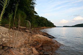
Lake Allatoona is a U.S. Army Corps of Engineers reservoir on the Etowah River in northwestern part of the State of Georgia. This reservoir is mostly in southeastern Bartow County and southwestern Cherokee County. A small portion is located in Cobb County near Acworth. Cartersville is the nearest city to Allatoona Dam. Also, Red Top Mountain State Park is located on its shores, on the peninsula between the two arms of the lake. Most of the north side of the lake remains protected from land development because of its isolated location, mostly blocked by the lake.

The Wiregrass Region—or Wiregrass Country—is an area of the Southern United States encompassing parts of southern Georgia, southeastern Alabama, and the Florida Panhandle. The region is named for the native Aristida stricta, commonly known as wiregrass due to its texture.
The Tugaloo River is a 45.9-mile-long (73.9 km) river bordering the U.S. states of Georgia and South Carolina. It was named for the Cherokee town of Tugaloo at the mouth of Toccoa Creek, near present-day Toccoa, Georgia and Travelers Rest in Stephens County, Georgia. It is fed by the Tallulah River and the Chattooga River, which each form an arm of Lake Tugalo, on the edge of Georgia's Tallulah Gorge State Park. The Tugaloo then flows out of the lake via Tugaloo Dam, passing into Lake Yonah and through Yonah Dam. The river then ends as an arm of Lake Hartwell, as does South Carolina's Seneca River. After flowing out of Lake Hartwell, it is called the Savannah River.

Lake Sinclair is a man-made lake in central Georgia near Milledgeville. It is operated by Georgia Power.
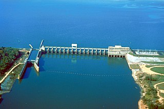
Lake Seminole is a reservoir located in the southwest corner of Georgia along its border with Florida, maintained by the U.S. Army Corps of Engineers. The Chattahoochee and Flint rivers join in the lake, before flowing from the Jim Woodruff Lock and Dam, which impounds the lake, as the Apalachicola River. The lake contains 37,500 acres (152 km2) of water, and has a shoreline of 376 mi (605 km). The fish in Lake Seminole include largemouth bass, crappie, chain pickerel, catfish, striped bass and other species. American alligators, snakes and various waterfowl are also present in the lake, which is known for its goose hunting.

USS Gannet (AM-41) was an Lapwing-class minesweeper built for the United States Navy near the end of World War I.

Lake Harding, also known as Bartlett's Ferry Lake, is a 5,850-acre (23.7 km2) reservoir on the Chattahoochee River.
Carters Lake, is a reservoir located on the Coosawattee River in the Blue Ridge Mountains in Gilmer and Murray counties in Georgia, United States, and is the state's deepest lake.
Tobesofkee Creek is a 58.9-mile-long (94.8 km) river in Georgia. It originates near Barnesville and flows roughly southeast across Lamar, Monroe, and Bibb counties to join the Ocmulgee River south of the city of Macon. A dam on this stream forms Lake Tobesofkee.

The order Suliformes is an order recognised by the International Ornithologist's Union. In regard to the recent evidence that the traditional Pelecaniformes is polyphyletic, it has been suggested that the group be split up to reflect the true evolutionary relationships.

Chemquasabamticook Lake is the source of Chemquasabamticook Stream in the North Maine Woods. The lake is in Maine townships 9 and 10 of range 15, and township 9 of range 14. Tributaries include Sweeney Brook, Boucher Brook, Gannet Brook, Fool Brook, and Ross Inlet. Chemquasabamticook Stream flows 22 miles (35 km) from a disused dam at the north end of the lake to reach Long Lake on the Allagash River. Chemquasabamticook Lake has a self-sustaining native squaretail population, and rainbow smelt have been introduced to encourage more rapid growth of the native togue.
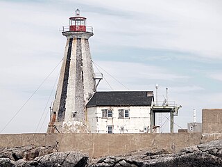
The Gannet Rock Lighthouse is a Canadian lighthouse located on a rocky islet 8 miles (13 km) south of Grand Manan in the Bay of Fundy. It was first lit in 1831 and was staffed until 1996. It was solarized in 2002 and remains operational in 2017. It was declared "surplus to requirements" by the Canadian Coast Guard in 2010 and is no longer being maintained.
