Garrison, Montana

Last updated
Garrison, Montana
CDP
Powell County Montana Incorporated and Unincorporated areas Garrison Highlighted.svg
Location of Garrison, Montana
Coordinates: 46°32′15″N112°49′35″W / 46.53750°N 112.82639°W / 46.53750; -112.82639 Coordinates: 46°32′15″N112°49′35″W / 46.53750°N 112.82639°W / 46.53750; -112.82639
Country United States
State Montana
County Powell
Area
[1]
  Total9.64 sq mi (24.96 km2)
  Land9.63 sq mi (24.95 km2)
  Water0.00 sq mi (0.01 km2)
Elevation
[2]
4,374 ft (1,333 m)
Population
 (2020)
  Total115
  Density11.94/sq mi (4.61/km2)
Time zone UTC-7 (Mountain (MST))
  Summer (DST) UTC-6 (MDT)
ZIP code
59731
Area code 406
FIPS code 30-30175
GNIS feature ID0771720 [2]

Garrison is a census-designated place (CDP) in Powell County, Montana, United States. The population was 112 at the 2000 census.

Contents

The traditional Salish name for the area that was later named Garrison Junction is snx̣ʷq̓pusaqs. Groups would split up here, with some going towards Helena, others towards Butte. [3]

History

A post office called Garrison was established in 1883, and remained in operation until 2015٫ [4] The community was named for William Lloyd Garrison, an abolitionist. [5] who was also the father-in-law of Henry Villard, the man who finally pushed the Northern Pacific Railroad to completion in 1883. [6] Garrison is just east of Gold Creek, where the 'golden spike' was driven on September 8, 1883 to mark the completion of the line. Among others present for the occasion was former President Ulysses S. Grant.

Geography

Garrison is located at 46°32′15″N112°49′35″W / 46.53750°N 112.82639°W / 46.53750; -112.82639 (46.537526, -112.826435). [7]

According to the United States Census Bureau, the CDP has a total area of 9.5 square miles (25 km2), all land.

Demographics

Historical population
CensusPop.
2020 115
U.S. Decennial Census [8]

As of the census [9] of 2000, there were 112 people, 50 households, and 34 families residing in the CDP. The population density was 11.7 people per square mile (4.5/km2). There were 63 housing units at an average density of 6.6 per square mile (2.5/km2). The racial makeup of the CDP was 91.96% White, 4.46% Native American, and 3.57% from two or more races. Hispanic or Latino of any race were 1.79% of the population.

There were 50 households, out of which 22.0% had children under the age of 18 living with them, 52.0% were married couples living together, 8.0% had a female householder with no husband present, and 32.0% were non-families. 24.0% of all households were made up of individuals, and 10.0% had someone living alone who was 65 years of age or older. The average household size was 2.24 and the average family size was 2.62.

In the CDP, the population was spread out, with 20.5% under the age of 18, 4.5% from 18 to 24, 23.2% from 25 to 44, 31.3% from 45 to 64, and 20.5% who were 65 years of age or older. The median age was 46 years. For every 100 females, there were 119.6 males. For every 100 females age 18 and over, there were 117.1 males.

The median income for a household in the CDP was $33,250, and the median income for a family was $32,656. Males had a median income of $16,250 versus $28,250 for females. The per capita income for the CDP was $12,678. There were 35.5% of families and 36.4% of the population living below the poverty line, including 90.0% of under eighteens and none of those over 64.

Related Research Articles

<span class="mw-page-title-main">Jefferson City, Montana</span> Census-designated place in Montana, United States

Jefferson City is an unincorporated community and census-designated place (CDP) in Jefferson County, Montana, United States. The population was 472 at the 2010 census. It is part of the Helena Micropolitan Statistical Area.

<span class="mw-page-title-main">Charlo, Montana</span> Census-designated place in Montana, United States

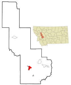
Charlo is an unincorporated community and census-designated place (CDP) in Lake County, Montana, United States. The population was 379 at the 2010 census, down from 439 in 2000. The 2018 population estimate was 320.

<span class="mw-page-title-main">Finley Point, Montana</span> Census-designated place in Montana, United States

Finley Point is a census-designated place (CDP) in Lake County, Montana, United States. As of the 2010 census the population was 480.

<span class="mw-page-title-main">Ravalli, Montana</span> Census-designated place in Montana, United States

Ravalli is an unincorporated community and census-designated place (CDP) in Lake County, Montana, United States. The population was 76 at the 2010 census, down from 119 in 2000. At one time Charlie Allard, the country's leading expert on breeding bison, owned the country's largest herd of buffalo in Ravalli.

<span class="mw-page-title-main">Turtle Lake, Montana</span> Census-designated place in Montana, United States

Turtle Lake is a census-designated place (CDP) in Lake County, Montana, United States. The population was 209 at the 2010 census.

<span class="mw-page-title-main">Helena Valley Northwest, Montana</span> CDP in Montana, United States

Helena Valley Northwest is a census-designated place (CDP) in Lewis and Clark County, Montana, United States. The population was 3,482 at the 2010 census. It is part of the Helena Micropolitan Statistical Area.

<span class="mw-page-title-main">Helena Valley West Central, Montana</span> Census-designated place in Montana, United States

Helena Valley West Central is a census-designated place (CDP) in Lewis and Clark County, Montana, United States. The population was 7,883 at the 2010 census. It is part of the Helena Micropolitan Statistical Area.

<span class="mw-page-title-main">Bonner-West Riverside, Montana</span> CDP in Montana, United States

Bonner-West Riverside is a census-designated place (CDP) in Missoula County, Montana, United States, including the unincorporated communities of Bonner, Milltown, West Riverside, and Pinegrove. It is part of the Missoula, Montana Metropolitan Statistical Area. The population was 1,663 at the 2010 census, a decline from its population of 1,693 in 2000.

<span class="mw-page-title-main">Clinton, Montana</span> CDP in Montana, United States

Clinton is a census-designated place (CDP) in Missoula County, Montana, United States. It is part of the 'Missoula, Montana Metropolitan Statistical Area'. The CDP was named for General Sir Henry Clinton. The population was 1,052 at the 2010 census, an increase from its population of 549 in 2000.

<span class="mw-page-title-main">Evaro, Montana</span> CDP in Montana, United States

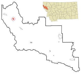
Evaro is a census-designated place (CDP) in Missoula County, Montana, United States, and part of the Missoula Metropolitan Statistical Area. It is located on the southernmost tip of the Flathead Indian Reservation, approximately 12 miles (19 km) north of downtown Missoula and is served by US Highway 93. In 2010, Evaro had a population of 322, a decrease from 329 in 2000.

<span class="mw-page-title-main">Elliston, Montana</span> CDP in Montana, United States

Elliston is a census-designated place (CDP) in Powell County, Montana, United States. The population was 225 at the 2000 census.

<span class="mw-page-title-main">Corvallis, Montana</span> Census-designated place in Montana, United States

Corvallis is a census-designated place (CDP) in Ravalli County, Montana, United States. The population was 1,125 at the 2020 census.

<span class="mw-page-title-main">Florence, Montana</span> Census-designated place in Montana, United States

Florence is a census-designated place (CDP) in Ravalli County, Montana, United States. The population was 821 at the 2020 census.

<span class="mw-page-title-main">Victor, Montana</span> Census-designated place in Montana, United States

Victor is a census-designated place (CDP) in Ravalli County, Montana, United States. The population was 745 at the 2010 census.

<span class="mw-page-title-main">Noxon, Montana</span> CDP in Montana, United States

Noxon is a census-designated place (CDP) in Sanders County, Montana, United States. The population of the whole CDP was 218 at the 2010 census.

<span class="mw-page-title-main">Paradise, Montana</span> CDP in Montana, United States

Paradise is a census-designated place (CDP) in Sanders County, Montana, United States. The population was 166 at the 2020 census.

<span class="mw-page-title-main">Greycliff, Montana</span> CDP in Montana, United States

Greycliff is a census-designated place (CDP) in Sweet Grass County, Montana, United States. The population was 56 at the 2000 census.

<span class="mw-page-title-main">Arlee, Montana</span> Census-designated place in Montana, United States

Arlee is an unincorporated community and census-designated place (CDP) in Lake County, Montana, United States. The population was 636 at the 2010 census. It is named after Alee, a Salish chief. The chief's name has no "r", as the Salish alphabet has no letter "r".

<span class="mw-page-title-main">Pablo, Montana</span> Census-designated place in Montana, United States

Pablo is a census-designated place (CDP) in Lake County, Montana, United States. The population was 2,254 at the 2010 census, up from 1,814 in 2000. It is the home of Salish Kootenai College and the seat of government of the Flathead Indian Reservation.

<span class="mw-page-title-main">Helena West Side, Montana</span> Census-designated place in Montana, United States

Helena West Side is a census-designated place (CDP) in Lewis and Clark County, Montana, United States. The population was 1,637 at the 2010 census, down from 1,711 at the 2000 census due to annexation of part of the CDP by the city of Helena. It is part of the Helena Micropolitan Statistical Area.

References

  1. "ArcGIS REST Services Directory". United States Census Bureau. Retrieved September 5, 2022.
  2. 1 2 U.S. Geological Survey Geographic Names Information System: Garrison, Montana
  3. Pete, Tachini. Seliš Nyoʻnuntn = Medicine for the Salish Language: English to Salish Translation Dictionary. 2nd ed. Pablo, MT : Lincoln, NE: Salish Kootenai College Press ; Distributed by University of Nebraska Press, 2010.
  4. "Powell County". Jim Forte Postal History. Retrieved 27 October 2015.
  5. Winser, Henry Jacob; Riley, William C. (1897). The Official Northern Pacific Railway Guide: For the Use of Tourists and Travelers Over the Lines of the Northern Pacific Railway and Its Branches. Northern Pacific Railway. p. 187.
  6. Gerdts, Alfred E. (1990). History of Garrison Montana. Alfred E. Gerdts. p. 3.
  7. "US Gazetteer files: 2010, 2000, and 1990". United States Census Bureau. 2011-02-12. Retrieved 2011-04-23.
  8. "Census of Population and Housing". Census.gov. Retrieved June 4, 2016.
  9. "U.S. Census website". United States Census Bureau . Retrieved 2008-01-31.