
Orange County, often known by its initials O.C., is a county located in the Los Angeles metropolitan area in Southern California, United States. As of the 2020 census, the population was 3,186,989, making it the third-most-populous county in California, the sixth-most-populous in the United States, and more populous than 19 American states and Washington, D.C. Although largely suburban, it is the second-most-densely-populated county in the state behind San Francisco County. The county's three most-populous cities are Anaheim, Santa Ana, and Irvine, each of which has a population exceeding 300,000. Santa Ana is also the county seat. Six cities in Orange County are on the Pacific coast: Seal Beach, Huntington Beach, Newport Beach, Laguna Beach, Dana Point, and San Clemente.
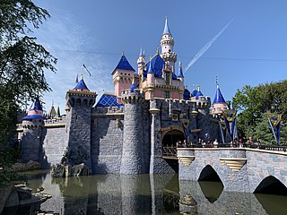
Anaheim is a city in northern Orange County, California, United States, part of the Los Angeles metropolitan area. As of the 2020 United States Census, the city had a population of 346,824, making it the most populous city in Orange County, the 10th-most populous city in California, and the 55th-most populous city in the United States. Anaheim is the second-largest city in Orange County in terms of land area, and is known for being the home of the Disneyland Resort, the Anaheim Convention Center, and two major sports teams: the Los Angeles Angels baseball team and the Anaheim Ducks ice hockey club.

Rancho Cucamonga was a 13,045-acre Mexican land grant in present-day San Bernardino County, California, given in 1839 to the dedicated soldier, smuggler and politician Tiburcio Tapia by Mexican governor Juan Bautista Alvarado. The grant formed parts of present-day California cities Rancho Cucamonga and Upland. It extended easterly from San Antonio Creek to what is now Hermosa Avenue, and from today's Eighth Street to the mountains.

West Adams is a historic neighborhood in the South Los Angeles region of Los Angeles, California. The area is known for its large number of historic buildings, structures and notable houses and mansions.

A California Historical Landmark (CHL) is a building, structure, site, or place in California that has been determined to have statewide historical landmark significance.
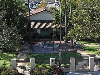
The Campo de Cahuenga, near the historic Cahuenga Pass in present-day Studio City, California, was an adobe ranch house on the Rancho Cahuenga where the Treaty of Cahuenga was signed between Lieutenant Colonel John C. Frémont and General Andrés Pico in 1847, ending hostilities in California between Mexico and the United States. The subsequent Treaty of Guadalupe Hidalgo of 1848, ceding California, parts of Colorado, Nevada, New Mexico, and Arizona to the United States, formally ended the Mexican–American War. From 1858 to 1861 the Campo de Cahuenga became a Butterfield Stage Station.

Fair Oaks Avenue in Pasadena, California, is a major north–south road connecting the communities of Altadena, Pasadena, and South Pasadena, running 7.9 miles (12.7 km) in length. It starts at its southernmost end in South Pasadena at Huntington Drive. It travels due north to a terminus above Loma Alta Avenue in Altadena and the gates of Angelus County Park. Beyond this, the road becomes a private easement.
Modjeska Canyon is an unincorporated community on the western slope of the Santa Ana Mountains in eastern Orange County, California. It is a suburban community of several hundred residents, with a small park and a volunteer fire station. The ZIP Code is 92676, and the community is inside area code 714.

Olinda is a neighborhood in Brea, California, located on Carbon Canyon Road east of the rest of the city. The original village was founded in the 1890s and grew when petroleum was discovered at the adjacent Brea-Olinda Oil Field. In February 1917, Olinda Village and the nearby town of Randolph were incorporated as the city of Brea. The site is now registered as California Historical Landmark #918 registered on January 1. 1978.
Downtown Anaheim, also known as Anaheim Colony Historic District, and as Anaheim Historic Center, is a neighborhood that serves as the administrative and historic center of the city of Anaheim, California. It is delimited by East, West, North, and South streets, and the main roads within it are Anaheim Boulevard, and Center Street.

Orange Grove Boulevard is a main thoroughfare in Pasadena and South Pasadena, California. Each New Year's Day, the Rose Parade participants and floats line up before dawn on Orange Grove Boulevard, facing north, for the beginning of the parade. South Orange Grove has been the address of the affluent, both the famous and the infamous, since the early 1900s. The Los Angeles Times said: "When a stranger comes to Pasadena now, the real-estate agent shows him Orange Grove Avenue.
John Frohling (1827–1862) was a key figure, along with Charles Kohler, in development of the Northern and Southern California wine industry and was the founder of Anaheim, California, in the mid 19th Century. He was also a member of the Los Angeles, California, Common Council, the governing body of that city.

The Woelke-Stoffel House is a two-story Queen Anne style home built in 1896, in Anaheim, Orange County, in Southern California. It was constructed by architects George Franklin Barber and Armstrong Davis Porter. The home is now owned by the City of Anaheim and part of Founders Park, in which sits a collection of historical buildings and acts as a museum. Free public tours are available on the 3rd Saturday of every month. Its location with close proximity to the Disneyland Resort makes it a popular tourist destination in the area. It was listed on the National Register of Historic Places on July 8, 2013. The house is in the Anaheim Founders' Park. Founders' Park also has the Pioneer House of the Mother Colony house built by the city's founder George Hanson. At the park is also a city landmark 1876 Moreton Bay Fig tree, a large Carriage House in Queen Anne style, vegetable garden, small orange grove, a Pump House and windmill.
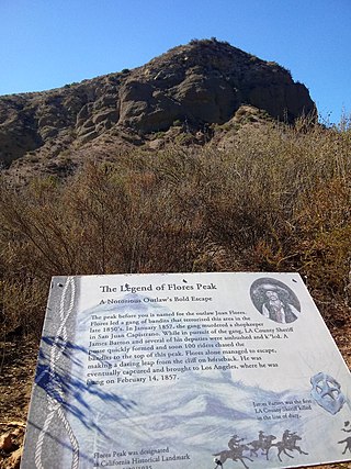
Flores Peak is a mountain peak, overlooking the confluence Harding Canyon and Modjeska Canyon, within the Tucker Wildlife Sanctuary in Orange County, California. It rises to an elevation of 1,834 feet. It is named for Juan Flores of the Flores Daniel Gang.

The Western Hotel is a hotel built in 1888 by the Gilroy family. It is the oldest surviving building in Lancaster, California. The Western Hotel was designated a California Historic Landmark (No.658) on September 26, 1958. The Western Hotel is located at 557 West Lancaster Boulevard, Lancaster, California, in Los Angeles County. George T. Webber purchased the Hotel and ran it as the Western Hotel. The hotel was built on a train stop that was built in 1876 by the Southern Pacific railroad. The line ran through the Antelope Valley, linking San Francisco to Los Angeles. The Hotel's large dining room became the meeting spot for the city. In the dining room: The Lancaster Chamber of Commerce was started, church socials held, quilting bees meetings, card parties, civic club meetings, and many Lancaster business meetings. While the Los Angeles-Owens River Aqueduct was being built, many of the construction crews were housed in the Hotel from 1905 to 1913. The Western Hotel in 1992 was remodeled to a small museum and offers free tours.

The Parent Washington Navel Orange Tree is a tree grown by Eliza Tibbets in Riverside, California, in 1873. The Riverside County tree was designated a California Historic Landmark (No.20) on June 1, 1932, at the corner of Magnolia Street and Arlington Street, Riverside. The Bahia, Brazil, Washington navel orange was brought to the United States by the U.S. Department of Agriculture in 1870. The Department of Agriculture imported twelve trees; from these trees, some buds were grafted on to California sweet orange trees. The Washington Navel Orange is also called California Navel Orange.

The Corona Founders Monument is a monument built in 1936 to the founding fathers of the City of Corona in the Riverside County, California. The monument was designated a California Historic Landmark (No.738) on June 6, 1960. The monument is in the Corona City Park in the 100 block of 6th Street of Corona, California. The founding fathers at first called the city South Riverside after the company they started the South Riverside Land and Water Company.

Tapia Adobe was the home of Tiburcio Tapia (1789–1845). Tiburcio Tapia was a Mexican soldier, politician, then became a merchant, winery owner and ranch owner, in what is now Cucamonga, California. The place of Tapia Adobe (home) was designated a California Historic Landmark (No.360) on October 9, 1939. Tiburcio Tapía received the land to build his Adobe and Rancho Cucamonga from a 1839 13,045-acre (52.79 km2) Mexican land grant in present-day San Bernardino County, California The land grant was from Mexican governor Juan Bautista Alvarado. The grant formed parts of present-day Rancho Cucamonga and Upland. It extended easterly from San Antonio Creek to what is now Hermosa Avenue, and from today's Eighth Street to the mountains.

The Mormon Trail Monument was designated a California Historic Landmark (No.577). The Monument is to remember the 500 Mormon pioneers came to the San Bernardino Valley in June 1851. The Monument is near Phelan, California in San Bernardino County, California. The Monument was built in 1937 and is on California State Route 138, 3.6 Miles West of Interstate 15. In 1857 about half the Mormons were told to return to Utah during the Mormon War, also call the Utah War. the Mormon War, or the Mormon Rebellion

The Old Maizeland School also called the Rivera School was designated a California Historic Landmark (No.729) on April 8, 1960. The Old Maizeland School was built in 1868 in what is today Pico Rivera, California, by James C. Shugg. James C. Shugg had five children: Alydia Caroline Shugg Gooch (1854–1938), Joannah Shugg Story (1857–1938), Thomas Shugg (1859–1902), Martha Jane Shugg Allison(1862–1946) and William E. Shugg (1863–1929). James C. Shugg and his wife, Esther Caroline Graham Shugg (1835–1908), wanted each child to have a good education and built the school on his land. For 27 years it served as the School house in what was called the Rivera District, at 8910 East Shugg Lane, now called Slauson Avenue. The pioneers used the Rivera School District school house to teach their children. In 1896, being too small for teaching now, it was sold, moved to a nearby farm of Ablbert McDonald and use as storage shed. In 1950 the School house was seen as Historical building and move to the Rivera School District Grounds and restored to be a School museum. The museum idea did not work and a year later the school was put up for sale.


