
Northamptonshire is a ceremonial county in the East Midlands of England. It is bordered by Leicestershire, Rutland, and Lincolnshire to the north, Cambridgeshire to the east, Bedfordshire, Buckinghamshire, Oxfordshire to the south, and Warwickshire to the west. Northampton is the largest settlement and the county town.

Corby is a town and civil parish in the North Northamptonshire unitary authority area of Northamptonshire, England. It is located 23 miles (37 km) north-east of Northampton. From 1974 to 2021, the town served as the administrative headquarters of the Borough of Corby. At the 2011 Census, the built-up area had a population of 56,810, while the borough, which was abolished in 2021, had a population of 75,571 in 2021.

Kettering is a market and industrial town in the North Northamptonshire unitary authority area of Northamptonshire, England. It forms a civil parish called Kettering Town. Kettering is located 67 miles (108 km) north of London and 15 miles (24 km) north-east of Northampton, west of the River Ise, a tributary of the River Nene. The name means "the place of Ketter's people ".
Ravensthorpe is a village and civil parish in West Northamptonshire in England. The village lies approximately midway between Northampton and Rugby. The M1 motorway is six miles west and the nearest railway station is at Long Buckby. At the time of the 2001 census, the parish's population was 656 people, including Coton but falling slightly to 646 at the 2011 census.
Overstone is a village and civil parish in West Northamptonshire, England. At the time of the 2001 census, the parish's population was 650 people, increasing to 741 at the 2011 Census.

Charwelton is a village and civil parish about 5 miles (8 km) south of Daventry in Northamptonshire, England. The 2011 Census recorded the parish's population as 220.

Chapel Brampton is a village and former civil parish now in the parish of Church with Chapel Brampton, in the West Northamptonshire district, in the ceremonial county of Northamptonshire, England. Together with nearby Church Brampton, it is known as The Bramptons. At the time of the 2001 census, Chapel Brampton parish's population was 470 people. On 1 April 2009 the parish was abolished and merged with Church Brampton to form "Church with Chapel Brampton".

Brigstock is a village and civil parish in the English county of Northamptonshire. Administratively it is part of North Northamptonshire. From 2001 to 2011, the parish population increased from 1,329 to 1,357.

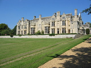
Apethorpe is a village, civil parish, former manor and ecclesiastical parish in Northamptonshire, England, situated 11 miles west of the City of Peterborough. The 2001 census records a population of 130, increasing to 160 at the 2011 census. The manor of Apethorpe is recorded in the Domesday Book of 1086 as Patorp. The village is compact, uniform and centred on Main Street. In the late 15th century the manor of Apethorpe was acquired by Sir Guy Wolston, an officer in the household of King Edward IV, who began the construction of the surviving Apethorpe Palace.
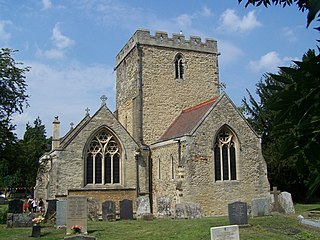
Barton Seagrave is a large village and civil parish in the North Northamptonshire, England. The village is about 1.5 miles (2.4 km) south-east of Kettering, town centre. The older part of the village is known for its Norman Church and attractive buildings.
Weekley is a small village and civil parish in the English county of Northamptonshire, on the outskirts of Kettering.

Warkton is a small nucleated village and civil parish in the English county of Northamptonshire. It is approximately three miles northeast of the town of Kettering and seven miles west-northwest of Thrapston, and forms part of North Northamptonshire. At the time of the 2001 census, the parish's population was 144 people, reducing slightly to 136 at the 2011 Census.
Thorpe Malsor is a village and civil parish 2 miles (3 km) west of Kettering, Northamptonshire, England. The population at the 2011 Census was 145.

Great Oakley is an outer suburb of Corby, in the civil parish of Corby Town, in the North Northamptonshire district, in the ceremonial county of Northamptonshire, England. It is situated approximately two miles south west of the town centre and five miles from Kettering. It was represented on Corby Borough Council by one councillor. The population of the Great Oakley Ward of Corby Borough Council at the 2011 Census was 2,248.

North Northamptonshire is one of two local government districts in Northamptonshire, England. It is a unitary authority area forming about one half of the ceremonial county of Northamptonshire. It was created in 2021. Its council is based in Corby, the district's largest town. Other notable towns are Kettering, Wellingborough, Rushden, Raunds, Desborough, Rothwell, Irthlingborough, Thrapston and Oundle.

East Carlton is a village and civil parish in the county of Northamptonshire, on the southern ridge overlooking the Welland valley to the north and covers 1,645 acres (666 ha) on a long strip of land. It is 2 miles (3.2 km) west of the town of Corby and is administered as part of North Northamptonshire but was previously in the Corby borough until 2021. At the time of the 2001 census, the parish's population was 270, reducing to 259 at the 2011 census. East Carlton is one of the Thankful Villages that suffered no fatalities during World War I. Although in Northamptonshire, the village is in the Leicestershire LE16 postcode area.
Rushton is a village and civil parish in Northamptonshire. It is about 2 miles (3.2 km) north-east of Rothwell and 3 miles (4.8 km) north-west of Kettering. The parish covers 3,200 acres (1,300 ha) and is situated on both sides of the River Ise. It contains the sites of three deserted settlements, details of which are set out below.

Loddington is a village and civil parish about 3 miles (5 km) west of Kettering, Northamptonshire, England.

