General William J. Fox Airfield

Last updated
General Wm. J. Fox Airfield
Kluft-photo-Lancaster-Fox-Field-Feb-2008-Img 0428.jpg
Fox Field (February 2008)
Summary
Airport typePublic
Owner County of Los Angeles
Serves Lancaster, California
Elevation  AMSL 2,351 ft / 717 m
Coordinates 34°44′28″N118°13′07″W / 34.74111°N 118.21861°W / 34.74111; -118.21861
Map
USA California location map.svg
Airplane silhouette.svg
WJF
Location of airport in California
Runways
Direction LengthSurface
ftm
6/247,2012,195Asphalt
Statistics (2011)
Aircraft operations81,851
Based aircraft157

General William J. Fox Airfield( IATA : WJF, ICAO : KWJF, FAA LID : WJF) is a county-owned, public airport in Los Angeles County, California, [1] five miles northwest of Lancaster, California, United States. [1] Locally known as Fox Field, the airport serves the Antelope Valley. The airport is named after Brigadier General William J. Fox, "a Marine war hero, a movie stunt man, the first Los Angeles County engineer and, for 20 years after his retirement, a cowboy." [2]

Contents

The National Plan of Integrated Airport Systems for 2011–2015 categorized it as a general aviation facility. [3] The airport has limited scheduled cargo operations. The U.S. Forest Service has a fixed wing airtanker and helicopter base on the airfield which becomes one of the main hubs in the region for aerial firefighting suppression efforts during fire season.

Historical airline service

Fox Field had scheduled passenger air service as early as the late 1950s operated by Southwest Airways with Douglas DC-3 aircraft primarily to the Los Angeles International Airport (LAX). [4] Southwest Airways then changed its name to Pacific Air Lines which in 1959 was operating new Fairchild F-27 turboprops from the airport nonstop to Las Vegas and also to Burbank Airport (BUR, now Hollywood Burbank Airport) on a daily basis as well as operating Martin 4-0-4 and DC-3 prop aircraft on flights to LAX. [5] By 1960, Pacific was operating daily F-27 propjet flights to San Francisco (SFO) from Fox Field via a stop in Bakersfield and also nonstop to LAX. [6] In 1968, Pacific Air Lines merged with Bonanza Air Lines and West Coast Airlines to form Air West which in turn continued to serve the airport with F-27 flights to LAX. [7] Also in 1968, Cable Commuter Airlines was operating de Havilland Canada DHC-6 Twin Otter service to LAX. [8] Air West then changed its name to Hughes Airwest which continued to operate scheduled passenger service with the Fairchild F-27 turboprop primarily to Los Angeles International Airport during the early 1970s with several nonstop flights a day. [9] By 1983, Mojave Airlines was operating flights to LAX, San Diego, Ontario and Mammoth Yosemite Airport with Beechcraft C99 turboprops. [10] In 1985, commuter air carrier Desert Sun Airlines was operating up to five flights a day nonstop to LAX with Beechcraft 99 turboprops. [11]

Fox Field currently does not have any scheduled passenger flights, with the nearest airline service being available at the Bob Hope Airport in Burbank.

Facilities

General William J. Fox Airfield covers 1,217 acres (493 ha) at an elevation of 2,351 feet (717 m) above sea level. Its one runway, 6/24, is 7,201 by 150 feet (2,195 x 46 m) asphalt. [1]

In the year ending August 10, 2011, the airport had 81,851 aircraft operations, average 224 per day: 97% general aviation, 2% air taxi, and 1% military. 157 aircraft were then based at this airport: 89% single-engine, 8% multi-engine, 2% helicopter, and 1% jet. [1]

Airlines and destinations

Cargo

AirlinesDestinations
Ameriflight Ontario

Related Research Articles

<span class="mw-page-title-main">William P. Hobby Airport</span> Municipal airport serving Houston, Texas, United States

William P. Hobby Airport is an international airport in Houston, Texas, located 7 miles (11 km) from downtown Houston. Hobby is Houston's oldest commercial airport, and was its primary airport until the Houston Intercontinental Airport, now known as the George Bush Intercontinental Airport, opened in 1969. Hobby was initially closed after the opening of Houston Intercontinental; however, it was re-opened after several years, and became a secondary airport for domestic airline service, and a center for corporate and private aviation.

<span class="mw-page-title-main">Oxnard Airport</span> General aviation airport in Oxnard, California

Oxnard Airport is a county-owned, public airport a mile west of downtown Oxnard, in Ventura County, California. The airport has not had scheduled passenger service since June 8, 2010, when United Express ended flights to Los Angeles International Airport. America West Express also served the airport with nonstop flights to Phoenix in the early-2000s via a code sharing agreement with America West Airlines.

<span class="mw-page-title-main">Eugene Airport</span> Airport in near Eugene, Oregon

Eugene Airport, also known as Mahlon Sweet Field, is a public airport 7 miles (11 km) northwest of Eugene, in Lane County, Oregon, United States. Owned and operated by the City of Eugene, it is the fifth-largest airport in the Pacific Northwest.

Panama City–Bay County International Airport(IATA: PFN, ICAO: KPFN, FAA LID: PFN) was a public airport 3 miles (4.8 km) northwest of Panama City, in Bay County, Florida. It was owned and operated by the Panama City–Bay County Airport and Industrial District. All airline services moved to the Northwest Florida Beaches International Airport on May 22, 2010, but the airfield was open to general aviation aircraft until October 1, 2010. The grounds will eventually be turned over to LUK-MB1 LLC, which plans to remove the runways and build homes, shops, walking trails and a marina.

<span class="mw-page-title-main">Faa'a International Airport</span> Main airport of French Polynesia

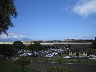
Faa'a International Airport, also known as Tahiti International Airport, is the international airport of French Polynesia, located in the commune of Faaa, on the island of Tahiti. It is situated 5 km (3.1 mi) southwest of Papeete, the capital city of the overseas collectivity. It opened in 1960. Regional air carrier Air Tahiti and international air carrier Air Tahiti Nui are both based at the airport.

<span class="mw-page-title-main">Palmdale Regional Airport</span> Joint public-military airport in Palmdale, California

Palmdale Regional Airport is an airport in Palmdale, California, United States. The city of Palmdale took over the airport at the end of 2013, managing it via the Palmdale Airport Authority. The airport currently does not have any scheduled passenger airline service.

<span class="mw-page-title-main">Tyler Pounds Regional Airport</span> Airport

Tyler Pounds Regional Airport is a city-owned, public-use airport located 3 mi (4.8 km) west of Tyler, in Smith County, Texas, United States.

<span class="mw-page-title-main">Inyokern Airport</span> Airport

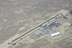
Inyokern Airport is a public use airport located 1 nautical mile northwest of the central business district of Inyokern, in Kern County, California, United States. It is owned by the Indian Wells Valley Airport District and serves the Indian Wells Valley area. The airport is mostly used for general aviation and was previously served by a number of commuter and regional airlines over the years with passenger flights to Los Angeles (LAX).

<span class="mw-page-title-main">Arcata–Eureka Airport</span> Regional airport in Humboldt County, California

California Redwood Coast – Humboldt County Airport, also known as Arcata–Eureka Airport and Arcata Airport, is in Humboldt County, California, United States, 8 miles (13 km) north of Arcata and 15 miles (24 km) north of Eureka, in McKinleyville.

<span class="mw-page-title-main">Imperial County Airport</span> Municipal airport in Imperial, California, United States

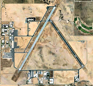
Imperial County Airport is a county-owned public-use airport in Imperial County, California, United States. Also known as Boley Field, it is mostly used for general aviation, but has scheduled passenger service from one commercial airline. Service is subsidized by the Essential Air Service program.

<span class="mw-page-title-main">Redding Regional Airport</span> Municipal airport serving the city of Redding in Shasta County, California, United States

Redding Regional Airport is 6 miles (10 km) southeast of Redding in Shasta County, California, United States. It is one of two airports in Redding, along with Benton Airpark. In addition to general aviation, the airport has scheduled passenger flights nonstop to and from Burbank (BUR) on Avelo Airlines Boeing 737s, Los Angeles (LAX) and San Francisco (SFO) on United Express Canadair CRJ200, CRJ700 and Embraer 175 regional jets, and Alaska Airlines Embraer 175 service to Seattle (SEA).

<span class="mw-page-title-main">Santa Maria Public Airport</span> Municipal airport in Santa Maria, California, United States

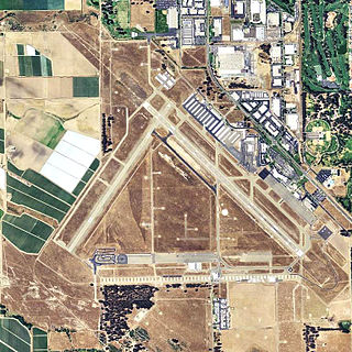
Santa Maria Public Airport is three miles (5 km) south of Santa Maria, in northern Santa Barbara County, California, United States.

<span class="mw-page-title-main">Magic Valley Regional Airport</span> Airport

Magic Valley Regional Airport, also known as Joslin Field, is a public use airport located four nautical miles (7 km) south of the central business district of Twin Falls, Idaho. The airport is owned by the City and County of Twin Falls. It is mostly used for general aviation but is also served by two commercial airlines.

Memorial Field Airport is located in City of Hot Springs, in Garland County, Arkansas, United States, 3 miles (4.8 km) southwest of Downtown Hot Springs. It serves nearby Hot Springs National Park. The airport is used for general aviation; airline flights are subsidized by the federal government's Essential Air Service program at a cost of $1,637,012.

<span class="mw-page-title-main">Juneau International Airport</span> International airport serving Juneau, Alaska, United States

Juneau International Airport is a city-owned, public-use airport and seaplane base located seven nautical miles northwest of the central business district of Juneau, a city and borough in the U.S. state of Alaska that has no direct road access to the outside world. The airport serves as a regional hub for all air travel, from bush carriers to major U.S. air carriers such as Alaska Airlines.

<span class="mw-page-title-main">Grand Canyon National Park Airport</span> Airport in Coconino County, Arizona

Grand Canyon National Park Airport is a state-owned public-use airport located in Tusayan, CDP in unincorporated Coconino County, Arizona, United States. It is near Grand Canyon National Park, 1 mile from the South Rim enterance of the Grand Canyon. The airport is primarily used for scenic tours and charter flights.

<span class="mw-page-title-main">Brownsville/South Padre Island International Airport</span> Airport in Brownsville, Texas, United States

Brownsville/South Padre Island International Airport is 5 miles east of downtown Brownsville, Cameron County, Texas.

<span class="mw-page-title-main">Eastern Sierra Regional Airport</span> Airport in the United States

Eastern Sierra Regional Airport is two miles east of Bishop, in Inyo County, California, United States. It is owned by the City of Los Angeles, Department of Public Works and operated by Inyo County.

<span class="mw-page-title-main">Mammoth Yosemite Airport</span> Regional airport in Mono County, California

Mammoth Yosemite Airport is a town-owned public airport seven miles east of Mammoth Lakes, in Mono County, California, United States. Also known as Mammoth Lakes Airport or Mammoth–June Lake Airport, it is mainly used for general aviation, but has scheduled passenger flights operated by one airline which primarily serves the airport on a seasonal basis during the winter ski season. Additional scheduled passenger service for the Mammoth area is seasonally available at the nearby Eastern Sierra Regional Airport located in Bishop, CA.

<span class="mw-page-title-main">Paso Robles Municipal Airport</span> Airport in San Luis Obispo County, California, United States

Paso Robles Municipal Airport is four miles (6.4 km) northeast of downtown Paso Robles, in San Luis Obispo County, California, United States.

References

  1. 1 2 3 4 5 FAA Airport Form 5010 for WJF PDF . Federal Aviation Administration. Effective November 15, 2012.
  2. "William J. Fox, 95, a War Hero, Engineer, Stunt Man and Cowboy". obituary. New York Times. April 17, 1993. Retrieved March 19, 2021.
  3. "2011–2015 NPIAS Report, Appendix A" (PDF). National Plan of Integrated Airport Systems. Federal Aviation Administration. October 4, 2010. Archived from the original (PDF, 2.03 MB) on 2012-09-27.
  4. http://www.timetableimages.com, April 28, 1957 Southwest Airways system timetable
  5. http://www.timertableimages.com, July 1, 1959 Pacific Air Lines system timetable
  6. http://www.timetableimages.com, April 24, 1960 Pacific Air Lines system timetable
  7. http://www.timetableimages.com, July 1, 1968 Air West system timetable
  8. http://www.timetableimages.com, Dec. 1, 1968 Cable Commuter Airlines system timetable
  9. http://www.departedflights.com, July 1, 1972 Hughes Airwest system timetable
  10. http://www.timetableimages.com, 1983 Mojave Airlines timetable
  11. http://www.departedflights.com, Feb. 15, 1985 Official Airline Guide (OAG), LAX schedules