
The geographic coordinate system (GCS) is a spherical or geodetic coordinate system for measuring and communicating positions directly on the Earth as latitude and longitude. It is the simplest, oldest and most widely used of the various spatial reference systems that are in use, and forms the basis for most others. Although latitude and longitude form a coordinate tuple like a cartesian coordinate system, the geographic coordinate system is not cartesian because the measurements are angles and are not on a planar surface.
A waypoint is an intermediate point or place on a route or line of travel, a stopping point or point at which course is changed, the first use of the term tracing to 1880. In modern terms, it most often refers to coordinates which specify one's position on the globe at the end of each "leg" (stage) of an air flight or sea passage, the generation and checking of which are generally done computationally.
vCard, also known as VCF, is a file format standard for electronic business cards. vCards can be attached to e-mail messages, sent via Multimedia Messaging Service (MMS), on the World Wide Web, instant messaging, NFC or through QR code. They can contain name and address information, phone numbers, e-mail addresses, URLs, logos, photographs, and audio clips.
GPX, or GPS Exchange Format, is an XML schema designed as a common GPS data format for software applications. It can be used to describe waypoints, tracks, and routes. It is an open format and can be used without the need to pay license fees. Location data is stored in tags and can be interchanged between GPS devices and software. Common software applications for the data include viewing tracks projected onto various map sources, annotating maps, and geotagging photographs based on the time they were taken.
ISO 6709, Standard representation of geographic point location by coordinates, is the international standard for representation of latitude, longitude and altitude for geographic point locations.

ICBMaddress or missile address is hacker slang for one's longitude and latitude when placed in a signature or another publicly available file.
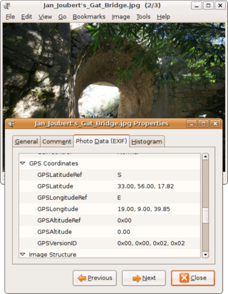
Geotagging, or GeoTagging, is the process of adding geographical identification metadata to various media such as a geotagged photograph or video, websites, SMS messages, QR Codes or RSS feeds and is a form of geospatial metadata. This data usually consists of latitude and longitude coordinates, though they can also include altitude, bearing, distance, accuracy data, and place names, and perhaps a time stamp.
In the Domain Name System, a LOC record is a means for expressing geographic location information for a domain name.
Keyhole Markup Language (KML) is an XML notation for expressing geographic annotation and visualization within two-dimensional maps and three-dimensional Earth browsers. KML was developed for use with Google Earth, which was originally named Keyhole Earth Viewer. It was created by Keyhole, Inc, which was acquired by Google in 2004. KML became an international standard of the Open Geospatial Consortium in 2008. Google Earth was the first program able to view and graphically edit KML files, but other projects such as Marble have added KML support.
Microformats (μF) are a set of defined HTML classes created to serve as consistent and descriptive metadata about an element, designating it as representing a certain type of data. They allow software to process the information reliably by having set classes refer to a specific type of data rather than being arbitrary. Microformats emerged around 2005 and were predominantly designed for use by search engines, web syndication and aggregators such as RSS.
hCalendar is a microformat standard for displaying a semantic (X)HTML representation of iCalendar-format calendar information about an event, on web pages, using HTML classes and rel attributes.
hCard is a microformat for publishing the contact details of people, companies, organizations, and places, in HTML, Atom, RSS, or arbitrary XML. The hCard microformat does this using a 1:1 representation of vCard properties and values, identified using HTML classes and rel attributes.
RDFa or Resource Description Framework in Attributes is a W3C Recommendation that adds a set of attribute-level extensions to HTML, XHTML and various XML-based document types for embedding rich metadata within Web documents. The Resource Description Framework (RDF) data-model mapping enables its use for embedding RDF subject-predicate-object expressions within XHTML documents. It also enables the extraction of RDF model triples by compliant user agents.
Operator was an extension for the Mozilla Firefox web browser. It parses and acts upon a number of microformats, as well as validating them.
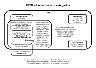
Semantic HTML is the use of HTML markup to reinforce the semantics, or meaning, of the information in web pages and web applications rather than merely to define its presentation or look. Semantic HTML is processed by traditional web browsers as well as by many other user agents. CSS is used to suggest its presentation to human users.
hReview is a microformat for publishing reviews of books, music, films, restaurants, businesses, holidays, etc. using (X)HTML on web pages, using HTML classes and rel attributes.
hRecipe is a draft microformat for publishing details of recipes using (X)HTML on web pages, using HTML classes and rel attributes. In its simplest form, it can be used to identify individual foodstuffs, because the only required properties are fn and an ingredient, which can be the same:
Microdata is a WHATWG HTML specification used to nest metadata within existing content on web pages. Search engines, web crawlers, and browsers can extract and process Microdata from a web page and use it to provide a richer browsing experience for users. Search engines benefit greatly from direct access to this structured data because it allows them to understand the information on web pages and provide more relevant results to users. Microdata uses a supporting vocabulary to describe an item and name-value pairs to assign values to its properties. Microdata is an attempt to provide a simpler way of annotating HTML elements with machine-readable tags than the similar approaches of using RDFa and microformats.
The geo URI scheme is a Uniform Resource Identifier (URI) scheme defined by the Internet Engineering Task Force's RFC 5870 as:
a Uniform Resource Identifier (URI) for geographic locations using the 'geo' scheme name. A 'geo' URI identifies a physical location in a two- or three-dimensional coordinate reference system in a compact, simple, human-readable, and protocol-independent way.
Schema.org is a reference website that publishes documentation and guidelines for using structured data mark-up on web-pages. Its main objective is to standardize HTML tags to be used by webmasters for creating rich results about a certain topic of interest. It is a part of the semantic web project, which aims to make document mark-up codes more readable and meaningful to both humans and machines.
