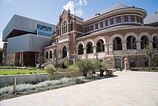
Perth is the capital and largest city of the Australian state of Western Australia (WA). It is the fourth most populous city in Australia and Oceania, with a population of 2.1 million living in Greater Perth in 2020. Perth is part of the South West Land Division of Western Australia, with most of the metropolitan area on the Swan Coastal Plain between the Indian Ocean and the Darling Scarp. The city has expanded outward from the original British settlements on the Swan River, upon which the city's central business district and port of Fremantle are situated. Perth is located on the traditional lands of the Whadjuk Noongar people, where Aboriginal Australians have lived for at least 38,000 years.

Western Australia is a state occupying the western 33 percent of the land area of Australia excluding external territories. It is bounded by the Indian Ocean to the north and west, and the Southern Ocean to the south, the Northern Territory to the north-east, and South Australia to the south-east. Western Australia is Australia's largest state, with a total land area of 2,527,013 square kilometres (975,685 sq mi). It is the second-largest country subdivision in the world, surpassed only by Russia's Sakha Republic. As of 2021, the state has about 2.68 million inhabitants – around 10 percent of the national total. The vast majority live in the south-west corner; 79 percent of the population lives in the Perth area, leaving the remainder of the state sparsely populated.
Bunbury is a coastal city in the Australian state of Western Australia, approximately 175 kilometres (109 mi) south of the state capital, Perth. It is the state's third most populous city after Perth and Mandurah, with a population of approximately 75,000.

Rottnest Island, colloquially often referred to as "Rotto", is a 19-square-kilometre (7.3 sq mi) island off the coast of Western Australia, located 18 kilometres (11 mi) west of Fremantle. A sandy, low-lying island formed on a base of aeolianite limestone, Rottnest is an A-class reserve, the highest level of protection afforded to public land. Together with Garden Island, Rottnest Island is a remnant of Pleistocene dune ridges.
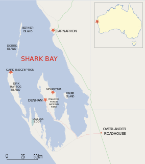
Dirk Hartog Island is an island off the Gascoyne coast of Western Australia, within the Shark Bay World Heritage Area. It is about 80 kilometres long and between 3 and 15 kilometres wide and is Western Australia's largest and most western island. It covers an area of 620 square kilometres and is approximately 850 kilometres north of Perth. It was named after Dirk Hartog, a Dutch sea captain, who first encountered the Western Australian coastline close to the 26th parallel south latitude, which runs through the island. After leaving the island, Hartog continued his voyage north-east along the mainland coast. Hartog gave the Australian mainland one of its earliest known names, as Eendrachtsland, which he named after his ship Eendracht, meaning "concord". The island is now the location of a major environmental reconstruction project, Return to 1616, that has seen all introduced livestock and feral animals removed, with eleven native species now in various stages of reintroduction.
The Swan River Colony, also known as the Swan River Settlement, or just Swan River, was a British colony established in 1829 on the Swan River, in Western Australia. This initial settlement place on the Swan River was soon named Perth, and it became the capital city of Western Australia.

The Shark Bay Marine Park is protected marine park located within the UNESCO World Heritage–listed Shark Bay, in the Gascoyne region of Western Australia. The 748,725-hectare (1,850,140-acre) marine park is situated over 800 km (500 mi) north of Perth and 400 kilometres (250 mi) north of Geraldton.

The Western Force is an Australian professional rugby union team based in Perth, Western Australia, currently competing in Super Rugby AU and Super Rugby Trans-Tasman. They previously played in Super Rugby from 2006 until they were axed from the competition in 2017. Following their axing they played in the National Rugby Championship in 2018 and 2019, replacing the Perth Spirit, and Global Rapid Rugby from 2018 to 2020, an Indo-Pacific competition organised by Andrew Forrest.

King George Sound is the name of a sound on the south coast of Western Australia. Originally named King George the Third's Sound, it was referred to as King George's Sound from 1805. The name "King George Sound" gradually came into use from about 1934, prompted by new Admiralty charts supporting the intention to eliminate the possessive 's' from geographical names.

The Ningaloo Coast is a World Heritage Site located in the north west coastal region of Western Australia. The 705,015-hectare (1,742,130-acre) heritage-listed area is located approximately 1,200 kilometres (750 mi) north of Perth, along the East Indian Ocean. The distinctive Ningaloo Reef that fringes the Ningaloo Coast is 260 kilometres (160 mi) long and is Australia's largest fringing coral reef and the only large reef positioned very close to a landmass. The Muiron Islands and Cape Farquhar are within this coastal zone.

Geographe Bay is in the south-west of Western Australia around 220 km southwest of Perth.

The Shire of Capel is a local government area in the South West region of Western Australia, taking in the land between the cities of Bunbury and Busselton about 200 kilometres (124 mi) south of the state capital, Perth. The Shire covers an area of 557.6 square kilometres (215.3 sq mi), and its seat of government is the town of Capel.
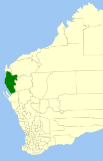
The Shire of Carnarvon is a local government area in the Gascoyne region of Western Australia, located about 900 kilometres (560 mi) north of the state capital, Perth. The Shire covers an area of 46,664 square kilometres (18,017 sq mi), and its seat of government is the town of Carnarvon. The major industries in the area are wool, agriculture and, more recently, tourism.

The Lacepede Islands, sometimes referred to simply as the Lacepedes, are a group of four islands lying off the Kimberley coast of Western Australia, about 120 kilometres north of Broome.
Western Australia has the longest coastline of any state or territory in Australia, at 10,194 km or 12,889 km. It is a significant portion of the coastline of Australia, which is 35,877 km.
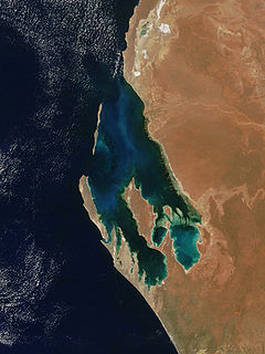
Peron Peninsula is a long narrow peninsula located in the Shark Bay World Heritage site in Western Australia, at about 25°51' S longitude and 113°30' E latitude. It is some 130 kilometres (81 mi) long, running north-northwesterly, located east of Henri Freycinet Harbour and west of Havre Hamelin and Faure Island. It is the largest of the Shark Bay peninsulas. Significant settlements include Denham and Monkey Mia. An airport is located there. It is the location of former Pastoral leases Peron and Nanga stations. It is the main location of land access to points within the World Heritage site. The northern area contains the Francois Peron National Park. It is surrounded by the Shark Bay Marine Park and its lower southeast part is adjacent to the Hamelin Pool Marine Nature Reserve.

Geelvink Channel is a feature to the east of the Houtman Abrolhos in the Indian Ocean off the coast of Western Australia, that lies between the Abrolhos and the port of Geraldton.
The Ngari Capes Marine Park is a marine protected area on the lower south west coast of Western Australia, located approximately 250 kilometres (160 mi) south of Perth. The 123,790-hectare (305,900-acre) marine park was gazetted on 12 June 2012 and the park's western and southern boundaries are the limit of coastal waters of Western Australia, abutting the South-west Corner Marine Park located within the Australian Commonwealth exclusive economic zone.

CinefestOZ is an annual film festival that takes place over five days in the South West region of Western Australia. IndigifestOZ is a section of the festival devoted to Aboriginal and Torres Strait Islander filmmakers. The CinefestOZ Film Prize of A$100,000 is the richest film prize in the country.