Related Research Articles

A geographer is a physical scientist, social scientist or humanist whose area of study is geography, the study of Earth's natural environment and human society, including how society and nature interacts. The Greek prefix "geo" means "earth" and the Greek suffix, "graphy," meaning "description," so a geographer is someone who studies the earth. The word "geography" is a Middle French word that is believed to have been first used in 1540.

Augustus Heinrich Petermann was a German cartographer.

Alexander Keith Johnston FRSE FRGS FGS FEGS LLD was a Scottish geographer and cartographer.

John Bartholomew was a Scottish cartographer.

Jean-Baptiste Bourguignon d'Anville was a French geographer and cartographer who greatly improved the standards of map-making. D'Anville became cartographer to the king, who purchased his cartographic materials, the largest collection in France. He made more than 200 maps during his lifetime, which are characterized by a careful, accurate work largely based on original research. In particular, D'Anville left unknown areas of continents blank and noted doubtful information as such, contrary to the lavish maps of his predecessors. His maps remained the reference point in cartography throughout the 19th century and were used by numerous explorers and travellers.

Eduard Imhof was a professor of cartography at the Swiss Federal Institute of Technology, Zürich, from 1925 to 1965. His fame, which extends far beyond the Institute of Technology, stems from his relief shading work on school maps and atlases. Between 1922 and 1973 Imhof worked on many school maps. He drew and shaded maps of Switzerland as well her various cantons and the Austrian province of Vorarlberg.

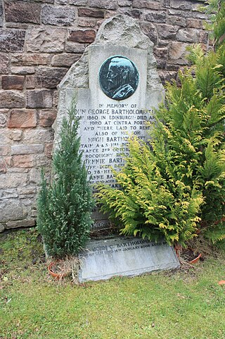
John George Bartholomew was a Scottish cartographer and geographer. As a holder of a royal warrant, he used the title "Cartographer to the King"; for this reason he was sometimes known by the epithet "the Prince of Cartography".
Charles William John Withers, is a British historical geographer and academic. He has been the Geographer Royal for Scotland since 2015, and held the Ogilvie Chair of Geography at the University of Edinburgh from 1994 to 2019.
The history of cartography refers to the development and consequences of cartography, or mapmaking technology, throughout human history. Maps have been one of the most important human inventions for millennia, allowing humans to explain and navigate their way through the world.
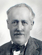
John Christopher Bartholomew was a Scottish cartographer and geographer.
John Bartholomew, generally known as Ian Bartholomew was a Scottish cartographer and geographer.

Geography is a field of science devoted to the study of the lands, features, inhabitants, and phenomena of Earth. The first recorded use of the word γεωγραφία was as a title of a book by Greek scholar Eratosthenes. Geography is an all-encompassing discipline that seeks an understanding of Earth and its human and natural complexities—not merely where objects are, but also how they have changed and come to be. While geography is specific to Earth, many concepts can be applied more broadly to other celestial bodies in the field of planetary science. One such concept, the first law of geography, proposed by Waldo Tobler, is "everything is related to everything else, but near things are more related than distant things." Geography has been called "the world discipline" and "the bridge between the human and the physical sciences."
Borden D. Dent (1938–2000) was an American geographer and cartographer who served as professor emeritus and chairman of the Department of Geography and Anthropology at Georgia State University. His textbook, Cartography: Thematic Map Design, is one of the seminal texts in the field, and its sixth edition was reissued in 2009.

Prof James Wreford Watson FRSE FRSC IBG LLD was a Scottish Canadian geographer and cartographer, who served as the Chief Geographer of Canada and the first president of the Canadian Association of Geographers. He was also a poet who wrote under the name James Wreford and was the recipient of Canada's top literary honor, the Governor General's Award, for his poetry.
John Terry Coppock CBE FBA FRSE was a British geographer who was the Ogilvie Professor of Human Geography at University of Edinburgh from 1966 to 1986 and Secretary and Treasurer of the Carnegie Trust for the Universities of Scotland from 1986 to 2000. He was a pioneer in three areas of scholarship – agricultural geography, land-use management and computer applications.
Marion Isabel Newbigin was a Scottish geographer, biologist and academic author. She was noted for her book Animal Geography, a key work in the field of animal geography/zoogeography, and as editor of the Scottish Geographical Magazine.

Alexander James Kent is a British cartographer, geographer and academic. He is Reader in Cartography and Geographical Information Science at Canterbury Christ Church University and a senior research associate of the Oxford Centre for Islamic Studies at the University of Oxford.

Caleb George Cash (1857–1916), honorary fellow of the Royal Scottish Geographical Society (FRSGS), was a geographer, passionate mountaineer, and music and geography teacher, known for his work on preserving the maps of medieval Scotland made by Timothy Pont (c.1560–c.1627), which formed the basis for the Blaeu Atlas of Scotland, and for organizing and publishing a bibliography compiled by Arthur Mitchell throughout Mitchell's life. Born in Birmingham, England, educated in London, and having worked in the North of England for a while, in his 30s he settled in Scotland and pioneered climbing in the Cairngorms, a mountain range in the eastern part of the Scottish Highlands.
Technical geography is one of three main branches of geography and involves using, studying, and creating tools to obtain, analyze, interpret, and understand spatial information. The other two branches, human geography and physical geography, can usually apply the concepts and techniques of technical geography. However, a technical geographer may be more concerned with the spatial and technological concepts than the nature of the data. Thus, the spatial data types a technical geographer employs may vary widely, including human and physical geography topics, with the common thread being the techniques and philosophies employed. Within the branch of technical geography are the major and overlapping subbranches of geographic information science, geomatics, and geoinformatics. Technical geography is a product of geography's quantitative revolution.
References
- ↑ "Geographer Royal for Scotland". Royal Scottish Geographical Society . Retrieved 30 August 2021.
- 1 2 "Researcher appointed Geographer Royal". The University of Edinburgh.
- 1 2 3 "First Geographer Royal for Scotland in 118 years appointed". BBC News . Retrieved 30 August 2021.
- ↑ Cassell (1900). Cassells Encyclopaedia Of General Information Vol 6. London: Cassell and Company Ltd. p. 91.
- ↑ Altic, Mirela (2017). Dissemination of Cartographic Knowledge: 6th International Symposium of the ICA Commission on the History of Cartography. Springer. p. 181. ISBN 9783319615158.
- ↑ "First Geographer Royal for Scotland in 118 years". Herald Scotland . Retrieved 30 August 2021.
| | This job-, occupation-, or vocation-related article is a stub. You can help Wikipedia by expanding it. |
| | This Scotland-related article is a stub. You can help Wikipedia by expanding it. |