
A geographic information system (GIS) consists of integrated computer hardware and software that store, manage, analyze, edit, output, and visualize geographic data. Much of this often happens within a spatial database, however, this is not essential to meet the definition of a GIS. In a broader sense, one may consider such a system also to include human users and support staff, procedures and workflows, the body of knowledge of relevant concepts and methods, and institutional organizations.

The University of Shanghai for Science and Technology is a municipal public university located in Shanghai, China. The university is affiliated with and sponsored by the Municipality of Shanghai.

.cn is the country code top-level domain (ccTLD) for the People's Republic of China. Introduced on 28 November 1990, the domain is administered by China Internet Network Information Center, a public institution affiliated with the Ministry of Industry and Information. The domain is the largest ccTLD in the world.

Geoinformatics is a technical science primarily within the domain of Computer Science. It focuses on the programming of applications, spatial data structures, and the analysis of objects and space-time phenomena related to the surface and underneath of Earth and other celestial bodies. The field develops software and web services to model and analyse spatial data, serving the needs of geosciences and related scientific and engineering disciplines. The term is often used interchangeably with Geomatics, although the two have distinct focuses; Geomatics emphasizes acquiring spatial knowledge and leveraging information systems, not their development.

Pengzhou, formerly Peng County or Pengxian, is a county-level city of Sichuan Province, Southwest China, it is under the administration of the prefecture-level city of Chengdu. There is an expressway that connects Pengzhou to Chengdu. It is bordered by the prefecture-level divisions of Deyang to the northeast and the Ngawa Tibetan and Qiang Autonomous Prefecture to the north.
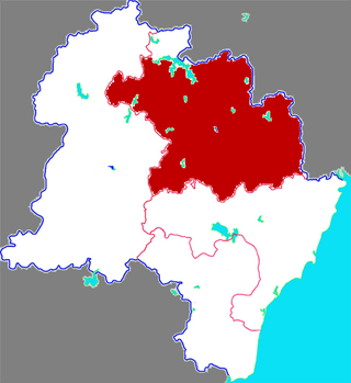
Wulian County is a county of the prefecture-level city of Rizhao, Shandong. The county is known for and named after its eponymous Wulian Mountain. It borders Zhucheng to the north, Donggang District to the south, Ju County to the west and Xihai'an to the east.
Huojia County is a county under the administration of the prefecture-level city of Xinxiang, in the northwest of Henan province, China.

The 2008 Panzhihua earthquake struck southern Sichuan province, China on August 30 at with a surface wave magnitude of 6.1, or 6.0 . It is also cited as the Renhe-Huili earthquake, especially in SCEA reports and early CEA reports. It was not an aftershock of the Sichuan earthquake that occurred several months prior. With more than 400 aftershocks, it caused over 40 deaths, the collapse of 10,000 homes and damage to other infrastructure in the provinces of Sichuan and Yunnan. The maximum liedu was VIII.
The 2008 Yingjiang earthquakes were a series of major earthquakes ranging from surface wave magnitude (Ms) 4.1 to 5.9 that struck Yingjiang County, Yunnan province, China between August 19 and September 3. It caused 5 deaths, 130 injuries, and RMB 2.7 billion in direct economic damage. USGS put the magnitude of the strongest one to Mw 6.0.
The Barrow Area Information Database (BAID) is designed to support Arctic science with a special focus on the research hubs of Barrow, Atqasuk, and Ivotuk on the North Slope of Alaska.
Dongming County in Heze Prefecture is the westernmost county of Shandong Province in the People's Republic of China. It borders Henan Province to the west across the Yellow River. Dongming County had a population of 677,563 in 1999.
Pingyu County is a county of Henan province, China, bordering Anhui province to the east. It is under the administration of Zhumadian city.
Xintian County is a county of Hunan Province, China, it is under the administration of the prefecture-level city of Yongzhou.
Under Chinese law, the use of geographic information in the People's Republic of China is restricted to entities that have special authorization from the administrative department for surveying and mapping under the State Council. Consequences of the restriction include fines for unauthorized surveys, lack of geotagging information on many cameras when the GPS chip detects a location within China, incorrect alignment of street maps with satellite maps in various applications, and the criminalization of crowdsourced mapping efforts such as OpenStreetMap.

The People's Liberation Army Strategic Support Force is the space, cyber, political, and electronic warfare force and the 5th branch of the People's Liberation Army (PLA). It was established in December 2015 as part of the first wave of the Chinese military reforms.
The Global Navigation Grid Code (GNGC) is a Chinese-developed point reference system designed for global navigation. It is similar in design to national grid reference systems used throughout the world. GNGC was based upon the work of the GeoSOT team, headquartered in the Institute of Remote Sensing and GIS, Peking University. The concept for this system was proposed in 2015 in Bin Li's dissertation: Navigation Computing Model of Global Navigation Grid Code. GNGC allows easy calculation of space and spatial indexes and can be extended to the provide navigation mesh coding. Along with the Beidou navigation system, GNGC provides independent intellectual property rights, globally applicable standards and global navigation trellis code.
The 2017 Jiuzhaigou earthquake occurred on 8 August 2017, in Zhangzha Town, Jiuzhaigou County, Ngawa Prefecture, Sichuan Province, China. The earthquake was registered at 7.0 and killed at least 25 people in the mountainous region of northern Sichuan.
The China University of Geosciences (Beijing) is a public university located in Beijing, China. It is affiliated with the Ministry of Education, and co-sponsored by the Ministry of Education and the Ministry of Natural Resources. The university is part of the Double First Class University Plan and Project 211.
Chen Jun is a Chinese geographer and formerly director and chief engineer of the National Geomatics Center of China (NGCC). He was president of the International Society for Photogrammetry and Remote Sensing (ISPRS) between 2012 and 2016. He served two separate terms as president of the China Association for Geographic Information Society (CAGIS) from 1999 to 2003 and 2003 to 2007. He is a member of the China Land Science Society (CLSS).
Sun Jiulin was a Chinese engineer specializing in resource science, and an academician of the Chinese Academy of Engineering.