The Baltic Sea is an arm of the Atlantic Ocean that is enclosed by Denmark, Estonia, Finland, Germany, Latvia, Lithuania, Poland, Russia, Sweden, and the North and Central European Plain.

The Gulf of Finland is the easternmost arm of the Baltic Sea. It extends between Finland to the north and Estonia to the south, to Saint Petersburg in Russia to the east, where the river Neva drains into it. Other major cities around the gulf include Helsinki and Tallinn. The eastern parts of the Gulf of Finland belong to Russia, and some of Russia's most important oil harbors are located farthest in, near Saint Petersburg. As the seaway to Saint Petersburg, the Gulf of Finland has been and continues to be of considerable strategic importance to Russia. Some of the environmental problems affecting the Baltic Sea are at their most pronounced in the shallow gulf. Proposals for a tunnel through the gulf have been made.

Lake Ladoga is a freshwater lake located in the Republic of Karelia and Leningrad Oblast in northwestern Russia, in the vicinity of Saint Petersburg.

The Neva is a river in northwestern Russia flowing from Lake Ladoga through the western part of Leningrad Oblast to the Neva Bay of the Gulf of Finland. Despite its modest length of 74 kilometres (46 mi), it is the fourth-largest river in Europe in terms of average discharge.
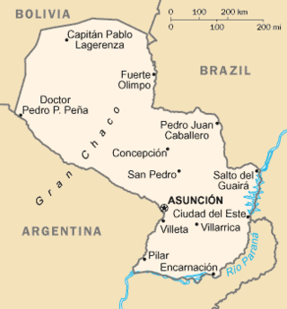
Paraguay is a country in South America, bordering Argentina, Bolivia and Brazil. The Paraguay River divides the country into strikingly different eastern and western regions. Both the eastern region and the western region gently slope toward and are drained into the Paraguay River, which separates and unifies the two regions. With the Paraneña region reaching southward and the Chaco extending to the north, Paraguay straddles the Tropic of Capricorn and experiences both subtropical and tropical climates.
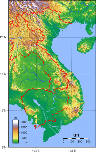
Vietnam is located on the eastern margin of the Indochinese peninsula and occupies about 331,211.6 square kilometres (127,881.5 sq mi), of which about 25% was under cultivation in 1987. It borders the Gulf of Tonkin, Gulf of Thailand, and Pacific Ocean, along with China, Laos, and Cambodia. The elongated roughly S shaped country has a north-to-south distance of 1,650 km (1,030 mi) and is about 50 km (31 mi) wide at the narrowest point. With a coastline of 3,260 km (2,030 mi), excluding islands, Vietnam claims 12 nautical miles as the limit of its territorial waters, an additional 12 nautical miles as a contiguous customs and security zone. It has an exclusive economic zone of 417,663 km2 (161,261 sq mi) with 200 nautical miles.

The White Sea is a southern inlet of the Barents Sea located on the northwest coast of Russia. It is surrounded by Karelia to the west, the Kola Peninsula to the north, and the Kanin Peninsula to the northeast. The whole of the White Sea is under Russian sovereignty and considered to be part of the internal waters of Russia. Administratively, it is divided between the Arkhangelsk and Murmansk oblasts and the Republic of Karelia.
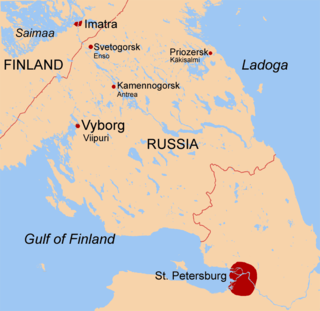
The Karelian Isthmus is the approximately 45–110-kilometre-wide (30–70 mi) stretch of land situated between the Gulf of Finland and Lake Ladoga in northwestern Russia, to the north of the River Neva. Its northwestern boundary is a line from the Bay of Vyborg to the westernmost point of Lake Ladoga, Pekonlahti. If the Karelian Isthmus is defined as the entire territory of present-day Saint Petersburg and Leningrad Oblast to the north of the Neva and also a tiny part of the Republic of Karelia, the area of the isthmus is about 15,000 km2 (5,800 sq mi).

Kronstadt is a Russian port city in Kronshtadtsky District of the federal city of Saint Petersburg, located on Kotlin Island, 30 km (19 mi) west of Saint Petersburg, near the head of the Gulf of Finland. It is linked to the former Russian capital by a combination levee-causeway-seagate, the St Petersburg Dam, part of the city's flood defences, which also acts as road access to Kotlin island from the mainland.

Kotlin is a Russian island, located near the head of the Gulf of Finland, 32 kilometres (20 mi) west of Saint Petersburg in the Baltic Sea. Kotlin separates the Neva Bay from the rest of the gulf. The fortified city of Kronstadt is located on the island and forms part of a World Heritage Site that is Saint Petersburg and Related Groups of Monuments. The island serves as a gateway to Saint Petersburg and as such has been the site of several military engagements.

The Izhora, also known as the Inger, is a left tributary of the Neva on its run through Ingria in northwestern Russia from Lake Ladoga to the Gulf of Finland. The Izhora flows through Gatchinsky and Tosnensky Districts of Leningrad Oblast as well as through Pushkinsky and Kolpinsky Districts of the federal city of Saint Petersburg. The settlement of Ust-Izhora is situated at the confluence of Izhora and Neva, halfway between Saint Petersburg and Shlisselburg. The towns of Kommunar and Kolpino are located on the Izhora as well. The river is noted as the farthest Swedish forces ever reached between the Viking Age and the Time of Troubles.

The Saint Petersburg Flood Prevention Facility Complex, unofficially the Saint Petersburg Dam, is a 25 km (16 mi) long complex of dams for flood control near Saint Petersburg, Russia. The dam extends from Lomonosov northward to Kotlin Island, then turns east toward Cape Lisiy Nos near Sestroretsk.
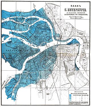
Floods in Saint Petersburg refer to a rise of water on the territory of St. Petersburg, a major city in Russia and its former capital. They are usually caused by the overflow of the delta of Neva River and surging water in the eastern part of Neva Bay but sometimes caused by melting snow. Floods are registered when the water rises above 160 cm with respect to a gauge at the Saint Petersburg Mining Institute. More than 300 floods have occurred since the city was founded in 1703.

St. Petersburg is a major trade gateway, financial and industrial center of Russia specialising in oil and gas trade, shipbuilding yards, aerospace industry, radio and electronics, software and computers; machine building, heavy machinery and transport, including tanks and other military equipment, mining, instrument manufacture, ferrous and nonferrous metallurgy, chemicals, pharmaceuticals, medical equipment, publishing and printing, food and catering, wholesale and retail, textile and apparel industries, and many other businesses.
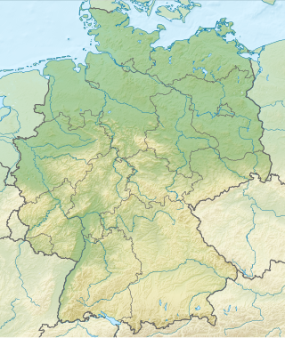
Germany is a country in Central and Western Europe that stretches from the Alps, across the North European Plain to the North Sea and the Baltic Sea. It is the second-most populous country in Europe after Russia, and is seventh-largest country by area in the continent. The area of Germany ranked 63rd and covers 357,021 km2 (137,847 sq mi), consisting of 349,223 km2 (134,836 sq mi) of land and 7,798 km2 (3,011 sq mi) of waters, smaller than Japan but larger than Republic of the Congo.
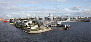
The Great Port of St. Petersburg or Port of St. Petersburg is a major seaport serving the city of St. Petersburg in northwest Russia. The port's water area is 164.6 km2. The mooring line is 31 km long and the water is 25 metres (82 ft) deep at the port's deepest anchorages. Since 2011, the port has been under the authority of a state-owned enterprise, the Port Authority of the Great Port of St. Petersburg. This agency oversees commercial navigation in the seaport of St. Petersburg and beyond in the designated areas of responsibility of the Russian Federation.

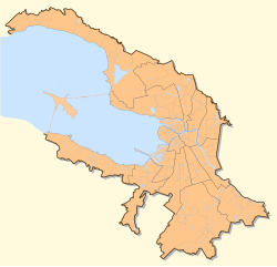
Saint Petersburg, formerly known as Petrograd and later Leningrad, is the second-largest city in Russia after Moscow. It is situated on the River Neva, at the head of the Gulf of Finland on the Baltic Sea. The city had a population of roughly 5.6 million residents as of 2021, with more than 6.4 million people living in the metropolitan area. Saint Petersburg is the fourth-most populous city in Europe, the most populous city on the Baltic Sea, and the world's northernmost city of more than 1 million residents. As Russia's Imperial capital, and a historically strategic port, it is governed as a federal city.

The Peterhof Palace is a series of palaces and gardens located in Petergof, Saint Petersburg, Russia, commissioned by Peter the Great as a direct response to the Palace of Versailles by Louis XIV of France. Originally intending it in 1709 for country habitation, Peter the Great sought to expand the property as a result of his visit to the French royal court in 1717, inspiring the nickname of "The Russian Versailles". The architect between 1714 and 1728 was Domenico Trezzini, and the style he employed became the foundation for the Petrine Baroque style favored throughout Saint Petersburg. Also in 1714, Jean-Baptiste Alexandre Le Blond, likely chosen due to his previous collaborations with Versailles landscaper André Le Nôtre, designed the gardens. Francesco Bartolomeo Rastrelli completed an expansion from 1747 to 1756 for Elizabeth of Russia. The palace-ensemble along with the city center is recognized as a UNESCO World Heritage Site.

Saint Petersburg – second-largest city in Russia. An important Russian port on the Baltic Sea, it has the status of a federal subject. Its name was changed to "Petrograd" in 1914, then to "Leningrad" in 1924, and back to Saint Petersburg in 1991.