
Notre Dame is a census-designated place north of the city of South Bend in St. Joseph County, in the U.S. state of Indiana. It includes the campuses of three colleges: the University of Notre Dame, Saint Mary's College, and Holy Cross College. Notre Dame is split between Clay and Portage Townships. As of the 2020 census, its population was 6,342.

Badakhshan Province, Badaxšān) is one of the 34 provinces of Afghanistan, located in the farthest north-eastern part of the country between Tajikistan and Pakistan's Gilgit-Baltistan region. It shares a 56.5-mile (91 km) border with China.
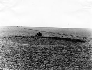
The High Plains are a subregion of the Great Plains mostly in the Western United States, but also partly in the Midwest states of Nebraska, Kansas, and South Dakota, generally encompassing the western part of the Great Plains before the region reaches the Rocky Mountains. The High Plains are located in eastern Montana, southeastern Wyoming, southwestern South Dakota, western Nebraska, eastern Colorado, western Kansas, eastern New Mexico, western Oklahoma, and to just south of the Texas Panhandle. The southern region of the Western High Plains ecology region contains the geological formation known as Llano Estacado which can be seen from a short distance or on satellite maps. From east to west, the High Plains rise in elevation from around 1,800 to 7,000 feet.

Mining in Australia has long been a significant primary sector industry and contributor to the Australian economy by providing export income, royalty payments and employment. Historically, mining booms have also encouraged population growth via immigration to Australia, particularly the gold rushes of the 1850s. Many different ores, gems and minerals have been mined in the past and a wide variety are still mined throughout the country.

The geology of Georgia consists of four distinct geologic regions, beginning in the northwest corner of the state and moving through the state to the southeast: the Valley and Ridge region, also known as the Appalachian Plateau; the Blue Ridge; the Piedmont and the Coastal Plain. The Fall Line is the boundary between the Piedmont and the Coastal Plain.

The Midcontinent Rift System (MRS) or Keweenawan Rift is a 2,000 km (1,200 mi) long geological rift in the center of the North American continent and south-central part of the North American plate. It formed when the continent's core, the North American craton, began to split apart during the Mesoproterozoic era of the Precambrian, about 1.1 billion years ago. The rift failed, leaving behind thick layers of igneous rock that are exposed in its northern reaches, but buried beneath later sedimentary formations along most of its western and eastern arms. Those arms meet at Lake Superior, which is contained within the rift valley. The lake's north shore in Ontario and Minnesota defines the northern arc of the rift. From the lake, the rift's eastern arm trends south to central lower Michigan, and possibly into Indiana, Ohio, Kentucky, Tennessee, and Alabama. The western arm runs from Lake Superior southwest through portions of Wisconsin, Minnesota, Iowa, and Nebraska to northeastern Kansas, and possibly into Oklahoma.

The Sirte Basin is a late Mesozoic and Cenozoic triple junction continental rift along northern Africa that was initiated during the late Jurassic Period. It borders a relatively stable Paleozoic craton and cratonic sag basins along its southern margins. The province extends offshore into the Mediterranean Sea, with the northern boundary drawn at the 2,000 meter (m) bathymetric contour. It borders in the north on the Gulf of Sidra and extends south into northern Chad.
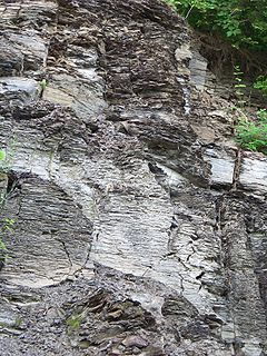
The Marcellus Formation or the Marcellus Shale is a Middle Devonian age unit of sedimentary rock found in eastern North America. Named for a distinctive outcrop near the village of Marcellus, New York, in the United States, it extends throughout much of the Appalachian Basin.
The geology of Alabama is marked by abundant geologic resources and a variety of geologic structures from folded mountains in the north to sandy beaches along the Gulf of Mexico coast. Alabama spans three continental geologic provinces as defined by the United States Geological Survey, the Atlantic Plain, Appalachian Highlands, and Interior Plains. The Geological Survey of Alabama breaks these provinces down into more specific physiographic provinces.

Mining in Afghanistan is controlled by the Ministry of Mines and Petroleum, which is headquartered in Kabul with regional offices in other parts of the country. Afghanistan has over 1,400 mineral fields, containing barite, chromite, coal, copper, gold, iron ore, lead, natural gas, petroleum, precious and semi-precious stones, salt, sulfur, talc, and zinc, among many other minerals. Gemstones include high-quality emerald, lapis lazuli, red garnet and ruby. According to a joint study by The Pentagon and the United States Geological Survey, Afghanistan has an estimated US$1 trillion of untapped minerals.
In 2006, Cambodia's mineral resources remained, to a large extent, unexplored. Between 2003 and 2006, however, foreign investors from Australia, China, South Korea, Thailand, and the United States began to express their interest in Cambodia's potential for offshore oil and gas as well as such land-based metallic minerals as bauxite, copper, gold, and iron ore, and such industrial minerals as gemstones and limestone.

A geologist is a scientist who studies the solid, liquid, and gaseous matter that constitutes the Earth and other terrestrial planets, as well as the processes that shape them. Geologists usually study geology, although backgrounds in physics, chemistry, biology, and other sciences are also useful. Field work is an important component of geology, although many subdisciplines incorporate laboratory work.
Offshore oil and gas in the United States provides a large portion of the nation’s oil and gas supply. Large oil and gas reservoirs are found under the sea offshore from Louisiana, Texas, California, and Alaska. Environmental concerns have prevented or restricted offshore drilling in some areas, and the issue has been hotly debated at the local and national levels.
The geologic map of Georgia is a special-purpose map made to show geological features. Rock units or geologic strata are shown by colors or symbols to indicate where they are exposed at the surface. Structural features such as faults and shear zones are also shown. Since the first national geological map, in 1809, there have been numerous maps which included the geology of Georgia. The first Georgia specific geologic map was created in 1825. The most recent state-produced geologic map of Georgia, by the Georgia Department of Natural Resources is 1:500,000 scale, and was created in 1976 by the department's Georgia Geological Survey. It was generated from a base map produced by the United States Geological Survey. The state geologist and Director of the Geological Survey of Georgia was Sam M. Pickering, Jr. Since 1976, several geological maps of Georgia, featuring the state's five distinct geologic regions, have been produced by the federal government.

The United States Geological Survey is a scientific agency of the United States government. The scientists of the USGS study the landscape of the United States, its natural resources, and the natural hazards that threaten it. The organization's work spans the disciplines of biology, geography, geology, and hydrology. The USGS is a fact-finding research organization with no regulatory responsibility.
Offshore oil and gas in the Gulf of Mexico is a major source of oil and natural gas in the United States. The western and central Gulf of Mexico, which includes offshore Texas, Louisiana, Mississippi, and Alabama, is one of the major petroleum-producing areas of the United States. Oil production from US federal waters in the Gulf of Mexico reached an all-time annual high of 1.65 million barrels per day in 2017. Oil production is expected to continue the upward trend in 2018 and 2019, based on ten new oil fields which are planned to start production in those years. According to the Energy Information Administration, "Gulf of Mexico federal offshore oil production accounts for 17% of total U.S. crude oil production and federal offshore natural gas production in the Gulf accounts for 5% of total U.S. dry production."

The mining industry of Yemen is at present dominated by fossil mineral of petroleum and liquefied natural gas (LNG), and to a limited extent by extraction of dimension stone, gypsum, and refined petroleum. Reserves of metals like cobalt, copper, gold, iron ore, nickel, niobium, platinum-group metals, silver, tantalum, and zinc are awaiting exploration. Industrial minerals with identified reserves include black sands with ilmenite, monazite, rutile, and zirconium, celestine, clays, dimension stone, dolomite, feldspar, fluorite, gypsum, limestone, magnesite, perlite, pure limestone, quartz, salt, sandstone, scoria, talc, and zeolites; some of these are under exploitation.
The Purcell Supergroup is composed primarily of argillites, carbonate rocks, quartzites, and mafic igneous rocks of late Precambrian (Mesoproterozoic) age. It is present in an area of about 15,000 km2 in southwestern Alberta and southeastern British Columbia, Canada, and it extends into the northwestern United States where it is called the Belt Supergroup. It was named for the Purcell Mountains of British Columbia by R.A. Daly in 1912. Fossil stromatolites and algal structures are common in some of the Purcell Supergroup rocks, and the Sullivan ore body at Kimberley, British Columbia, a world-class deposit of lead, zinc, and silver, lies within the Alderidge Formation in the lower part of the Purcell.
The Pachuca Range is a mountain range in the Sierra Madre Oriental of central Mexico, in the state of Hidalgo.

