Geotagged photograph

Last updated
Above: Map showing photographer's view (
.mw-parser-output .geo-default,.mw-parser-output .geo-dms,.mw-parser-output .geo-dec{display:inline}.mw-parser-output .geo-nondefault,.mw-parser-output .geo-multi-punct,.mw-parser-output .geo-inline-hidden{display:none}.mw-parser-output .longitude,.mw-parser-output .latitude{white-space:nowrap}
59deg19'39''N 18deg04'21''E / 59.3275degN 18.0725degE / 59.3275; 18.0725) of two buildings at a distance of 270 meters (
59deg19'42''N 18deg04'38''E / 59.3284degN 18.0772degE / 59.3284; 18.0772) and 1200 meters (
59deg19'45''N 18deg05'35''E / 59.3291degN 18.0931degE / 59.3291; 18.0931). Below: Which of the three locations should be associated with the resulting photo? Nationalmuseum-karta.png
Above: Map showing photographer's view ( 59°19′39″N18°04′21″E / 59.3275°N 18.0725°E / 59.3275; 18.0725 ) of two buildings at a distance of 270 meters ( 59°19′42″N18°04′38″E / 59.3284°N 18.0772°E / 59.3284; 18.0772 ) and 1200 meters ( 59°19′45″N18°05′35″E / 59.3291°N 18.0931°E / 59.3291; 18.0931 ). Below: Which of the three locations should be associated with the resulting photo? Nationalmuseum.jpg

A geotagged photograph is a photograph which is associated with a geographic position by geotagging. Usually this is done by assigning at least a latitude and longitude to the image, and optionally elevation, compass bearing and other fields may also be included.

Contents

In theory, every part of a picture can be tied to a geographic location, but in the most typical application, only the position of the photographer is associated with the entire digital image. This has implications for search and retrieval. For example, photos of a mountain summit can be taken from different positions miles apart. To find all images of a particular summit in an image database, all photos taken within a reasonable distance must be considered. The point position of the photographer can in some cases include the bearing, the direction the camera was pointing, as well as the elevation and the dilution of precision (DOP).

Methods

There are a few methods of geotagging photographs, either automatic or manual. Automatic methods provide the easiest and most precise method of geotagging an image, providing that a good signal has been acquired at the time of taking the photo.

Automatic using a built-in GPS

Several manufacturers offer cameras with a built-in GPS receiver, but most cameras with this capability are camera phones, as camera manufacturers after initial experience in the market came to treat GPS cameras as a niche market. [1] The 2008 Nikon P6000, for example, an early geotagging camera, was replaced in 2010 by the P7000 which lacked that feature. [2] Some models also include a compass to indicate the direction the camera was facing when the picture was taken.

Automatic using a connected GPS

Geotagger "Solmeta N2 Compass" + Nikon D5000 Solmeta N2 auf Nikon D5000 Rueckansicht.JPG
Geotagger "Solmeta N2 Compass" + Nikon D5000

The D1X and D1H that Nikon introduced in 2002 included a GPS interface. [3] In 2006 the first special GPS receiver for Nikon was produced by Dawntech. [4] Since 2009 Nikon has sold its own Geotagger GP-1. Canon uses the USB socket on the wireless file transmitter unit (WFT) as the GPS interface.

Some digital cameras and camera phones support an external GPS receiver connected by cable, or inserted into the memory card slot or flash shoe. The Samsung SH100 can connect using Wi-Fi to get position data from a GPS-enabled smartphone. [5] Generally the relevant GPS data is automatically stored in the photo's Exif information when the photo is taken. A connected GPS will generally remain switched on continuously, requiring power, and will then have location information available immediately when the camera is switched on.

Many GPS-ready cameras are currently available, made by manufacturers such as Nikon, Fujifilm, Sony and Panasonic. Automatic geotagging combined with real-time transfer and publishing results in real-time tagging.

Synchronizing with a separate GPS

Most cameras sold today do not contain a built-in GPS receiver; however, an external location-aware device, such as a hand-held GPS logger, can still be used with a non-GPS digital camera for geotagging. The photo is taken without geographical information and is processed later using software in conjunction with the GPS data. Timestamps made by the camera can be compared with timestamps in the recorded GPS information, provided that the clocks in the separate devices can be synchronized. The resulting coordinates can then be added to the Exif information of the photo.

Manual geotagging

Location information can also be added to photos, for example via its Exif specification that has fields for longitude/latitude, even if no GPS device was present when the photo was taken.

The information can be entered by directly giving the coordinates or by selecting a location from a map using software tools. Some tools allow entry of tags such as city, postal code or a street address. Geocoding and reverse geocoding can be used to convert between locations and addresses.

Manual geotagging also introduces possibilities of error, where a photograph's location is incorrectly represented by wrong coordinates. An advanced comparative analysis of such photos with the total collection set of all photos available from the surrounding coordinates, needs to be done to single out and flag such photos, but such a software's value, need and purpose could be limited in today's environment where almost every smartphone and camera have geotagging built-in and users do not need to manually enter this information.

Remote standoff capture

Screenshot from a U.S. Customs and Border Protection Predator UAV, showing the GPS position of the aircraft (red) and the target (blue) Predator screenshot.jpg
Screenshot from a U.S. Customs and Border Protection Predator UAV, showing the GPS position of the aircraft (red) and the target (blue)

Some manufacturers of military and professional mapping-grade GPS instruments have integrated a GPS receiver with a laser rangefinder and digital camera. These multi-functional tools are able to determine a remote subject's GPS position by calculating the subject's geographic location relative to the camera's GPS position. These instruments are commonly used in military applications when an aircraft or operator is targeting an area, the position is inaccessible (for example over a valley or wetland), there are personal health & safety concerns (motorway traffic), or the user wants to quickly capture multiple targets from a single, safe position (trees, street signage and furniture).

Civilian integrated GPS cameras with rangefinders and remote standoff capability are currently available made by manufacturers such as Ricoh and Surveylab.

Uses

When geotagged photos are uploaded to online sharing communities such as Flickr, Panoramio or Moblog, the photo can be placed onto a map to view the location the photo was taken. In this way, users can browse photos from a map, search for photos from a given area, and find related photos of the same place from other users.

Many smartphones automatically geotag their photos by default. Photographers who prefer not to reveal their location can turn this feature off. [6] Additionally smartphones can use their GPS to geotag photos taken with an external camera.

Geotagged photo location stamped with GPStamper GPS location stamped with GPStamper.jpg#file
Geotagged photo location stamped with GPStamper

Geotagged photos may be visually stamped with their GPS location information using software tools. A stamped photo affords universal and cross-platform viewing of the photo's location, and offers the security of retaining that location information in the event of metadata corruption, or if file metadata is stripped from a photo, e.g. when uploading to various online photo sharing communities.

Geotagging is also being used to determine social patterns. For example, Now app uses geotagged Instagram photos to find nearby events happening now. [7]

Formats

With photos stored in JPEG, TIFF and many other file formats, the geotag information, storing camera location and sometimes heading, is typically embedded in the metadata, stored in Exchangeable image file format (Exif) or Extensible Metadata Platform (XMP) format. These data are not visible in the picture itself but are read and written by special programs and most digital cameras and modern scanners. Latitude and longitude are stored in units of degrees with decimals. [8] This geotag information can be read by many programs, such as the cross-platform open source ExifTool. An example readout for a photo might look like:

GPS Latitude                    : 57 deg 38' 56.83" N GPS Longitude                   : 10 deg 24' 26.79" E GPS Position                    : 57 deg 38' 56.83" N, 10 deg 24' 26.79" E

or the same coordinates could also be presented as decimal degrees:

GPS Latitude                    : 57.64911 GPS Longitude                   : 10.40744 GPS Position                    : 57.64911 10.40744

When stored in Exif, the coordinates are represented as a series of rational numbers in the GPS sub-IFD. Here is a hexadecimal dump of the relevant section of the Exif metadata (with big-endian byte order):

+ [GPS directory with 5 entries] | 0)  GPSVersionID = 2 2 0 0 |     - Tag 0x0000 (4 bytes, int8u[4]): |         dump: 02 02 00 00 | 1)  GPSLatitudeRef = N |     - Tag 0x0001 (2 bytes, string[2]): |         dump: 4e 00  [ASCII "N\0"] | 2)  GPSLatitude = 57 38 56.83 (57/1 38/1 5683/100) |     - Tag 0x0002 (24 bytes, rational64u[3]): |         dump: 00 00 00 39 00 00 00 01 00 00 00 26 00 00 00 01 |         dump: 00 00 16 33 00 00 00 64 | 3)  GPSLongitudeRef = W |     - Tag 0x0003 (2 bytes, string[2]): |         dump: 57 00  [ASCII "W\0"] | 4)  GPS Longitude = 10 24 26.79 (10/1 24/1 2679/100) |     - Tag 0x0004 (24 bytes, rational64u[3]): |         dump: 00 00 00 0a 00 00 00 01 00 00 00 18 00 00 00 01 |         dump: 00 00 0a 77 00 00 00 64

See also

Related Research Articles

A waypoint is an intermediate point or place on a route or line of travel, a stopping point or point at which course is changed, the first use of the term tracing to 1880. In modern terms, it most often refers to coordinates which specify one's position on the globe at the end of each "leg" (stage) of an air flight or sea passage, the generation and checking of which are generally done computationally.

<span class="mw-page-title-main">Exif</span> Metadata standard in digital images

Exchangeable image file format is a standard that specifies formats for images, sound, and ancillary tags used by digital cameras, scanners and other systems handling image and sound files recorded by digital cameras. The specification uses the following existing encoding formats with the addition of specific metadata tags: JPEG lossy coding for compressed image files, TIFF Rev. 6.0 for uncompressed image files, and RIFF WAV for audio files. It does not support JPEG 2000 or GIF encoded images.

GPX, or GPS Exchange Format, is an XML schema designed as a common GPS data format for software applications. It can be used to describe waypoints, tracks, and routes. It is an open format and can be used without the need to pay license fees. Location data is stored in tags and can be interchanged between GPS devices and software. Common software applications for the data include viewing tracks projected onto various map sources, annotating maps, and geotagging photographs based on the time they were taken.

<span class="mw-page-title-main">Geotagging</span> Act of associating geographic coordinates to digital media

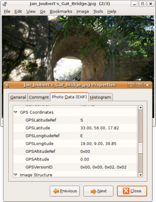
Geotagging, or GeoTagging, is the process of adding geographical identification metadata to various media such as a geotagged photograph or video, websites, SMS messages, QR Codes or RSS feeds and is a form of geospatial metadata. This data usually consists of latitude and longitude coordinates, though they can also include altitude, bearing, distance, accuracy data, and place names, and perhaps a time stamp.

Address geocoding, or simply geocoding, is the process of taking a text-based description of a location, such as an address or the name of a place, and returning geographic coordinates, frequently latitude/longitude pair, to identify a location on the Earth's surface. Reverse geocoding, on the other hand, converts geographic coordinates to a description of a location, usually the name of a place or an addressable location. Geocoding relies on a computer representation of address points, the street / road network, together with postal and administrative boundaries.

A camera raw image file contains unprocessed or minimally processed data from the image sensor of either a digital camera, a motion picture film scanner, or other image scanner. Raw files are so named because they are not yet processed, and contain large amounts of potentially redundant data. Normally, the image is processed by a raw converter, in a wide-gamut internal color space where precise adjustments can be made before conversion to a viewable file format such as JPEG or PNG for storage, printing, or further manipulation. There are dozens of raw formats in use by different manufacturers of digital image capture equipment.

<span class="mw-page-title-main">Point of interest</span>

A point of interest (POI) is a specific point location that someone may find useful or interesting. An example is a point on the Earth representing the location of the Eiffel Tower, or a point on Mars representing the location of its highest mountain, Olympus Mons. Most consumers use the term when referring to hotels, campsites, fuel stations or any other categories used in modern automotive navigation systems.

NavPix is the proprietary name applied by Navman to its technology that combines an image with geographical data.

Global Navigation Satellite System (GNSS) receivers, using the GPS, GLONASS, Galileo or BeiDou system, are used in many applications. The first systems were developed in the 20th century, mainly to help military personnel find their way, but location awareness soon found many civilian applications.

<span class="mw-page-title-main">FastPictureViewer</span>

FastPictureViewer is a freemium image viewer for Windows XP and later. Its aim is to facilitate quick review, rating and annotation of large quantities of digital images in the early steps of the digital workflow, with an emphasis on simplicity and speed. As an app with a freemium license, a basic version is available cost-free for personal, non-profit or educational uses, while a commercial license is required for the professional version with additional features. The basic version starts as a full version trial.

Real-time geotagging refers to the automatic technique of acquiring media, associating a specific location with the media, transferring the media to an online map and publishing the media in real time. It is thus an extension of an automatic geotagging process, requiring an in-built or attached location acquisition device, but also requires communication with a wireless data transfer device. Most modern smartphones and several digital cameras already integrate camera, aGPS, and wireless data transfer into one device, thus directly producing a geotagged photograph. Real-time geotagging is sometimes referred to as "mobile geotagging" or "autogeotagging", but this does not imply the real-time publishing step.

<span class="mw-page-title-main">Nikon Coolpix P6000</span> Digital camera model

The Coolpix P6000 is a digital camera introduced by the Nikon Corporation in August 2008.

<span class="mw-page-title-main">Nikon D90</span> Digital single-lens reflex camera

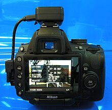
The Nikon D90 is a 12.3 megapixel digital single-lens reflex camera (DSLR) model announced by Nikon on August 27, 2008. It is a prosumer model that replaces the Nikon D80, fitting between the company's entry-level and professional DSLR models. It has a Nikon DX format crop sensor.

<span class="mw-page-title-main">Geo-fence</span> Virtual perimeter

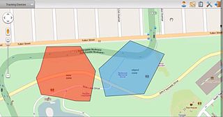
A geofence is a virtual perimeter for a real-world geographic area. A geofence can be dynamically generated or match a predefined set of boundaries.

The Ricoh 500SE digital compact camera is suitable for outdoor photography and networkability. Capability includes external information such as GPS position or barcode numbers within the image headers. External vendors sell hardware and software for workflows involving GPS positioning or barcode scanning. Most NMEA compliant bluetooth GPS receivers can be used with this camera through its built in bluetooth communication capability. The body is resistant to dust and water, making it robust for many environments.

<span class="mw-page-title-main">Nikon D3100</span> Digital camera model

The Nikon D3100 is a 14.2-megapixel DX format DSLR Nikon F-mount camera announced by Nikon on August 19, 2010. It replaced the D3000 as Nikon's entry level DSLR. It introduced Nikon's new EXPEED 2 image processor and was the first Nikon DSLR featuring full high-definition video recording with full-time autofocus and H.264 compression, instead of Motion JPEG compression. It was also the first Nikon DSLR to provide high-definition video recording at more than one frame rate.

<span class="mw-page-title-main">Red Hen Systems</span>

Red Hen Systems, Inc. is a technology company that develops integrated hardware and software solutions for multimedia asset mapping. Their spatial digital video recorders (DVRs) and still cameras instantly geotag video and still photos at the time of data collection. Corresponding mapping software provides the capability to view photographs, video, and audio using GPS coordinates.

<span class="mw-page-title-main">Nikon D5100</span> Digital single-lens reflex camera

The Nikon D5100 is a 16.2-megapixel DX-format DSLR F-mount camera announced by Nikon on April 5, 2011. It features the same 16.2-megapixel CMOS sensor as the D7000 with 14-bit depth, while delivering Full HD 1080p video mode at either 24, 25 or 30fps. The D5100 is the first Nikon DSLR to offer 1080p video at a choice of frame rates; previous Nikon DSLRs that recorded 1080p only did so at 24 fps. It replaced the D5000 and was replaced by the D5200.

In geographic information systems, toponym resolution is the relationship process between a toponym, i.e. the mention of a place, and an unambiguous spatial footprint of the same place.

Geomessaging is a technology that allows a person or system to send a message based on any media to a device that enters or exits one or more regions. Those regions can be created by using geofences, based on Latitude and Longitude, or adding beacons to the system associating those beacons with named locations. The device will receive the message according to the rules defined by the campaign administrator.

References

  1. New York Times Gadgetwise 2010/07/28 Why don't more cameras offer GPS?
  2. CNET UK Archived 2011-08-11 at the Wayback Machine Nikon says No to GPS
  3. "Archived copy" (PDF). Archived from the original (PDF) on 2014-06-30. Retrieved 2011-04-01.{{cite web}}: CS1 maint: archived copy as title (link)
  4. "GPS für (Fast) jede Kamera".
  5. "CES: Samsung's SH100 Wi-Fi-enabled camera". MacWorld. 7 January 2011.
  6. US Army Archived 2010-12-17 at the Wayback Machine
  7. ""Now" App Scans Instagram to Find You Something Fun to do Nearby". 12 January 2013.
  8. In this format, a positively signed coordinate indicates Northern or Eastern hemisphere, while negative sign indicates Southern or Western hemisphere.