
The Gettysburg Address is a speech that U.S. President Abraham Lincoln delivered during the American Civil War at the dedication of the Soldiers' National Cemetery in Gettysburg, Pennsylvania, on the afternoon of November 19, 1863, four and a half months after the Union armies defeated those of the Confederacy at the Battle of Gettysburg. It is one of the best-known speeches in American history.

Memorial Day is a federal holiday in the United States for mourning the U.S. military personnel who have died while serving in the United States armed forces. It is observed on the last Monday of May. It was formerly observed on May 30 from 1868 to 1970.

Gettysburg National Cemetery is a United States national cemetery created for Union/Federal casualties of the July 1 to 3, 1863 Battle of Gettysburg in the American Civil War (1861–1865). It is located just outside Gettysburg Borough to the south, in Adams County, Pennsylvania. The land was part of the Gettysburg Battlefield, and the cemetery is within Gettysburg National Military Park administered by the National Park Service of the United States Department of the Interior.
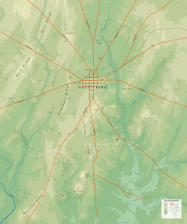
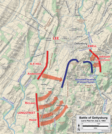
The Gettysburg Battlefield is the area of the July 1–3, 1863, military engagements of the Battle of Gettysburg within and around the borough of Gettysburg, Pennsylvania. Locations of military engagements extend from the 4-acre (1.6 ha) site of the first shot at Knoxlyn Ridge on the west of the borough, to East Cavalry Field on the east. A military engagement prior to the battle was conducted at the Gettysburg Railroad trestle over Rock Creek, which was burned on June 27.

The Lutheran Theological Seminary at Gettysburg was a seminary of the Evangelical Lutheran Church in America (ELCA) in Gettysburg, Pennsylvania. It was one of seven ELCA seminaries, one of the three seminaries in the Eastern Cluster of Lutheran Seminaries, and a member institution of the Washington Theological Consortium. It was founded in 1826 under prominent but controversial theologian and professor Samuel Simon Schmucker (1799-1873) for the recently organized General Synod of the Evangelical Lutheran Church in the United States. The seminary was the oldest continuing Lutheran seminary in the United States until it was merged on July 1, 2017, after 189 years of operation, with the nearby and former rival Lutheran Theological Seminary at Philadelphia to form the United Lutheran Seminary. The new institution continues to use both campuses.

Seminary Ridge is a dendritic ridge which was an area of Battle of Gettysburg engagements in July 1863 during the American Civil War (1861–1865), and of military installations during World War II (1941–1945).
Rock Creek is an 18.9-mile-long (30.4 km) tributary of the Monocacy River in south-central Pennsylvania and serves as the border between Cumberland and Mount Joy townships. Rock Creek was used by the Underground Railroad and flows near several Gettysburg Battlefield sites, including Culp's Hill, the Benner Hill artillery location, and Barlow Knoll.

Evergreen Cemetery – formerly called Citizen's Cemetery and Ever Green Cemetery – is a historic 29.12 acre rural cemetery located just outside Gettysburg Borough, in Cumberland Township, Adams County, Pennsylvania. It is part of Gettysburg Battlefield Historic District, and is surrounded by Gettysburg National Military Park and Soldiers' National Cemetery.
Pennsylvania Route 134 (PA 134), also called Taneytown Road, is a north–south, two-lane state highway in Adams County, Pennsylvania. It runs from the Maryland border at the Mason–Dixon line in Mount Joy Township north to U.S. Route 15 Business in Gettysburg. PA 134 runs through farmland between the Maryland border and an interchange with the US 15 freeway. North of here, the route passes through Round Top and serves Gettysburg National Military Park before reaching its northern terminus. Taneytown Road was created in 1800 to connect Gettysburg with Taneytown, Maryland. The road was used during the 1863 Battle of Gettysburg for the procession to the cemetery consecration at which the Gettysburg Address was delivered. PA 134 was designated to its current alignment in 1928, with the section north of Round Top paved. The southern portion of the route was paved in the 1930s.

The Brian Farm is an American Civil War area of the Gettysburg Battlefield used during the Pickett's Charge. On January 23, 2004, the farm's buildings, Boundary Stone Wall, and ID tablet were designated historic district contributing structures after the tract was used for the 1918 Camp Colt and other postbellum camps.
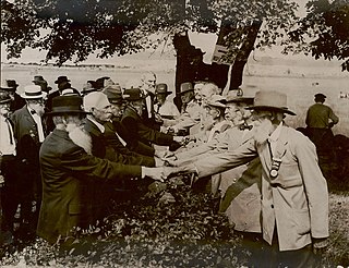
The 1913 Gettysburg reunion was a Gettysburg Battlefield encampment of American Civil War veterans for the Battle of Gettysburg's 50th anniversary. The June 29–July 4 gathering of 53,407 veterans was the largest ever Civil War veteran reunion, and "never before in the world's history [had] so great a number of men so advanced in years been assembled under field conditions". All honorably discharged veterans in the Grand Army of the Republic and the United Confederate Veterans were invited, and veterans from 46 of the 48 states attended.
Harney is an unincorporated community in Carroll County, Maryland, United States. Harney is also the home of the 'World's Best Carnival'. It has been the home of the Harney Volunteer Fire Company since 1951.

The Round Top Branch was an extension of the Gettysburg and Harrisburg Railroad from the Gettysburg borough across the Gettysburg Battlefield to Round Top, Pennsylvania. The branch ran southward from the terminus of the railroad's main line, west of the school and St. Francis Xavier Cemetery, across the field of Pickett's Charge, south of Cemetery Ridge, east of Weikert Hill and Munshower Knoll, and through Round Top to a point between Little Round Top's east base and Taneytown Road. In addition to battlefield tourists, the line carried stone monoliths and statues for monuments during the battlefield's memorial association and commemorative eras and equipment, supplies and participants for Gettysburg Battlefield camps after the American Civil War.

The 1938 Gettysburg reunion was an encampment of American Civil War veterans on the Gettysburg Battlefield for the 75th anniversary of the Battle of Gettysburg. The gathering included approximately 25 veterans of the battle with a further 1,359 Federal and 486 Confederate attendees out of the 8,000 living veterans of the war. The veterans averaged 94 years of age. Transportation, quarters, and subsistence was federally funded for each veteran and their accompanying attendant. If an attendant was needed it was provided. President Franklin D. Roosevelt's July 3 reunion address preceded the unveiling of the Eternal Light Peace Memorial; a newsreel with part of the address was included in the Westinghouse Time Capsule for the 1939 New York World's Fair.

Barlow, Pennsylvania is a populated place between the Gettysburg Battlefield and the Mason–Dixon line at the intersection of Rock Creek and Pennsylvania Route 134. North of the creek on the road summit is the principal facility of the rural community: the 1939 community hall at the Barlow Volunteer Fire Company fire station. The hall is a Cumberland Township polling place and was used by Mamie & Dwight D. Eisenhower after purchasing their nearby farm. Horner's Mill was the site of an 1861 Union Civil War encampment, and the covered bridge was used by the II Corps and General George G. Meade en route to the 1863 Battle of Gettysburg.
Emmor Cope was an American Civil War officer of the Union Army noted for the "Map of the Battlefield of Gettysburg from the original survey made August to October, 1863", which he researched by horseback as a sergeant after being ordered back to Gettysburg by Maj. Gen. George G. Meade. Cope is also noted for commemorative era battlefield administration and designs, including the layout of the 1913 Gettysburg reunion. Cope had enlisted as a Private of Company A,, temporarily detached to Battery C, 5th U.S. Artillery, and mustered out as a V Corps aide-de-camp of Maj Gen Gouverneur K. Warren.

The Soldiers' National Monument is a Gettysburg Battlefield memorial which is located at the central point of Gettysburg National Cemetery. It honors the battle's soldiers and tells an allegory of "peace and plenty under freedom … following a heroic struggle." In addition to an inscription with the last 4 lines of the Gettysburg Address, the shaft with 4 buttresses has 5 statues:
A large statue representing the concept of Liberty surmounts the pedestal. Eighteen large bronze stars circling the pedestal below this statue represent the eighteen Union states with buried dead. A statue is located at each corner near the base. They represent War, History, Peace, and Plenty. War is represented by a statue of an American soldier who recounts the story of the battle to History. In turn, History records, with stylus and tablet, the achievements of the battle and the names of the honored dead. A statue of an American mechanic and his tools illustrates Peace. Plenty is a female figure with a sheaf of wheat and the fruits of the earth that typify peace and abundance as the soldier's crowning triumph.

The Gettysburg Battlefield Memorial Association (GBMA) was an historic preservation membership organization and is the eponym for the battlefield's memorial association era. The association was chartered by the Commonwealth of Pennsylvania on April 13, 1864, after attorney David McConaughy recommended on August 14, 1863, a preservation association to sell membership stock for battlefield fundraising. McConaughy transferred his land acquired in 1863 to the GBMA, and the association's boardmembers were initially local officials. The GBMA sold stock to raise money, hired a superintendent at $1000/yr, added to McConaughy's land holdings, and operated a wooden observation tower on East Cemetery Hill from 1878–95.
The Consecration of the Soldiers' National Cemetery was the ceremony at which U.S. President Abraham Lincoln delivered the Gettysburg Address on November 19, 1863. In addition to the 15,000 spectators, attendees included six state governors: Andrew Gregg Curtin of Pennsylvania, Augustus Bradford of Maryland, Oliver P. Morton of Indiana, Horatio Seymour of New York, Joel Parker of New Jersey, and David Tod of Ohio. Reporters present included Joseph Gilbert, Charles Hale, John Russell Young ; and Cincinnati Commercial, New York Tribune, & The New York Times reporters.

McPherson Ridge is a landform used for military engagements during the 1863 Battle of Gettysburg, when the I Corps of the Union Army had a headquarters on the ridge and was defeated by the Confederate division of Major General Henry Heth. The ridge has terrain above ~530 ft (160 m) and is almost entirely a federally protected area except for township portions at the southern end and along Pennsylvania Route 116, including a PennDOT facility. The northern end is a slight topographic saddle point on the west edge of Oak Ridge, and summit areas above 560 ft (170 m) include 4 on/near the Lincoln Highway, a broader summit south of the Fairfield Road, and the larger plateau at the northern saddle.
