
The Toronto Islands are a chain of 15 small islands in Lake Ontario, south of mainland Toronto, Ontario, Canada.
The Battle of York was a War of 1812 battle fought in York, Upper Canada on April 27, 1813. An American force, supported by a naval flotilla, landed on the western lakeshore and captured the provincial capital after defeating an outnumbered force of regulars, militia and Ojibwe natives under the command of Major General Roger Hale Sheaffe, the Lieutenant Governor of Upper Canada.
Fort George was a military fortification in Niagara-on-the-Lake, Ontario, Canada. The fort was used by the British Army, the Canadian militia, and the United States Armed Forces for a brief period. The fort was mostly destroyed during the War of 1812. The site of the fort has been a National Historic Site of Canada since 1921, and features a reconstruction of Fort George.

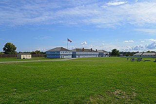
Fort York is an early 19th-century military fortification in the Fort York neighbourhood of Toronto, Ontario, Canada. The fort was used to house members of the British and Canadian militaries, and to defend the entrance of the Toronto Harbour. The fort features stone-lined earthwork walls and eight historical buildings within them, including two blockhouses. The fort forms a part of Fort York National Historic Site, a 16.6 ha (41-acre) site that includes the fort, Garrison Common, military cemeteries, and a visitor centre.

Toronto Harbour or Toronto Bay is a natural bay on the north shore of Lake Ontario, in Toronto, Ontario, Canada. Today, the harbour is used primarily for recreational boating, including personal vessels and pleasure boats providing scenic or party cruises. Ferries travel from docks on the mainland to the Islands, and cargo ships deliver aggregates and raw sugar to industries located in the harbour. Historically, the harbour has been used for military vessels, passenger traffic and cargo traffic. Waterfront uses include residential, recreational, cultural, commercial and industrial sites.
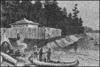
Fort Rouillé was a French trading post located in what is now Toronto, Ontario, Canada. Fort Rouillé was constructed by the French in 1751, building upon the success of a trading post they established in the area a year earlier, known as Fort Toronto. Fort Rouillé was named for Antoine Louis Rouillé, who at the time of its establishment was Secretary of State for the Navy in the administration of King Louis XV of France. It served as a trading post with the local indigenous peoples from the region.
The Raid on Gananoque was an action conducted by the United States Army on 21 September 1812 against Gananoque, Upper Canada during the War of 1812. The Americans sought to plunder ammunition and stores to resupply their own forces. Gananoque was a key point in the supply chain between Montreal and Kingston, the main base of the Provincial Marine on the Great Lakes. Under the command of Captain Benjamin Forsyth, the Americans departed Ogdensburg, New York and sailed to Gananoque, where they encountered resistance from the 2nd Regiment of Leeds Militia. The British militia was forced to retreat and the Americans successfully destroyed the storehouse and returned to the United States with captured supplies. As a result of the raid, the British strengthened their defences along the St. Lawrence River.

The Gibraltar Point Lighthouse is a lighthouse located on the Toronto Islands in Toronto, Ontario, Canada. Begun in 1808, it is the oldest existing lighthouse on the Great Lakes, and one of Toronto's oldest buildings. The lighthouse is perhaps best known for the demise of its first keeper, German-born John Paul Radelmüller, whose 1815 murder forms the basis of Toronto's most enduring ghost story. Recent research has verified many aspects of the traditional tale of his death and identified the soldiers charged with but ultimately acquitted of the crime.

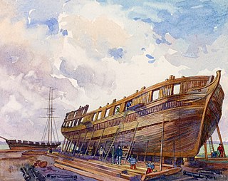
Nancy was a schooner, built in Detroit, Michigan and launched in 1789. She served for several years in the fur trade on the Great Lakes, but is best known for playing a part in the Anglo-American War of 1812. She served for several years as a vital supply ship for the Provincial Marine. The Royal Navy took over the Provincial Marine in 1814 and so acquired Nancy. After HMS Nancy was blocked in by an American fleet near the mouth of the Nottawasaga River, her crew set her on fire on 14 August 1814 to prevent the capture of the ship and the cargo she carried. Forgotten for many years, the wreck was re-discovered in July 1927 and raised to form the centrepiece of the Nancy Island Museum.

Amherstburg Royal Naval Dockyard was a Provincial Marine and then a Royal Navy yard from 1796 to 1813 in Amherstburg, Ontario, situated on the Detroit River. The yard comprised blockhouses, storehouses, magazine, wood yard and wharf. The yard was established in 1796 to support the Upper Canada Provincial Marine after Great Britain ceded a pre-existing shipyard on the Detroit River to the United States. Amherstburg Royal Naval Dockyard constructed four warships for the Lake Erie detachment of the Provincial Marine before and during the War of 1812. In 1813 the dockyard was abandoned and destroyed when the British retreated and never reopened. In 1928, the site was designated a National Historic Site of Canada.
The Naval Shipyards were naval shipbuilding facilities used by the Provincial Marine and the Royal Navy in York, Upper Canada. The naval shipyards were ordered by the Lieutenant Governor of Upper Canada John Graves Simcoe in 1793, and were opened in 1798.

Fort Wellington National Historic Site is a historic military fortification located on the north shore of the St. Lawrence River at Prescott, Ontario. The military fortification was used by the British Army, and the Canadian militia for most of the 19th century, and by the militia in the 20th century, until 1923, when the property was handed over to the Dominion Parks Commission, the predecessor to Parks Canada. The fort was earlier named a National Historic Site of Canada in January 1920.

Fort Mississauga National Historic Site is a fort on the shore of Lake Ontario, at the mouth of the Niagara River in Niagara-on-the-Lake, Ontario, Canada. The fort today consists of a box–shaped brick tower and historic star–shaped earthworks. The all–brick fort was built from 1814–1816 during the War of 1812, to replace nearby Fort George. It was built on a foundation of brick and stone salvaged from rubble left after retreating United States forces burned the nearby town of Newark in December, 1813. It would help in the defence of Upper Canada the following year, as part of a regional network that included Fort George, Navy Hall, and Butler's Barracks. However, the fort would not be completed until after the war.
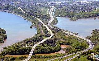
Burlington Heights refers to a promontory or area of flat land sitting elevated above the west end of Hamilton Harbour in the city of Hamilton, Ontario which continues as a peninsula to the north toward the city of Burlington, Ontario. It separates Cootes Paradise Marsh on the west from the harbor on the east. Geologically the Burlington Heights is a sand and gravel bar formed across the eastern end of the Dundas Valley by Glacial Lake Iroquois. It is the northern continuation of the longer Iroquois Bar which extends south into Hamilton.

John Cox Cottage, at 469 Broadview Avenue, Toronto, Ontario, Canada, is the oldest known house in the city still used as a residence, and it still resides on its original site. The property, immediately to the east of what was John Scadding's original lot, was deeded to John Cox by Governor Simcoe in 1796.

Magasin royal was the generic name given to a trading post under the purview of the King of France. The name also applied specifically to two trading posts that were built during the 18th century for French fur trading near the Humber River in the Pays d'en Haut region of New France, in present-day Toronto, Ontario, Canada. According to Ron Brown, author of From Queenston to Kingston: The Hidden Heritage of Lake Ontario's Shoreline, the fort was "little more than a log cabin", and archeologists considered it "the first non-aboriginal building in the Toronto area".

Fort Howe was a British fort built in Saint John, New Brunswick during the American Revolution. It was erected shortly after the American siege in 1777 to protect the city from further American raids. The 18th and 19th century British Army fortification stood at the mouth of the Saint John River where it empties into the Bay of Fundy. A replica blockhouse has been constructed approximately 250 metres to the northeast of the original structure.

Following the Upper Canada Rebellion of 1837 Lieutenant Governor of Upper Canada Sir George Arthur directed the construction of a Sherbourne Blockhouse, and a ring of six other blockhouses -- to guard the approaches to Toronto in case there was another rebellion. The Sherbourne Blockhouse was located at the northern end of Sherbourne Street, at the current intersection with Bloor, just south of the Rosedale Ravine.

The Bois Blanc Island Lighthouse and Blockhouse is a National Historic Site of Canada located in Ontario on Bois Blanc Island, one of the islands in the Detroit River. It consists of a lighthouse, owned by Parks Canada, and a blockhouse, which is privately owned.
Fort au Fer was a British fort, established in 1775 on Lake Champlain, New York approximately 1 mile south of Rouses Point. It was occupied by General John Burgoyne during his Saratoga campaign in 1777, and remained in British hands until 1796, following the 1794 Jay Treaty.


