Gilcrux

Last updated

Gilcrux
St Mary's Church, Gilcrux - geograph.org.uk - 1805343.jpg
St. Mary's Church, Gilcrux
Location map United Kingdom Allerdale.svg
Red pog.svg
Gilcrux
Location in Allerdale, Cumbria
Cumbria UK location map.svg
Red pog.svg
Gilcrux
Location within Cumbria
Population299 (2011 Census)
OS grid reference NY115381
Civil parish
  • Gilcrux
District
Shire county
Region
Country England
Sovereign state United Kingdom
Post town WIGTON
Postcode district CA7
Dialling code 01697
Police Cumbria
Fire Cumbria
Ambulance North West
UK Parliament
List of places
UK
England
Cumbria
54°43′48″N3°22′30″W / 54.730°N 3.375°W / 54.730; -3.375

Gilcrux is a small village and civil parish in the ceremonial county of Cumbria, England, and historically part of Cumberland. It is situated just outside the Lake District National Park. [1]

Contents

The village is on the south bank of the River Ellen around 5 miles (8 km) north of Cockermouth [2] and around 37 kilometres (23 mi) southwest of Carlisle [3] the County town of Cumbria. An early record of the village is shown on a map of the Cumbria area by Christopher Saxton in 1567, in which the village is known as Gilcrosse. [4]

Etymology

The name Gilcrux may be derived from the Brittonic [5] elements *cīl meaning "a nook/retreat", [5] and -crṻg meaning "an isolated or abrupt hill", [5] and may have originally meant "hill retreat". [6] Also possible is derivation from Gaelic *cil-cruaich, "a church with a cross". [5] The present form of the name has been influenced by Old Norse gil, "a ravine" and Latin crux, "a cross". [5]

History

Census data shows the changes in the population of the parish over time. Censuses are recorded at 10-year intervals in the United Kingdom with the earliest records for population coming from the 1801 UK census. The graph in Figure 1 shows that the population increased steadily until 1891, after which it decreased slowly to its current figure. [7]

Figure 1 (Population Change) Populationchange.jpg
Figure 1 (Population Change)

The increase in population is explained by John Marius Wilson in his Imperial Gazetteer of England and Wales, the increase in residents was due to the extensions of coal mines in the area. [8]

Figure 2: Occupational Structure of Gilcrux, 1831 Social Status, based on 1831 occupational statistics, Gilcrux.jpg
Figure 2: Occupational Structure of Gilcrux, 1831

Census data also reflects the social structure of the parish in 1831. The pie chart in Figure 2 shows the proportion of Gilcrux's workforce in very broad categories. Half of the total population worked as labourers and servants on the parish farms, and were most likely employed by those in the 'Employers and Professionals' group, which make up almost a quarter of the total population. [10]

Governance

Gilcrux, is part of the Workington constituency of the UK parliament. The current Member of Parliament is Mark Jenkinson, a member of the Conservative Party. [11] The Labour Party won the seat in every general election from 1979 to 2017; the Conservative Party has only been elected twice in Workington since the Second World War: in the 1976 Workington by-election and in the 2019 general election. [12]

For the European Parliament residents in Gilcrux voted to elect MEP's for the North West England constituency.

For Local Government purposes it is in the Ellen & Gilcrux Ward of Allerdale Borough Council, formerly part of Cockermouth Rural District and the Dearham and Broughton Division of Cumbria County Council.

The village also has its own Parish Council together with part of Bullgill; Gilcrux Parish Council. [13]

Landmarks

The village contains St. Mary's church, which sits atop of a mound in the centre of the village. The church dates back to Norman times and was renovated in the late 13th century. [14] The church has an Anglo-Danish Norse cross on its roof [15] and contains a glass altar screen of Leonardo da Vinci's painting of The Last Supper.

The Village also contains a newly refurbished village hall, building work started on the village hall in January 2010, [16] and was completed in March 2012, costing £580,000, much of which came from national lottery funding. [17] The refurbishments included a glass entrance lobby, more meeting rooms, a bar area and improved toilet facilities. [17]

The Village also contains the Beeches Caravan Park, the villages close proximity to the Lake District make it an attractive location for tourists, with the caravan park being open all year round. [18]

Transport

By road, Gilcrux is close to two major roads, the A596 which is around 2 miles (3.2 km) north of the village, [19] and the A595 which is around 3.7 miles (6.0 km) to the south. [20] These two roads link the village with the town of Carlisle which is around 23 miles (37 km) away.

A bus service is the only form of Public Transport in Gilcrux. The 39 bus is active on Tuesdays and Fridays and completes its route from Bothel to Carlisle once on these days [21]

The nearest train station is Aspatria railway station which is roughly 3.4 miles (5.5 km) away from Gilcrux. The station runs trains everyday northbound towards Carlisle and southbound towards Barrow-in-Furness. [22]

Demographics

According to the United Kingdom Census 2001 the population of the parish was 303, [23] with the parish containing 119 households in total. [24] reducing at the 2011 Census to a population of 299 in 132 households. [25]

There are 145 people between the ages of 16 and 74 that are economically active, with 9 people in that age bracket unemployed and a further 66 economically inactive. Employment within the parish is split between the extractive and manufacturing industries, in which 41% of the population are employed, and the service industry, which employs the remaining 59% of the economically active employed population of Gilcrux. [26] The census data also allows us to see the mean distance that the residents of Gilcrux have to travel to their place of employment, the figure given is 14.55 miles (23.42 km) [26] this could suggest that few people remain in the parish to work and instead commute to large settlements each day for work.

Climate

Climate data for Gilcrux, Cumbria, England
MonthJanFebMarAprMayJunJulAugSepOctNovDecYear
Average high °C (°F)6
(43)
7
(45)
9
(48)
11
(52)
15
(59)
17
(63)
19
(66)
19
(66)
16
(61)
13
(55)
9
(48)
7
(45)
12
(54)
Average low °C (°F)2
(36)
2
(36)
3
(37)
4
(39)
6
(43)
9
(48)
12
(54)
11
(52)
9
(48)
7
(45)
4
(39)
2
(36)
6
(43)
Average precipitation cm (inches)9.39
(3.70)
8.09
(3.19)
7.33
(2.89)
5.41
(2.13)
5.62
(2.21)
6.38
(2.51)
6.14
(2.42)
7.15
(2.81)
8.32
(3.28)
11.09
(4.37)
9.85
(3.88)
10.47
(4.12)
95.24
(37.51)
Source: www.bing.com [27]

Notable people

See also

Related Research Articles

<span class="mw-page-title-main">Cumberland</span> Historic county of England

Cumberland is a historic county in North West England, covering part of the Lake District as well as the northern Pennines and the coast of Solway Firth. Cumberland had an administrative function from the 12th century until 1974, when it was subsumed into Cumbria, a larger administrative area which also covered Westmorland and parts of Yorkshire and Lancashire. In April 2023, Cumberland was revived as an administrative entity when Cumbria County Council was abolished and replaced by two unitary authorities, one of which is named Cumberland and includes most of the historic county, with the exception of Penrith and the surrounding area.

<span class="mw-page-title-main">Cockermouth</span> Town and parish in England

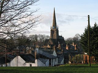
Cockermouth is a market town and civil parish in Cumbria, England, so named because it is at the confluence of the River Cocker as it flows into the River Derwent. The mid-2010 census estimates state that Cockermouth has a population of 8,204, increasing to 8,761 at the 2011 Census.

<span class="mw-page-title-main">Aspatria</span> Human settlement in England

Aspatria is a town and civil parish in Cumberland, Cumbria, England. The town rests on the north side of the Ellen Valley, overlooking a panoramic view of the countryside, with Skiddaw to the South and the Solway Firth to the North. Its developments are aligned approximately east–west along the A596 Carlisle to Workington road and these extend to approximately 2 miles (3.2 km) in length. It lies about 8 miles (13 km) northeast of Maryport, a similar distance to the Southwest of Wigton, about 9 miles (14 km) north of Cockermouth and 5 miles (8.0 km) from the coast and Allonby. It comprises the townships of Aspatria and Brayton, Hayton and Mealo, and Oughterside and Allerby, the united area being 8,345 acres (3,377 ha); while the town takes up an area of 1,600 acres (647 ha). In earlier days a Roman road leading from "Old Carlisle" to Ellenborough passed through the hamlet.

<span class="mw-page-title-main">Allerdale</span> Former non-metropolitan district in England

<span class="mw-page-title-main">Tallentire</span> Human settlement in England

Tallentire is a village and former civil parish, now in the parish of Bridekirk, in the Cumberland district of Cumbria, England. It is about 2.5 miles (4.0 km) north of Cockermouth. The village is located just outside the Lake District National Park. In 1931 the parish had a population of 184.

<span class="mw-page-title-main">Brigham, Cumbria</span> Human settlement in England

Brigham is a village in Cumbria, England. The village is near to the town of Cockermouth and is located just outside the Lake District National Park.

<span class="mw-page-title-main">Bassenthwaite</span> Village and civil parish in England

Bassenthwaite is a village and civil parish to the west of Bassenthwaite Lake in Cumbria, historically part of Cumberland, within the Lake District National Park, England. According to the 2001 census it had a population of 412, increasing to 481 at the 2011 Census. There is a Church of England Church, St John's Bassenthwaite and a tiny Methodist chapel. The village contains many elements of the archetypal English village including a green, primary school and a stream that runs through it.

<span class="mw-page-title-main">Bothel and Threapland</span> Human settlement in England

Bothel and Threapland is a civil parish in Cumbria, England, just outside the Lake District National Park. According to the 2001 census, it had a population of 438. The parish includes the villages of Bothel and Threapland. The village of Bothel is south-east of the parish of Aspatria and Threapland is south of Aspatria and Carlisle is eighteen miles (29 km) North-east of the parish. It had a population of 483 in the 2011 census figures.

<span class="mw-page-title-main">Broughton Moor</span> Village in Cumbria, England

Broughton Moor is a village and civil parish in Cumbria, England. It is situated on an extensive moor about 2 miles (3.2 km) north of Broughton, 5 miles (8.0 km) north west of Cockermouth, 2.5 miles (4.0 km) south of Maryport and 4.5 miles (7.2 km) north of Workington.

<span class="mw-page-title-main">Greysouthen</span> Human settlement in England

Greysouthen is a village and civil parish between the towns of Workington and Cockermouth, in Cumbria, North West England, historically part of Cumberland, near the Lake District National Park. The village has an historic association with coal mining.

<span class="mw-page-title-main">Bridekirk</span> Human settlement in England

Bridekirk is a village and civil parish in the Cumberland district in the county of Cumbria, England. It is around 3.2 kilometres (2 mi) north of the Derwent river and about the same distance from the nearest large town of Cockermouth just south of the river. Bridekirk is just outside the Lake District National Park and is not far from the Maryport and Carlisle Railway.

<span class="mw-page-title-main">Mealsgate</span> Human settlement in Cumbria, United Kingdom

Mealsgate is a village in Cumbria, England, historically within Cumberland.

<span class="mw-page-title-main">Fletchertown</span> Human settlement in England

Fletchertown is a small village in the Allerdale borough of Cumbria, England. It was historically within Cumberland.

<span class="mw-page-title-main">Dearham</span> Village in Cumbria, England

Dearham is a village and civil parish in Cumbria, historically part of Cumberland, near the Lake District National Park in England. It lies about 2 miles (3.2 km) east of Maryport and 5 miles (8.0 km) west of Cockermouth.

<span class="mw-page-title-main">Great Broughton, Cumbria</span> Village in Cumbria, England

Great Broughton is a village and former civil parish, now in the parish of Broughton, in the Cumberland district, in the ceremonial county of Cumbria, England. It caters strongly for visitors. The estimated resident population was 1,823 in 2017.

<span class="mw-page-title-main">Little Broughton</span> Village in Cumbria, England

Little Broughton is a village and former civil parish, now in the parish of Broughton, in the Allerdale district, in the county of Cumbria, England, located 3 miles (4.8 km) west of Cockermouth. In 1891 the parish had a population of 820.

<span class="mw-page-title-main">Dovenby</span> Human settlement in England

Dovenby is a village and former civil parish, now in the parish of Bridekirk, in the Cumberland district, in the county of Cumbria, England. It is on the A594 road and is 2.5 miles (4.0 km) north west of Cockermouth, 2.6 miles (4.2 km) east of Dearham, 4.5 miles (7.2 km) east of Maryport, 7.4 miles (11.9 km) north east of Workington and 27 miles (43.5 km) south west of Carlisle. In 1931 the parish had a population of 163.

<span class="mw-page-title-main">Hayton, Allerdale</span> Village in England

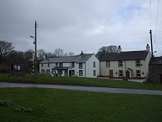
Hayton is a village in the Cumberland unitary authority area of Cumbria, England. It is the only settlement in the civil parish of Hayton and Mealo. Historically located in Cumberland, and on a minor road between the B5300 and the A596, it is approximately 2 miles from the coast. Nearby settlements include the town of Aspatria and the villages of Oughterside and Prospect. A small tributary called Patten Beck runs across the village, through the grounds of the castle.

<span class="mw-page-title-main">Little Clifton</span> Human settlement in England

Little Clifton is a village and civil parish in the district of Allerdale located on the edge of the Lake District in the county of Cumbria, England. In 2001, it had a population of 391 and contained 170 households; increasing to a population of 480 in the 2011 Census with 207 households.

References

  1. "GEOnet Names Server (GNS)". Archived from the original on 9 March 2008. Retrieved 2 August 2009.
  2. "GENUKI:Gilcrux,Cumberland" . Retrieved 1 May 2012.
  3. "Bing Maps Directions" . Retrieved 1 May 2012.
  4. "Old Cumbria Gazetteer" . Retrieved 1 May 2012.
  5. 1 2 3 4 5 James, Alan. "A Guide to the Place-Name Evidence" (PDF). SPNS - The Brittonic Language in the Old North. Archived from the original (PDF) on 13 August 2017. Retrieved 25 November 2018.
  6. "Institute for Name-Studies Website" . Retrieved 30 April 2012.
  7. 1 2 "A Vision of Britain Through Time" . Retrieved 30 April 2012.
  8. "A Vision of Britain Through Time" . Retrieved 30 April 2012.[ permanent dead link ]
  9. "A Vision of Britain through time, Gilcrux" . Retrieved 1 May 2012.
  10. "A Vision of Britain Through time, Gilcrux" . Retrieved 1 May 2012.
  11. "Allerdale Borough Council website". Archived from the original on 7 April 2012. Retrieved 4 April 2012.
  12. "A vision of Britain website – general elections section" . Retrieved 27 April 2012.
  13. "Gilcrux Parish Council".
  14. "The Cumbria Directory, Gilcrux" . Retrieved 1 May 2012.
  15. "Visit Cumbria" . Retrieved 1 May 2012.
  16. "Cumberland News, Gilcrux Village Hall" . Retrieved 5 February 2012.
  17. 1 2 "News and Star, Gilcrux Village Hall". Archived from the original on 4 September 2012. Retrieved 5 February 2012.
  18. "Beeches Caravan Park" . Retrieved 5 February 2012.
  19. "Bing Maps" . Retrieved 25 April 2012.
  20. "Bing Maps" . Retrieved 25 April 2012.
  21. "Service 39" (PDF). Archived from the original (PDF) on 8 April 2012. Retrieved 25 April 2012.
  22. "Carlisle-Barrow Timetable" (PDF). Retrieved 25 April 2012.
  23. "Office for National Statistics Website" . Retrieved 19 April 2012.
  24. "Office for National Statistics Website" . Retrieved 19 April 2012.
  25. "Parish population 2011" . Retrieved 19 June 2015.
  26. 1 2 "Office for National Statistics Website" . Retrieved 19 April 2012.
  27. "Weather in Gilcrux, wigton" . Retrieved 25 April 2012.[ permanent dead link ]

Commons-logo.svg Media related to Gilcrux at Wikimedia Commons